Quincy
-
Posts
6,220 -
Joined
-
Last visited
Content Type
Profiles
Blogs
Forums
American Weather
Media Demo
Store
Gallery
Everything posted by Quincy
-

Severe Weather October 10th-12th 2021
Quincy replied to Sydney Claridge's topic in Central/Western States
Pretty impressive low level wind profiles. LLJ in the 50-60kt range at 850mb with 0-1km SRH of 400-600 m2/s2. The line is even breaking into semi discrete storms in the eastern Texas panhandle, although deep shear vectors become increasingly parallel to the cold front with southward extent. -
Severe Weather October 10th-12th 2021
Quincy replied to Sydney Claridge's topic in Central/Western States
Cell in NW Oklahoma is definitely on the cool side of the warm front and will probably dissipate. The cell west of Chickasha appears to be near or just NE of the warm front and will likely weaken over time, keeping OKC out of the main threat. It may pose an isolated tornado threat for another hour or two The focus shifts west to the MDT risk zone where supercell structures are embedded within a squall line. The best moisture is south of the KS/OK border, but strong low-level shear may support some continued tornado risk in southwestern Kansas, despite a stable near-surface layer. -
Severe Weather October 10th-12th 2021
Quincy replied to Sydney Claridge's topic in Central/Western States
Great AFD out from NWS Amarillo… Area Forecast Discussion National Weather Service Amarillo TX 314 PM CDT Tue Oct 12 2021 .MESOSCALE UPDATE... ...Severe weather likely tonight... * Synoptic Overview: The much-ballyhooed strong western CONUS upper low is finally knocking at our doorstep. Strong upper level forcing will overspread an increasingly juicy surface with the best dynamics set to impinge on the area beginning around sunset. Trends in the synoptic scale have been a little slower and a little further west with the best sfc moisture, meaning a few more folks in the Panhandles could get in the action. The rest of this discussion predominately applies to the eastern half of the combined Panhandles. * Mesoscale: So much to unpack in the mesoscale, we`ll break it down into PROS and CONS for a significant severe event... PROS: - Very strong vertical wind shear with bulk and effective shear values 60-70 kts among a near-perfectly turning profile. In addition to promoting a supercell storm mode with any discrete convection, shear-induced buoyancy will increase the strength of updrafts. - Some of the best shear is in the low levels, with 0-1 SRH values exceeding 400 m2/s2. - Surface moisture has been underestimated in the models so far today, and even so, model forecasts for MLCAPE this evening are in excess of 2500 J/kg. - Strong surface moisture advection will allow sfc theta-e values to INCREASE after sunset in spite of falling temperatures. - Low level forcing for ascent is pretty weak until a cold front sweeps through very late tonight, not clearing the eastern Panhandles until nearly 3 AM. This will likely help foster at least a quasi-discrete storm mode. As we like to say in the Panhandles, when in doubt, discrete wins out. - For any rooted storms, LCLs are basically scraping the ground. That`s not common around here. - There are more PROS but we`ll keep it to these for now. CONS: - A strong (though not deep) isothermal layer bordering on an inversion is forecast by all models to develop after sunset around h8. Resulting low level lapse rates are expectedly putrid in this narrow layer and will almost certainly hamper weaker convection and even probably hamper ongoing supercells. - That`s honestly about it for major cons, but it`s a pretty big one as it could keep convection slightly elevated (doesn`t limit the hail threat but would limit tornado threat). * Threats: The most likely threats will be the potential for very large hail and potentially destructive wind gusts but the most concerning threat will be the possibility for strong and potentially long-tracked tornadoes. Strong and violent tornadoes tend to happen in the presence of MLCAPE, MLLCL, and shear numbers similar to what was discussed above. * Timing & Location: The worst of it should be 6 PM - 2 AM tonight east of a roughly Guymon to Panhandle to Claude line. Storms will be moving at very high rates of speeds, likely over 50 MPH and in the dark so that will increase the danger. * Summary: This event has the potential to be a top 3 Panhandles severe event in 2021. Simpson -
Severe Weather October 10th-12th 2021
Quincy replied to Sydney Claridge's topic in Central/Western States
Seems to have a bit more potential than Sunday night. Still think the storm mode may get messy, but even with those concerns, I’d expect at least a few noteworthy tornadoes after dark. Moisture return has been steadily occurring with mid/upper 50s dew points already into the OK/TX panhandles. Placement and timing remind me a bit of 11/16/15. Can’t overlook the intensity of the low level jet tonight. -
Severe Weather October 10th-12th 2021
Quincy replied to Sydney Claridge's topic in Central/Western States
Recent HRRR runs show a sharp dryline bulge forming in far southwestern Oklahoma this afternoon with convective initiation around 23z. Of course these solutions feature a lone supercell tracking toward OKC after dark. Let’s not do that again. -
Severe Weather October 10th-12th 2021
Quincy replied to Sydney Claridge's topic in Central/Western States
High res models handled this event well. SPC seemed to go rather aggressive, despite messy CAM solutions and deep shear vectors nearly parallel to the cold front and dryline. Maybe Oklahoma bias? The models did handle the triple point semi-discrete supercell well. Storm chasing was a pain today as everyone and their neighbor’s uncle was out. I’m glad it busted, for safety sake. OKC dodges another one. -
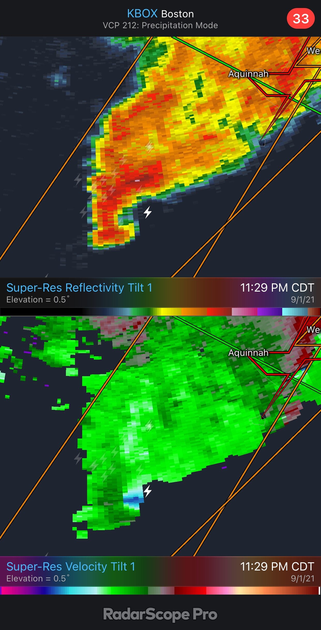
Several classic supercells near the coast tonight. A rare sight

-
How can I better help explain it, Kev?
-
Tornado threat is pretty cooked. Virtually no instability and substantial convective inhibition, both analyzed and forecast. Favorable low level shear is also becoming increasingly displaced to the north.
-
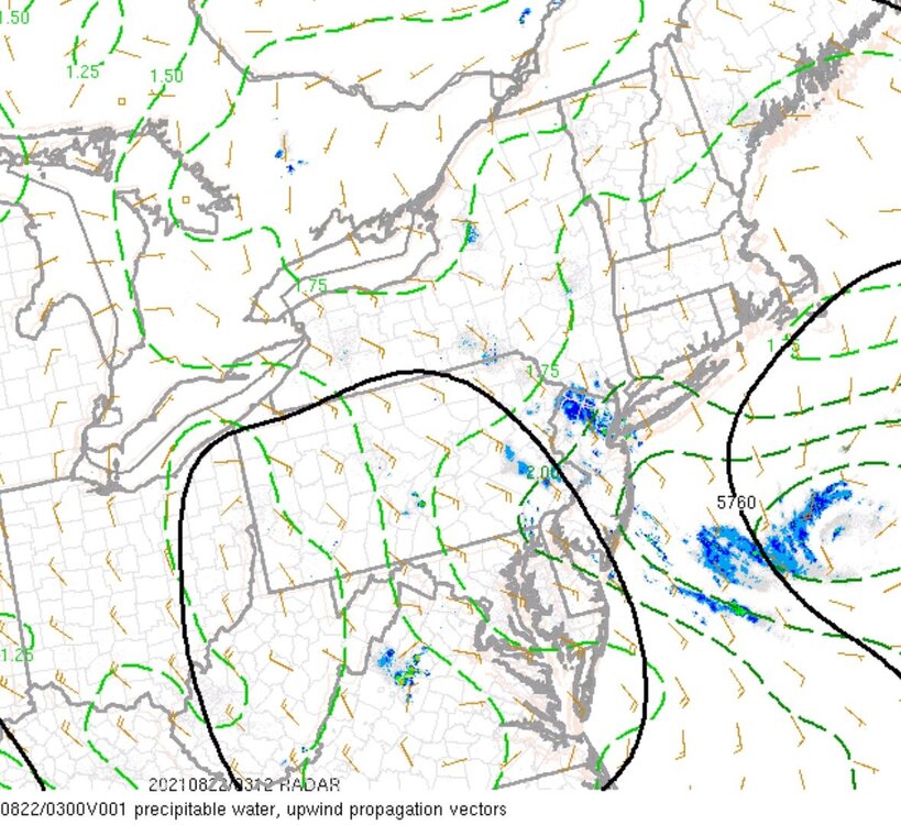
Tropical Storm Henri Tropical Cyclone Update NWS National Hurricane Center Miami FL AL082021 1230 PM EDT Sun Aug 22 2021 ...TROPICAL STORM HENRI MAKES LANDFALL ALONG THE COAST OF RHODE ISLAND NEAR WESTERLY... Data from an Air Force Reserve reconnaissance aircraft, NOAA Doppler weather radars, and surface observations indicate that the center of Tropical Storm Henri made landfall along the coast of Rhode Island near Westerly at approximately 1215 PM EDT this afternoon. At the time of landfall, maximum sustained winds were estimated to be 60 mph. A Weatherflow station near Point Judith, Rhode Island, recently measured a sustained wind of 57 mph (92 km/h) and a gust to 70 mph (113 km/h). The center of Henri passed over Block Island, Rhode Island, around 1100 AM EDT...1500 UTC.
-
BID is back online. Almost reaching TS verification. Sustained winds 27 knots at the top of the hour. Gusting to 48 knots. 998.1mb
-
Impressive inland wind field
-
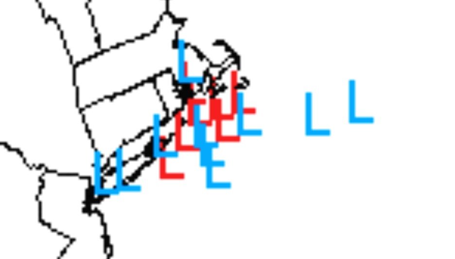
Not sure a sharp NW curve is coming, but due north takes the center to MVY. Should see a modest bend NNW. Thinking the center comes close to BID.
-
SREF mostly clustered near the general model consensus, but at least two members keep the center offshore.
-
00z HRRR sneaks in between MTP and BID. Very lopsided rainfall-wise. Almost nothing on the east side by landfall:
-
While Hurricane Henri Gently Weakens
-
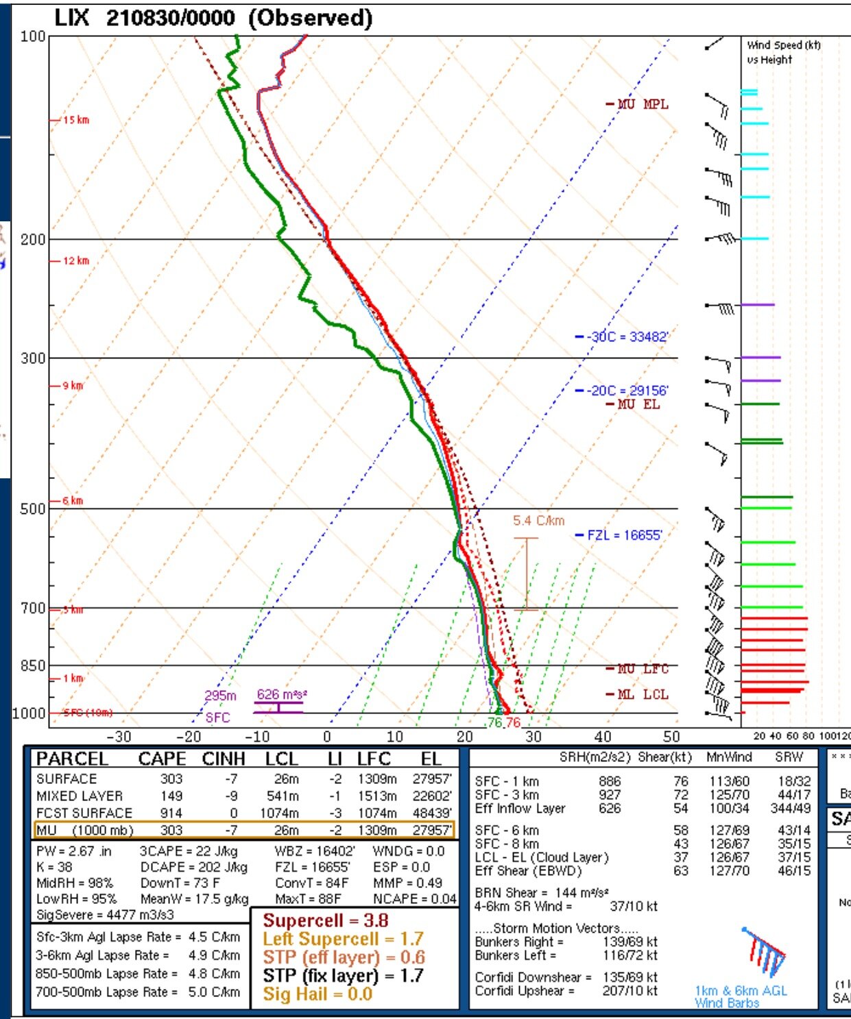
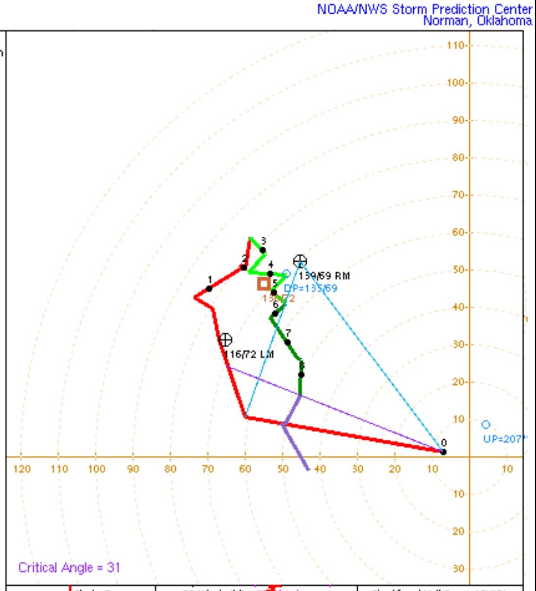
Forgot to mention that the low level wind shear over Rhode Island tomorrow supports up to an EF-4 tornado
-
Satellite imagery depicts what you’d expect to see from a marginal cat 1 that’s more or less remaining steady state.
-
My only guess is tree density and hills maybe? Still seems kind of odd, especially if longer duration damaging winds are expected in far SE CT.
-
21z RAP took a huge jump east. Landfall near New Bedford now. Lol
-
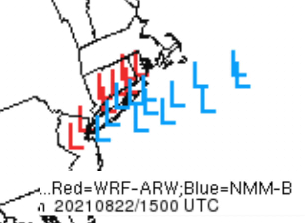
SREF showing greater spread now as well. ARW members clustered NW, but NMM farther east.

-
If I didn’t have roots in SNE, I probably wouldn’t be spending so much time in this thread