

frd
-
Posts
5,705 -
Joined
-
Last visited
Content Type
Profiles
Blogs
Forums
American Weather
Media Demo
Store
Gallery
Posts posted by frd
-
-
5 minutes ago, BTRWx's Thanks Giving said:
Then my next step is to see when in October the precipitable water values were high.
Yeah that might be interesting, you have to think though based on the repeating pattern this year moisture wil return.
A lot of rain that was recorded this past summer was from the battles of fronts coming South and then stalling out - due to the very strong WAR, also some winter like systems as well I think.
Wonder what will cause the next wetter cycle .....maybe Tropical by mid-month. Should be interestig to see how things progress.
-
On 9/30/2018 at 12:58 AM, BTRWx's Thanks Giving said:
I was thinking the same thing about the 3.50-5 sweet spot! My question is how on Earth did
1977-781976-77 have such a high anomaly!Interesting how things have flipped in terms of rainfall. Looks dry except for scattered storms later today ad then a record High Pressure ridge next week building oover the Eastern States. I look for very warm and dry weather. Funny the SOI continues to plummet yet temps here well above normal. I guess the second part of the month could turn out wetter as the EPS shows a pattern change after mid month.
-
 1
1
-
-
11 hours ago, WxUSAF said:
I finally got some yard work done this weekend including aerating, but now I have all this grass seed ready to spread and overseed and it’s done raining. Should I wait for rain or just put it down now?
As a follow up if you really have some trouble areas and are concerned that you might miss a watering these gems from GreenView , called paper grass mulch work wonders, I have used them and I can say they do work.
They expand when you water them and provide an additional source of moisture plus there is a tiny bit of starter fertilizer as well, these gems ( paper based ) will naturally break down over time.
A clever product indeed. :-) You can get them at Lowes , I believe Home Depot currently does not carry them .
-
Wow, even Ryan is impressed
-
6 hours ago, jonjon said:
The leaves are way behind schedule this year, probably as far behind as I can recall in the 15 years I've lived here. Very little change at this point, we just had our annual Leaf Peepers Festival this past weekend -- although the festival was well attended, there wasn't much to look at unless you went up above 4k in elevation. Whereas, last year we were at or past peak when we had the festival.
Good news is that I anticipate the leaf show to be longer lasting this year -- last year it was so dry that the leaves dropped so quickly. We have been so warm and moist this year, which has delayed the change, but should work out for duration.
Landscape still looks to me like July minus the ciicada killer ground wasps - nothing new here, just the same ole thing , even the surf is still 70 to 73 .
-
8 hours ago, WxUSAF said:
I finally got some yard work done this weekend including aerating, but now I have all this grass seed ready to spread and overseed and it’s done raining. Should I wait for rain or just put it down now?
Well, I am in the same spot as you. I have decided to wait at least another 5 days to see what happens , mostly because I am not sure I can be here every day to water. Granted there is some dew and the nights are longer but watering is essential.
I also feel this way because I am convinced there is not going to be a early freeze/frost this year, so if that is correct ( I hope ) then even waiting another week is not goiong to be a big deal.
-
38 minutes ago, poolz1 said:
@showmethesnow I am sure you have already taken a look but Jan looks pretty classic as far as precip distribution goes. Dec also with +precip anom but looks more OH Valley centered and Feb almost looks like suppression being the only month with a negative precip anom ...

Funny thing is this matches the Euro monthly wind maps I have posted here about how the Euro's forecast wind depictions could reveal a stormy and wet Jan and a dry Feb with little wind, that could be meant to suggest Feb would be cold and dry.
-
12 hours ago, 40/70 Benchmark said:
Nice research and comparisons.
-
2 hours ago, bluewave said:
Looks like a continuation of the well above normal temperatures into October. Notice how the continuing record WAR pattern is pretty much the opposite of what you would expect to see during an El Nino October. It appears that the atmosphere is still stuck in more of a warmer La Nina October 500 mb pattern like the last few years. Maybe the El Nino is still to weak to impact the pattern.
EPS forecast

2 recent La Nina Octobers

Last 6 El Nino Octobers

Maybe this raises the odds of a warmer October overall extending well into November and then a sudden flip. Or, even the possibility of warmer weather continuing even deeper into the Fall.
Like you had mentioned before in other posts, the recents Fall seasons have been rather warm. And winter a few times has extending in late March.
-
19 minutes ago, donsutherland1 said:
An abnormally warm September is now concluding. An abnormally warm October appears poised to start.
Early hints in the extended guidance for a chilly start to October have yielded to the realities of persistent Western Atlantic and eastern ridging. Rather than starting cool, October will commence on a warm note. There is even the potential that the first 10 days of October could be among the 10 warmest starts for that timeframe. A mean temperature of 67° or above appears likely.
Since 1869, there have been 12 cases during which the October 1-10 period had a mean temperature of 67° or above. Two-thirds of those years went on to see October average 60° or warmer, even as 60° Octobers have occurred in just 23 years. The 12 years with an October 1-10 mean temperature of 67° or above were as follows:
1879: October mean temperature: 60.4°
1898: October mean temperature: 59.5°
1922: October mean temperature: 58.1° (coolest October among those cases)
1927: October mean temperature: 59.5°
1931: October mean temperature: 61.2°
1941: October mean temperature: 60.7°
1949: October mean temperature: 63.1°
1959: October mean temperature: 59.8°
1990: October mean temperature: 61.9°
2007: October mean temperature: 63.6°
2013: October mean temperature: 60.2°
2017: October mean temperature: 64.1° (warmest October on record)Mean October average temperature: 61.0°
Median October average temperature: 60.6°Four of the above cases with October mean temperatures of 60° or above were preceded by a September with a mean temperature of 70° or above, as will all but certainly be the case this year: 1931, 1941, 2007, and 2017.
Taking the guidance (MOS and EPS) through October 10 and assuming seasonal readings for the remainder of the month (even as the forecast teleconnections hint at somewhat above normal readings through at least mid-month), sensitivity analysis offers the following implied probabilities:
Warmer than normal: 67%
Mean temperature of 60° or above: 49%
Record warm October: 25%The last time October had a below normal average temperature in New York City was 2009.
Finally, given the current guidance, it is plausible that Central Park will have no minimum temperatures below 50° through October 10. Only 10 prior years had yet to see a reading below 50° through October 10, four of which occurred 2000 or later.
Great info as always. Any correlation to the ensuing winter ?
-
49 minutes ago, Maestrobjwa said:
This weather novice doesn't always understand his posts...lol But what is this "Walker cell"? And do we know what it's doing now? (the fact that 94/95 and 06/07 keep coming up in the discussion is one reason why I have some doubts about this winter...)
Well it could be related to the area in the Pacific where the greatest lift is located and how strong By just looking at 87 and 09 they were stronger Modaki El Ninos .
If that is the case then stronger West based El Nino the better. I am a bit confused because you have the largest area of sub surface warmth located in the West Pac right now.
I think there is more to it than this though. Going to have to see how the SSTs develop in the Gulf of Alaska as well. The high lattitude blocking this season, or the lack of it, could be a game changer.
Still very early to call things, in a month we can get a decent idea on the evolution of the PV and we can get an idea as well about snow cover in Canada , the QBO, and changes in the PAC and whether the El Nino is still going to be weak still and if there any any signs it going more East.
I even see the mention of a two year Nino, with next year's Nino being a significant event.
-
1
-
-
Not sure where this piece of the puzzle fits in, but If I am understanding HM correctly then the walk cell for this winter is not in the favor of snow lovers in the Mid Atlanitc at least.
-
In addition to the above post about vertical wave activity there is this as well. I expect some news headlines soon about this as we enter October.
Pretty crazy stuff not to mention the over nght Euro 's forecast of a record shattering High Prssure area up near NW Alaska to set up. Plus, that combined with the warmer El Nino ocean current and the warmer air masses ( typhoon recurve ) and together that adds up to the NSW and the CPC calling for a warm October. ( With a rather high confidence mark of 80 % ..... WOW )
Also a later, almost near record for the sea ice minimum
https://nsidc.org/news/newsroom/arctic-sea-ice-2018-minimum-extent
And here the forecasts of a warm October , incredible forecast due to the high confidence level
https://nsidc.org/news/newsroom/arctic-sea-ice-2018-minimum-extent
You have to think we are in a uncharted state , wondering my self about the role of this with the early season formation of the PV and the relationship to high lattitude blocking.
Will be fascinating to watch how things unfold.
-
6 minutes ago, csnavywx said:
We've seen some nutty height anomalies over the Arctic at times in the past few freezing seasons, but this takes the cake. It's like taking the entire North Pacific atmosphere/airmass and ramming it into the Arctic.
Seeing some hints of an extended chinook event off the Kuskowim-Alaska Ranges and later the Brooks Range too. Definitely going to throw an extended brake on re-freeze. Might even see some drops (as Friv alluded to earlier).
What, if any consequences does this have for high lattitide blocking in October and even beyond, in and around this region ?
Also, recently looking at the SST changes in the Gulf Of Alaska they are rising .
Would any of this warmth cause and or re-inforce a + PDO in developing in the month(s) ahead.
-
Continued weakness regarding the PV , of interest as well is the /Atlantic side .
-
1
-
-
On 9/26/2018 at 1:16 PM, 40/70 Benchmark said:
From what I have read, solar minimum will be reached by mid 2019...which bodes well for this season.
I thought the left side bar on this site was interesting , as to various previous year's total spotless days. I was focusing on 09 and 10 when i was looking .
Seems based on the article as well we are continuing to move downward.
Today is 15 in a row with no sun spots .
-
1 minute ago, 40/70 Benchmark said:
I'm not sure some understand what exactly is meant by "basin wide", or "full basin".
So true.
Ray, are you making progress on your solar research . I know in the other thread you were debating how important it is whether we are headed into the solar min, or whether there is a lag ( headed away from ) and it might be best for next winter in that scenario.
-
Never saw this product before from the Euro.
I guess looking at it you can formulate all types of possible sensible weather outcomes like Ben did .
-
2
-
-
Canadian snow cover for a change of pace
-
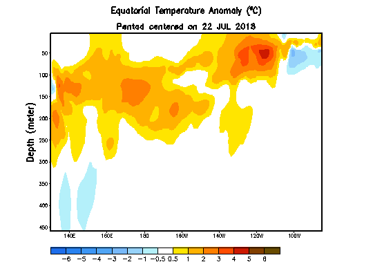
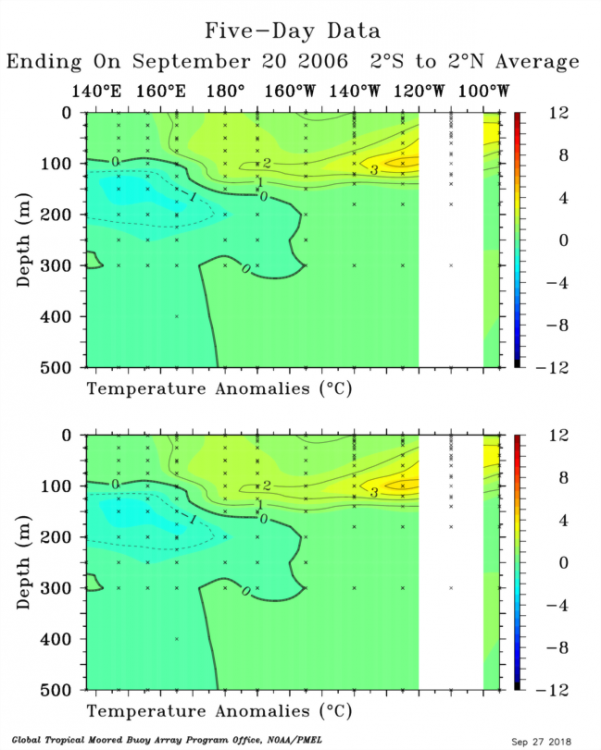
3 hours ago, ORH_wxman said:
The subsurface data is strongly favoring modoki/west-based El Nino at this point. If you compare with the same period in 2006, you can clearly see how 2006 was going to become more classic with time with all the subsurface warmth further east.
Sounds good, but what are your thoughts on this regarding a full basin event? I came across this today. ( below )
I myslef do not buy that, but I would think the El Nino could become a hair more robust, but still be West-Based / Modaki in nature.
-
3 hours ago, griteater said:
We speculate on here about winter, and some write winter outlooks, etc., but in the real world, are there companies that actually make use of winter outlooks? I would assume that they are used for energy market trading...and I would assume that, say, outdoor clothing companies (e.g. North Face) could make use of winter outlooks in preparing for supply & demand. Anyway, I'm just speculating. I was wondering if anyone could share info beyond speculation on this topic. Thanks.
Long range weather projects is a huge market for many public and private companies.
I read a report on the Wall Street Journal it is a growing field. Short term but, longterm outlooks guide decisions about inventory, commodities, the futures markets, what to makwe on the assembly lines and beyond that retailers, and what to focus on and how much, beyond that even more such as chemicals and other compunds. Knowing ahead in weather is a big market.
-
1
-
-
In regards tp the last post , here is Amy's post from the 25 th .
Honestly, I was not aware it was that weak last year during the Fall Season . I wonder if that had set the stage for the later season SSWE that took place. I know and we had discusssed last Jan and Feb there are precursors to SSWE that lend some insights.
I also read that at this time , very early in the season, you can not really tell how the PV will progress down the road. I think we need to be deeper into the cold season to make educated forecasts and assumptions.
-
Interesting to say the least.
-
17 minutes ago, 40/70 Benchmark said:
Looks a bit more decidedly modoki than 2006, too.
Ray, does the large area of subsurface warmth increase the possibility this could go to a moderate level , or is that simply wishcasting?


October 2018 Discussions & Observations Thread
in New York City Metro
Posted
Well, even though you said it is too early to tell, it would seem if you enjoy snow then we better get come cool, wet weather ASAP.
Of course on the flip side, maybe it is not possible any longer to depend on other winter seasons any longer as a forecast tools, because of global weather changes the last two decades.