

frd
-
Posts
6,511 -
Joined
-
Last visited
Content Type
Profiles
Blogs
Forums
American Weather
Media Demo
Store
Gallery
Posts posted by frd
-
-
2 hours ago, Interstate said:
The GFS we finally clear out on July 26th
Signs of a WNW or NW wind and cooler, maybe for 48 hours, as we near the end of the month. Another heatwave in the works for next week.
-
 1
1
-
-
1 hour ago, Interstate said:
Do I actually dare to say it feels nice out
Nice breeze currently, and in the shade not bad at all.
-
Appears the forecast for tomorrow has improved. Mount Holly NWS going with mostly sunny weather here and 89 with a light East wind. Would be a good day for lawn care and garden activities in the morning before hitting that high later in the afternoon.
The next oppurtunity for mostly sunny weather is not until next Thursday, between those days expect additional rainfall.
.gif.f204e2e13d0987f1f99fbb7d7c8bbecf.gif)
-
 2
2
-
-
-
-
Small cell just passed over Middletown where I am and it is pouring. I cannot recall in recent memory the consistency of rainfall the past 30 to 60 days after an extended period of dryness
-
3 minutes ago, dailylurker said:
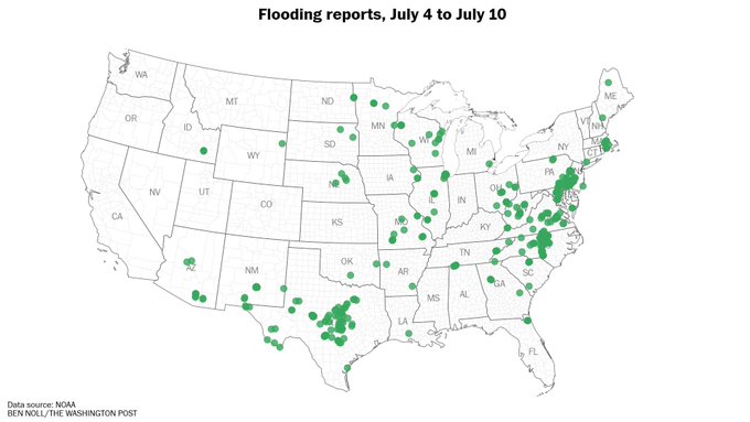
Man.. what a day it was yesterday. I ended with 3.50". Lots of flooding.
A very active day indeed.
I located this report as an example below, but many stations with 3, 4, 5 inches or more of rain over several days .
BRANDYWINE CREEK AT CHADDS FORDProvider:HADSPrecipitation Accumulation ValidTotal:5.68 in.Starting:7/7/2025 8:00 AM EDTEnding:7/10/2025 7:30 AM EDT-
 1
1
-
-
There was definitely a radar indicated hook presentation on radar with a thunderstorm Southwest of Middletown this evening that then prompted the national weather service to issue a tornado warning. I'm not exactly sure the outcome of this, but it looked really cool on the radar until I started to unwind
-
Tonight's storm was a more productive rainfall maker than last night for sure. Measuring over 1 in of rain, however not far from here in Claymont Delaware the rainfall total is 2.95 " on its way to 3 " with flash flooding.
-
Crazy storm here
Tornado Warning issued July 9 at 8:46PM EDT until July 9 at 9:15PM EDT by NWS Mount Holly NJTORPHI The National Weather Service in Mount Holly NJ has issued a * Tornado Warning for... Southwestern New Castle County in northern Delaware... Northeastern Kent County in northeastern Maryland... * Until 915 PM EDT. * At 845 PM EDT, a severe thunderstorm capable of producing a tornado was located over Delaney Corner, or 10 miles south of Middletown, moving northeast at 20 mph. HAZARD...Tornado. SOURCE...Radar indicated rotation. IMPACT...Flying debris will be dangerous to those caught without shelter. Mobile homes will be damaged or destroyed. Damage to roofs, windows, and vehicles will occur. Tree damage is likely. * Locations impacted include... Middletown, Massey, Delaney Corner, and Townsend.Instructions
TAKE COVER NOW! Move to a basement or an interior room on the lowest floor of a sturdy building. Avoid windows. If you are outdoors, in a mobile home, or in a vehicle, move to the closest substantial shelter and protect yourself from flying debris. Tornadoes are extremely difficult to see and confirm at night. Do not wait to see or hear the tornado. TAKE COVER NOW! Torrential rainfall is occurring with this storm, and may lead to flash flooding. Do not drive your vehicle through flooded roadways.-
1
-
-
2 minutes ago, dailylurker said:
It feel a lot better today than yesterday. Not as good if you are expecting severe storms and flooding imo. This feel like an average summer day.
Believe I saw a tornado warning in WV. Storms are firing up in that area.
-
2
-
-
54 minutes ago, GramaxRefugee said:
Instinct tells me better heating potential than yesterday. I look for stronger storms but less coverage. The NOAA says slight:
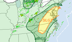
For my area, and in general, Mount Holly has four times the rainfall potential amounts for later today, verus last evening, interesting.
@WxUSAF posted about this yesterday, as well as @CAPE. WPC remains bullish next 72 hours as well.
.gif.4010296595b4a8a5de6a8e6ed8152182.gif)
-
Clear skies for a bit today.
-
4
-
-
DP a little lower this morning despite the steam effect from all the rain.
DP at 73 presently. Better dog walking weather this morning.
-
1
-
-
My rain gauge had an electronic issue and was not working for this storm to measure rainfall.
This NWS site link shows I only received .11 of rain from the two storms. I have a hard time with that because it poured here, granted the storm did not last long.
Anyone know how reliable this link is
https://www.weather.gov/phi/rainfall-monitoring
-
Little split going on here , experienced the gust front, but no rain yet, while ares to my North and Northest are getting hit hard.
-
17 minutes ago, CAPE said:
Looking at the radar now, you probably should be. Solid line of red heading your way.
Severe Thunderstorm Warning
DEC001-003-MDC011-029-035-082245- /O.NEW.KPHI.SV.W.0155.250708T2145Z-250708T2245Z/
BULLETIN - IMMEDIATE BROADCAST REQUESTED Severe Thunderstorm Warning National Weather Service Mount Holly NJ 545 PM EDT
Tue Jul 8 2025 The National Weather Service in Mount Holly NJ has issued a
* Severe Thunderstorm Warning for... New Castle County in northern Delaware... Northwestern Kent County in central Delaware... Queen Anne`s County in northeastern Maryland... Northwestern Caroline County in eastern Maryland... Kent County in northeastern Maryland...
* Until 645 PM EDT. * At 545 PM EDT, severe thunderstorms were located along a line extending from near Charlestown to 6 miles west of Newtown to near Gibson Island, moving east at 35 mph
. HAZARD...60 mph wind gusts. SOURCE...Radar indicated.
IMPACT...Damage to roofs, siding, trees, and power lines is possible.
* Locations impacted include... Wilmington, Newark, Middletown, Centerville, Elsmere, New Castle, Chestertown, Centreville, Clayton, Oakland, Delaware City, Ridgely, Rock Hall, Newport, Church Hill, Millington, Sudlersville, Betterton, Old Town, and Starr.
PRECAUTIONARY/PREPAREDNESS ACTIONS... For your protection move to an interior room on the lowest floor of a building. In addition to large hail and damaging winds, frequent cloud to ground lightning is occurring with these storms. Move indoors immediately. Remember, if you can hear thunder, you are close enough to be struck by lightning.
Torrential rainfall is occurring with these storms, and may lead to flash flooding.
Do not drive your vehicle through flooded roadways. && LAT...LON 3904 7631 3901 7628 3905 7623 3917 7628 3929 7617 3932 7618 3933 7614 3937 7611 3936 7588 3938 7577 3972 7579 3975 7576 3978 7545 3963 7556 3944 7555 3891 7589 3897 7620 3900 7617 3901 7619 3900 7632 TIME...MOT...LOC 2145Z 256DEG 30KT 3953 7602 3929 7626 3909 7638 HAIL THREAT...RADAR INDICATED MAX HAIL SIZE...<.75 IN WIND THREAT...RADAR INDICATED MAX WIND GUST...60 MPH $$ Staarmann
-
1
-
-
8 minutes ago, CAPE said:
Appears more uniform. We are going to score just a matter of time. Go WPC !!!
-
Just now, WxUSAF said:
I’m skeptical this raggedy ass line of storms is going to drop the 3.5” of rain WPC promised me this week
Me too

-
I am not enthused by the looks of things on radar, but hopefully this is reverse thought process and I get hit hard.
-
12 minutes ago, wxmeddler said:
The bay waters are are pushing 85+, the high dew points have not allowed ET off the surface to cool it. People are going to be talking about marine heat wave soon if this keeps up another few weeks.
The Med sea marine heatwave is nuts !
-
 1
1
-
 1
1
-
-
9 minutes ago, dailylurker said:
That depends on wind direction. Your best bet for seeing warm clear coastal waters is a NE wind.
Models don't seem that impressed with big rain later. I did notice the HRRR seems to have juiced up a little bit.
Could use the rain since the last few days have not been great in the rainfall department.
Storms are starting to fire in the far Western areas, however, with recent episodes of radar trickery and storms going poof and splitting I will take the same approach as in winter, don't measure the rain until its in the gauge.
-
1
-
-
Surf zone ocean temps continue to warm.
Many locations are at 75 to 76 degrees F. I think we might hit 78 to 80 degrees by early to mid August.
-
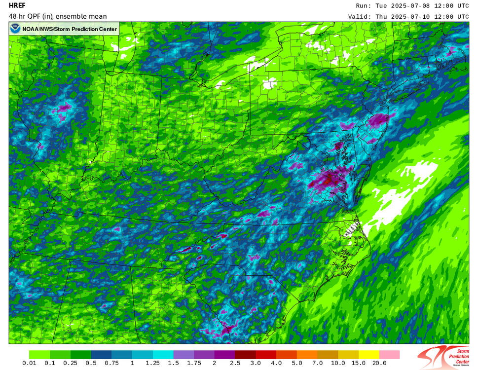
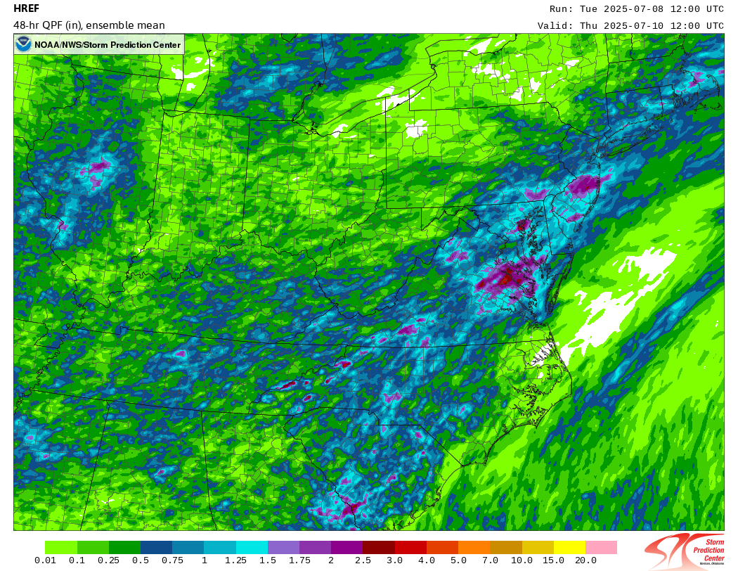
The next three days provides the majority of the WPC's 7 day rainfall totals.
Here is the day 1 to 3 rainfall outlook. Very robust prediction for excessive rainfall in our area.
.gif.85d12ad3d1be0fb34b2290090826da86.gif)
-
4
-


July Discobs 2025
in Mid Atlantic
Posted
Surf zone temps up again the last couple days.
Example - Today's North Wildwood sea temperature is
(Which is 4.7°F warmer than normal for this time of year)