frd
-
Posts
6,523 -
Joined
-
Last visited
Content Type
Profiles
Blogs
Forums
American Weather
Media Demo
Store
Gallery
Everything posted by frd
-
I am sure we go dry for the winter. But, rather active again, Friday now looking not so hot, and another system early next week. From Mt Holly AFD Thursday night/Friday: Guidance has come into better agreement that a weak coastal low will form Thursday night and pass sufficiently close to our area to warrant appreciable precipitation chances. Consequently raised PoPs a fair amount this package (they may need to be raised further in subsequent packages), but given that the low will be weak and fast-moving expect rainfall totals will be limited to a few tenths at most. By Friday afternoon cooler and drier air will filter in behind the low and expect rainfall to generally come to a quick end. Highs will likely only top out in the low to mid 60s in most locations. Saturday/Sunday: Dry and seasonably cool conditions will prevail through the weekend with daytime highs generally in the mid 60s and overnight lows in the low-mid 40s. Some frost will be possible in the colder spots of eastern PA Saturday but more- so Sunday morning as the radiational cooling setup looks fairly good (at least 5 days out) Monday: Another shortwave and associated area of low pressure may impact the area on Monday but details are fuzzy at this point, with the EC/CMC depicting a stronger system (and closer to the coast) relative to the GFS. Medium-range Chc. PoPs seem appropriate at the moment.
-
Me as well. Seems the WPC shifted ever so slightly the heaviest Rains to our East. By a hair, but better than deep red shades.
-
Did you notice the GFS it is trending more progressive as well. Meanwhile, the dews here are insane. My location is in the upper 60's, but other locations much higher. Very gross for almost October 1 st. Looking at the satellite time lapse just now and seeing the back edge of the cloud deck rapidly advancing to the NE. Should go partly to mostly sunny later . Humidity 93% Wind Speed S 8 mph Barometer 29.91 in (1012.6 mb) Dewpoint 66°F (19°C) Visibility 10.00 mi Last update 28 Sep 7:51 am EDT
-
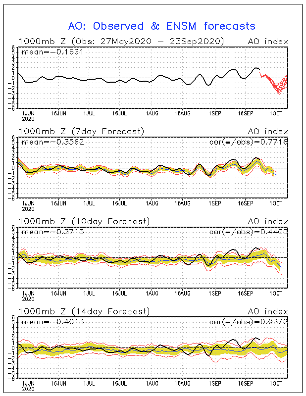
Another interesting reflection from grit regarding AO and the NAO both being negative ( .40 or lower ) during the period Dec to March since 1990.
-
From 430 AM to 630 AM. it really came down here. Really surprised by over .60 inch of rain. Seems as the norm, dryness does not last long, at least in this area. Glad to hear you are going to retire the sprinkler. Farewell my good friend.
-
Wasn't that the storm that Eastern areas went over to inches of sleet ? I had 12 to 14 inches of snow, then all sleet for hours and hours. Could have been 20 inches here had it not went over.
-
Simon just added this to his cool reference site. GEFS: 35-day 10 hPa 60°N The new GEFSv12 now features a 35-day run every day at 00Z. Shown here is the output from the previous day’s run, due to the time taken for the data to appear on NOMADS. Note that, because of the length of the forecast, systematic model biases are more likely to impact the output. These are not accounted for here.
-
Pac jet will not be denied.
-
Went to the beach recently and observed huge amounts of sand have been lost due to recent huge waves battering the surf zone from offshore hurricanes and the effect of the moon phase. Also, opposite of many past Septembers, the surf zone temps have really dropped off quickly.
-
Latest JMA evolves us from the chill at the end of September and early October to warmer pattern, pretty much everywhere, by Weeks 3 and 4. According to Ben, recent Ninas normally do not produce cold Octobers in the East.
-
WPC goes with higher QPF in latest update. ..Weather/Hazard Highlights... Ample energy seems set to dig into the potent upper trough/low position will push cold fronts across the central and eastern U.S. through the period and provide focus for rain. Amplification trends have slowed the eastward translation of a main lead front and reinforcement as contingent on uncertain stream separation. A significant WPC frontal continuity adjustment was applied to address timing. Modest to locally heavy rainfall totals may focus from the Appalachians eastward for the first part of the workweek, albeit with trough axis differences affecting wave development and moisture inflow potential.
-
Wondering about the Euro verification scores last few days. Heard East of the Mississippi it is not doing that hot recently during the past 30 to 45 days. Maybe the GFS goes for the win. I re seeded a little time ago. I don't need flash flooding again.
-
Seems in this new day and age, we tend not to stay dry for too long. That solution also looks to have severe implications for the South. A huge dive in the NAO and the AO coming up shortly, with a pretty good consensus that it verifies.
-
I read a couple posting from TIP that events in a general shotgun area of the NE can be more extreme, in the winter, for example ....I think the idea was a fast PAC flow all the time, but when we funnel that energy into an extreme low pressure area it slows and it becomes one for the ages. So to me that implies, and seems backed possible by the last 10 years, that we are getting more intense storms.
-
Granted the seasonal models, Glosea included, all have what appears to be a + NAO. Not as robust as last winter, but I place little faith in long range and medium range NAO domain outlooks. All about timing, etc. I look forward Tom's NAO outlook. I enjoy your insights as well.
-
Sample size is small and we would require a - NAO , especially in our region here for any hopes of significant snowfall. But, the idea of a poleward High during the winter and even extending into the EPO regions has been mentioned by a few pros and mets. Of course, as you know, being in a Nina combined with the location of the Northern Mid Atlantic will take some divine intervention for significant snowfall opportunities.
-
Will be interesting to track this, as well as the reliability of the model forecast. Many previous seasons have had poor forecasts focused on certain indices, ( NAO, AO, EPO, etc. ) including given biases. That is a very significant drop.
-
Great post by @bluewave this morning, I wanted to share it here. As mentioned in the post here, a very small sample size indeed, but still worth following to see what transpires with the Western Ridge during the month of October. I wonder if we enter a feedback loop and how the evolving Nina will effect long term Western ridging later in the year. Here is bluewaves's post: < The sample size for La Niña Octobers with a Western Ridge and Eastern Trough is very small. So we will have to see if the strong ridge to start the month persists like it has in September. There was only 1 La Niña year since 1950 with a pattern like this. It was October 1988. The dominant Pacific feature that winter was that the NEPAC ridge extended north into Alaska. Main problem for us in 88-89 was the very strong +NAO. 08-09 had an almost identical Pacific La Niña pattern with a better Atlantic and more snowfall. So maybe a strong ridge out West in October would be hinting that the Pacific Ridge will extend into Alaska.This would be unlike the last 2 winters with the flat La Niña Ridge North of Hawaii. But we would have to wait and see how the NAO evolves . Still too early to know if any of this pans out. Just something to think about. >
-
@CAPE Interesting
-
Speculation on my part that maybe the pattern is possibly showing a tendency for a different outcome at times during the winter regarding the North Pac ridge and Western ridging. Again not sure how things evolve as we get deeper into the Fall season. It seems the last 3 years were all November and EARLY December head fakes, as the real winter pattern did not take hold until post December 20th.
-
We are getting our winter now and in early October. By the way, Western fires are not the only location in the NH spewing aerosol and other elements into the atmosphere.
-
The Euro has not been that great recently, and I hate the weeklies ( flip flops and all ), but there is a general consensus for a possible average to below average October in these parts.
-
Not saying there is a correlation, someone needs to confirm, but the Northern Atlantic is crazy and wondering about wave breaking as the NAO is set to tank on some modeling and the AO is a going down too . Teddy producing some crazy winds and waves as well. Also, of interest , is the changing SST anomaly near the East Coast from the constant stream of swells and upwelling the past several weeks produced by the recent offshore hurricanes.
-
After the cold shot mentioned above, maybe a Gulf Hurricane.