WxUSAF
-
Posts
28,350 -
Joined
-
Last visited
Content Type
Profiles
Blogs
Forums
American Weather
Media Demo
Store
Gallery
Everything posted by WxUSAF
-
RGEM has that N-S oriented trough of warm air aloft like 12z euro.
-
Yeah quite possible. That said, if it’s borderline, still could work out. But the confluence and high shifting north don’t provide much confidence things can shift. Could also be a precip rate dependent deal. Heavier precip progs might be colder and vice versa. Things to watch.
-
Yeah, that’s why I was cautiously optimistic as the run developed. Then it just pushes warm air north with that trough. Maybe it’s real, maybe a fluke.
-
That inverted trough (trowal maybe?) is sort of the killer. Not sure how real that feature is. I actually though euro looked decent/good before it got to us.
-

Jan Medium/Long Range Disco: Winter is coming
WxUSAF replied to stormtracker's topic in Mid Atlantic
In happier news, GEFS has The Look starting MLK weekend. PV trapped under a mega -NAO/AO with some ridging developing out west. -
That’s basically what the Ukie was also
-
Then you’re in much better shape than the cities. I know the urban core of Towson can be warm though, so that’s something to watch as you get familiar with the microclimates in the area.
-
I’ve seen the option C in the ensemble mix (I think based on snow maps posted), but not sure any op run has pulled that out (yet). Ops seem to be switching between A and B or some blend between them. Let hope Euro can pull a B here…
-
It depends lol. And 95 is also close to, but not exactly the “fall line”. The fall line is the boundary between the coastal plain and the piedmont and elevation goes up between them. Your elevation and amount of urban heat island your particular location has is a big deal for snow totals in our area.
-
Yeah it really sped up. Even if some of the bigger totals that have been shown came to pass, not good timing for snow day hopefuls on Monday.
-
My snowboard is at 378.4251969 feet per the LiDAR map.
-
Looks qualitatively consistent with gfs and GGEM with a solid thump and then mixing dependent on location.
-
Jan Medium/Long Range Disco: Winter is coming
WxUSAF replied to stormtracker's topic in Mid Atlantic
Agreed. I’ll start the thread. In all honesty, the pattern is just super active starting this weekend. And there is arctic air nearby. Going to be a lot of precip either way I think. -
Jan Medium/Long Range Disco: Winter is coming
WxUSAF replied to stormtracker's topic in Mid Atlantic
GGEM has snow into the cities before the absolute deluge next week. Gfs is damn close also. Both are big hits for I81 corridor. -
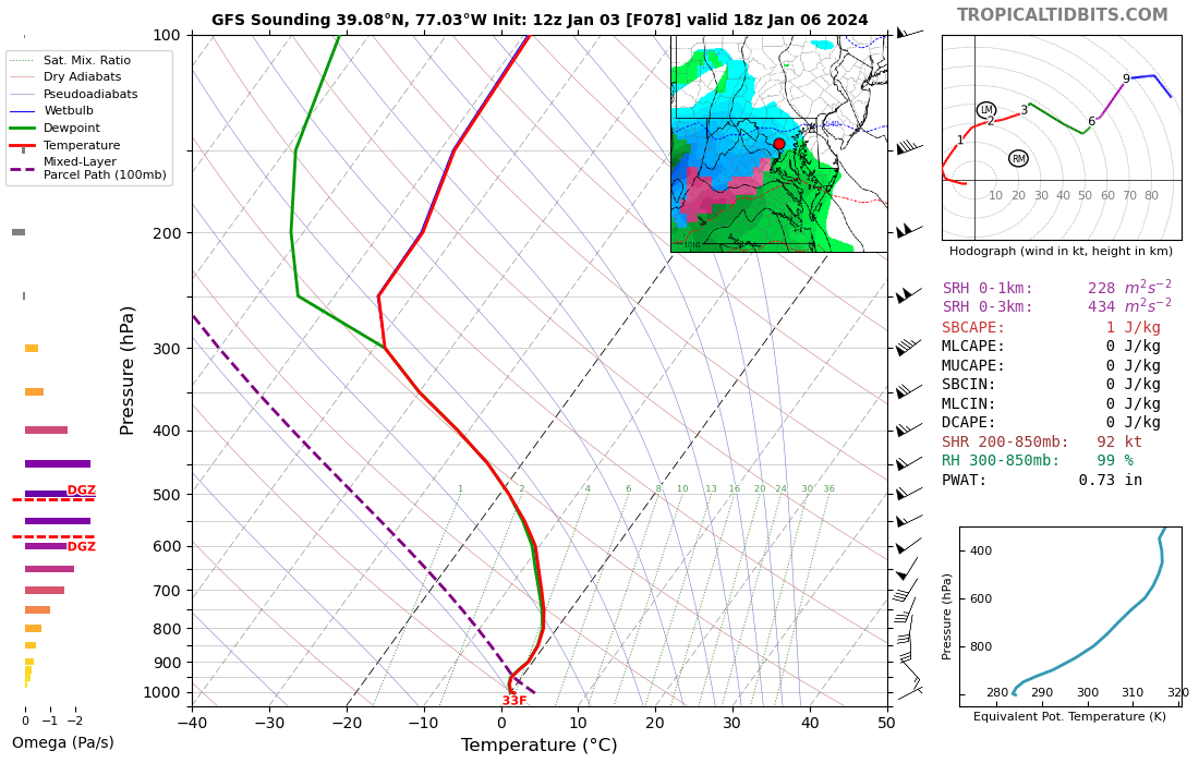
All the 12z guidance so far suggests the metro corridor and points N/W will really thump when the precipitation arrives. Your IMBY total will depend on ratios and how long you can hold the column. But if that GFS sounding is right, it’s puking fatties until the flip.
-
Dear lord that’s a brutal gradient. Going to be riots if that plays out.
-
GFS is interesting. It has a stronger vortmax in the plains and so I thought if would maybe follow 6z euro. And it does end up a bit stronger/norther, but the WAA thump is legit. You don’t get soundings like this often from the GFS. This is legit heavy snow for a few hours Saturday afternoon.
-
“There’s not going to be a snow day Monday” boom done
-
Yeah they usually are pretty simpatico, so I’d expect GGEM to be similar if maybe a little tamer overall.
-
Let’s not do this “it won’t accumulate” game for the 1081st time please. Could 10:1 be too high? Sure. But I will bet my retirement fund that if 10:1 shows 3-4” that falls in 6 hours, the snow depth won’t be 0.0”.
-
Oooohhh…that’s encouraging. Tossing 6z euro with extreme prejudice!
-
My quick look at 6z euro was that it jumped back to that “worst of both worlds” scenario from 6z/12z yesterday with a stronger vortmax and more phasing, but not enough to get back to that strong storm scenario from 48-72 hours ago. It was a fairly big jump from 0z. We’ll see what happens at 12z!
-
Good morning all, glad we came back overnight. I agree with something @Deck Pic said a few pages ago. Those of us in the metro corridor I think should be rooting for a big WAA thump in the 20-0z time period Saturday I think. Pile up some mashed potatoes quick and then it’s already dark by the time it flips to rain. And it’s probably all over before midnight Sunday.
-
If there’s been any real trend over the last 24-48 hours, I think it’s been away from a big phased system and toward a weaker southern wave sliding east alone. 18z gfs is the biggest step yet on that. That removes the big upside potential, but maybe allows us to get something respectable still?
-
Trend seems to be for all the green, yellow, and red spots to completely change positions?