WxUSAF
-
Posts
28,702 -
Joined
-
Last visited
Content Type
Profiles
Blogs
Forums
American Weather
Media Demo
Store
Gallery
Everything posted by WxUSAF
-

Jan/Early Feb Medium/Long Range Discussion Part 3
WxUSAF replied to WinterWxLuvr's topic in Mid Atlantic
-
Jan/Early Feb Medium/Long Range Discussion Part 3
WxUSAF replied to WinterWxLuvr's topic in Mid Atlantic
GFS is verbatim an example for Hoffman’s book with a perfect track at peak climo with a torched boundary layer.
-
Jan/Early Feb Medium/Long Range Discussion Part 3
WxUSAF replied to WinterWxLuvr's topic in Mid Atlantic
All 3 ensemble systems are consistent with pattern evolution the first few days of February. The big pac jet extension is very short-lived and it weakens after a couple days. Then the trough out west starts to undercut the ridge in the east and the ridging rotates north and west across the continent. Keep this rolling forward a few more days and the reds and blues are mostly in the right places. Now do we need 7-10 more days to recharge cold air sources at peak climo? TBD, but I think it’s faster than that despite elephants and BAMwx flame emojis.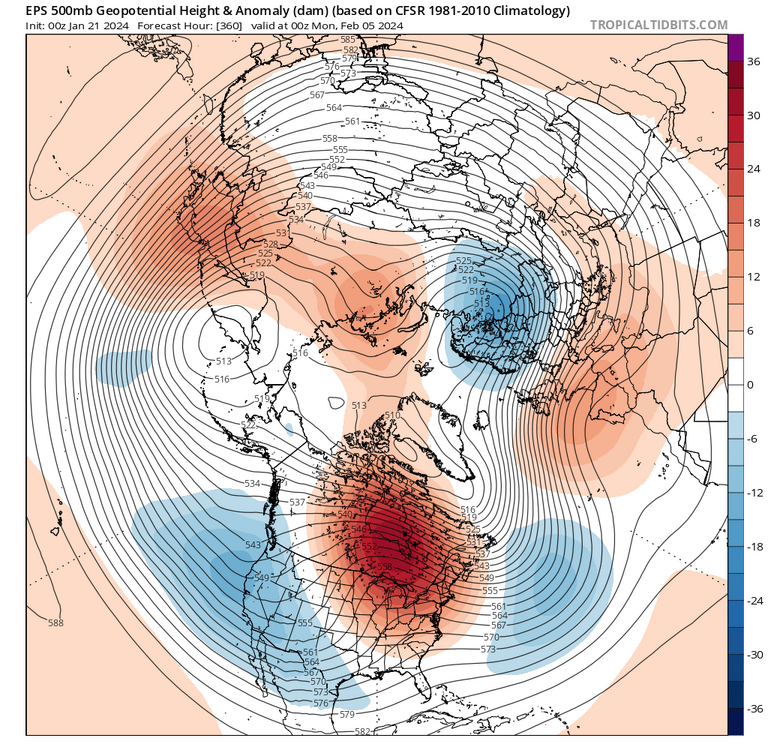
-
Low of 16, 20 currently
-
Jan/Early Feb Medium/Long Range Discussion Part 3
WxUSAF replied to WinterWxLuvr's topic in Mid Atlantic
I had that as a kid!! -
Jan/Early Feb Medium/Long Range Discussion Part 3
WxUSAF replied to WinterWxLuvr's topic in Mid Atlantic
My son’s birthday is V-day and I promised him snow for it back in like October. Sooo…need something to happen by then. -
This is the difference this year with Monken. Opposing defenses can slow them down for a time, but not the whole game.
-
Reset seems to have worked
-
Sheesh../offense needs a reset
-
Ravens receivers are not getting open for Lamar. He’s extending time and he isn’t finding them downfield which happened so much during the season.
-
Enough snow blowing off my roof that I can probably measure a few tenths new snow on my snowboard
-
Jan/Early Feb Medium/Long Range Discussion Part 3
WxUSAF replied to WinterWxLuvr's topic in Mid Atlantic
I mean, that’s the peak of peak climo, so if we can get some fluke amidst an otherwise bad pattern, that’s the time for it to happen. Messy/mixed/flawed events are a normal part of climo for us! 2” that gets washed away, tail end slop following a rainer like December…they’re not glamorous, but that’s how we get to climo most times it happens. -
Jan/Early Feb Medium/Long Range Discussion Part 3
WxUSAF replied to WinterWxLuvr's topic in Mid Atlantic
Gun to head, I think we get another 7-10 day period that has a small event on the front and a MECS-scale event in the back, although maybe with more mixing in the metros than we’d prefer. Then another 1-2 smallish events after into the first 2 weeks of March. If it played out like that, most of us would be 100-125% of climo. -
This is the first time I can remember an inverted trough verifying *south* of its modeled position. They are notorious for showing up north of guidance. Although I don’t have the photographic memory of our snow fails like others on here.
-
Mid-Atlantic Snow Totals Thread - Winter 2023-2024
WxUSAF replied to mattie g's topic in Mid Atlantic
January 19, 2024: 5.4” total: 10.9” basically exactly 50% of climo -
Low of 14. Go Ravens!
-
Jan/Early Feb Medium/Long Range Discussion Part 3
WxUSAF replied to WinterWxLuvr's topic in Mid Atlantic
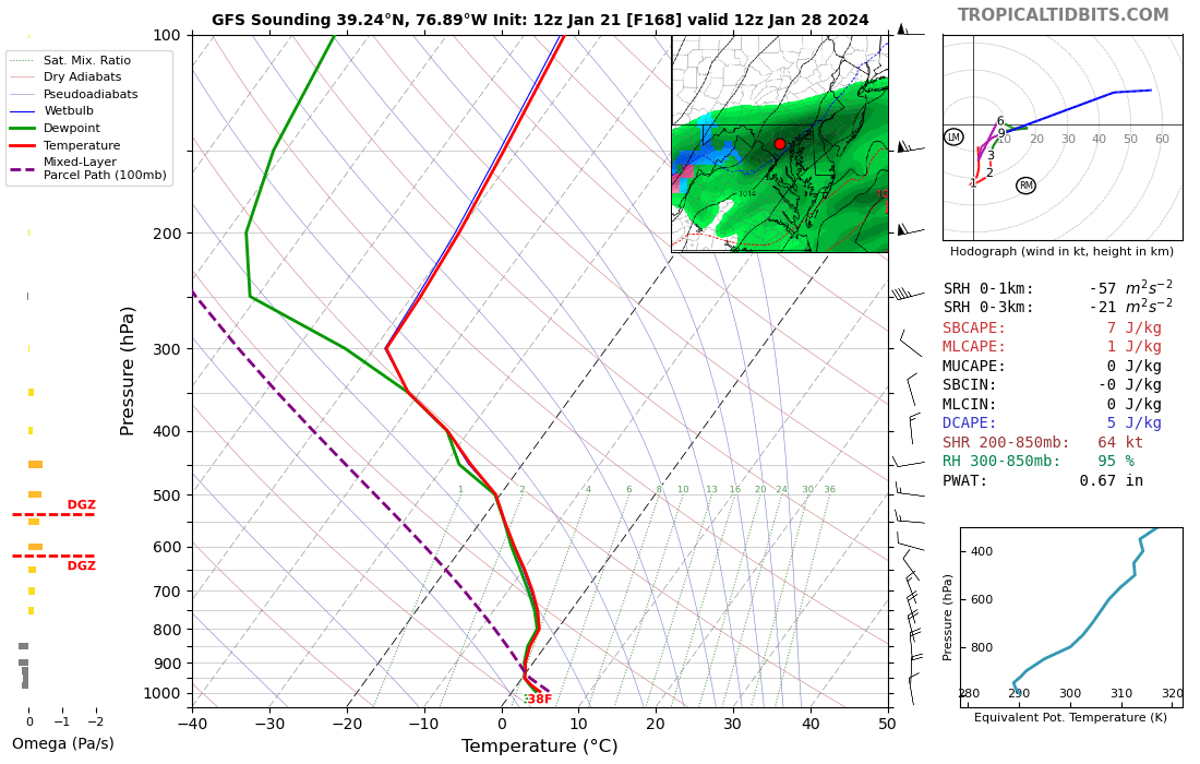
Goofy ass evolution that will never happen, but 6z gfs gets it done Jan 30-31 -
Cheers weenies, we did it

-
LWX definitely got a bit overzealous with that 5-8” update. 3-5/4-6” seems like the reality for most of that zone.
-
5.4”, 0.1” last hour. That looks like it pending streamers. Sun peaking through even it is still snowing very lightly.
-
It’s definitely winding down, but still slowly adding up. Let’s see if we can get in on those streamers.
-
5.3”, 0.2” last hour. Light snizzle.
-
5.1” total, 0.2” last hour. Warning verified! Crazy. Basically pixie dust/snizzle now. 31F.
-
4.9”, 0.5” again last hour. I’ve beaten the early week storm which seemed crazy as of yesterday. Still snowing well.
-
4.4”, 0.5” last hour