Cfa
-
Posts
4,693 -
Joined
-
Last visited
Content Type
Profiles
Blogs
Forums
American Weather
Media Demo
Store
Gallery
Everything posted by Cfa
-
 99, 103, 102. Almost 3 consecutive triple digit days.
 -
Lightning from the storm out in the Atlantic is visible all the way from the north shore of LI, I initially thought it was much closer.
-
Seabreeze is only good for thunderstorms, sometimes.
-
100. I wasn’t expecting that, but then again we were running slightly warmer than yesterday this morning.
-
“In New York City, the temperature fell just shy of hitting triple digits, but the high of 99 degrees was still enough to beat the previous daily record for the date, surpassing the high of 96 degrees set on June 24, 1888. Some areas not far from Central Park, where the official weather observations for the city are taken, did manage to hit 100 degrees, including Newark (103) and John F. Kennedy International Airport (102).” https://www.accuweather.com/en/weather-news/philly-boston-hit-100-nyc-breaks-record-from-1888-amid-heat-wave/1787130?partner=web_grailr_adc That’s a lot of unnecessary verbiage to contradict the first statement. JFK, LGA, JRB, and the entire micronet just don’t exist in New York City, I suppose.
-
Already 90 here, yesterday at this time it was 89.
-
Same. Feels sort of nice without getting blasted by the sun at its peak angle.
-
July 22, 2011 is my personal all-time highest at 105, I lived in Queens though. Today’s 103 is highest for Long Island, first triple digit high after reaching 99 multiple times.
-
103 now.
-
I hate how Central Park gets treated as if it’s NYC’s Blue Hill Observatory. If it’s not going to be fixed then I’d prefer it be shut down.
-
Car reading 106 on Sunrise Highway in Bay Shore.
-
Yesterday felt more intense to me, this is honestly tolerable. I’ll take today over the cloudy grey slop regime we just got out of.
-
101 now.
-
And isn’t the Queens College mesonet on a roof? (I wish it was there in Sept 2010 during the tornado/macroburst).
-
Up to 98 now, ahead of yesterday at this time, today’s low of 72 was cooler than yesterday’s, so it’s interesting that today is already hotter. Don’t think I’ve ever seen 100 degree conditions after a low in the low 70’s. But in my experience, anytime it’s been this hot around 10 AM the ceiling has been higher than 100.
-
I was outside of ISP about 30 minutes ago and it was already 86, it was actually cooler on the north shore, my PWS was still in the upper 70’s at that time. Normally the opposite.
-
79/75 here.
-
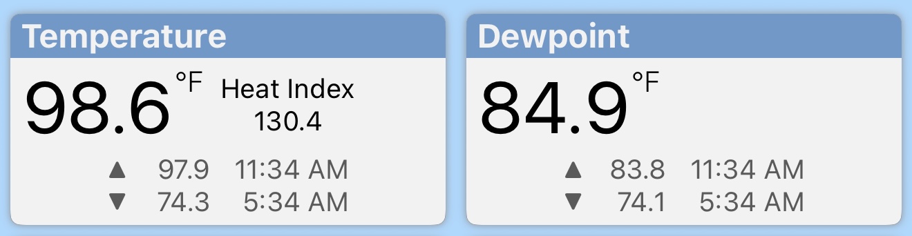
Heat Index peaked at 130 during the seabreeze temp/humidity spike earlier. That spike happened so fast that the high temp/dew point hadn’t even updated yet in the app.

-
I think there’s a little downsloping at play here too, I’m north of the terminal moraine which is over 300 feet in elevation, I know it’s nothing compared to other parts of the region, but what goes up must come down.
-
I hope so lol. That and it’s a Tuesday.
-
Down to 96 already. High of 99. What a rush though lol. Heat index still high but that was nuts for a few minutes.
-
99!!! Seabreeze might do it! Heat Index in the 120’s right now. Highest ever for my PWS.
-
I’m north of NY25 lol. Used to be close enough to the LIE to hear it though.
-
Up to 96 now, sea breeze still a few miles south, hope it stalls out a bit, looks like it’s slowed down a bit.