Tyler Penland
-
Posts
2,527 -
Joined
-
Last visited
Content Type
Profiles
Blogs
Forums
American Weather
Media Demo
Store
Gallery
Everything posted by Tyler Penland
-

2025-2026 Fall/Winter Mountain Thread
Tyler Penland replied to Buckethead's topic in Southeastern States
Just heard snow has started in Banner Elk. Here we go.... -
2025-2026 Fall/Winter Mountain Thread
Tyler Penland replied to Buckethead's topic in Southeastern States
Kinda lost in all this but there is a very real chance Charleston sets their all time low 500mb heights with this storm. NAM drops to 522dam their current record is 527dam from 12/13/2010. -
2025-2026 Fall/Winter Mountain Thread
Tyler Penland replied to Buckethead's topic in Southeastern States
So... Saturday and Sunday. Got it. LOL The Warning alone has that criteria in it- 4-7" of snow plus sustained 35, gusts to 60. From the AFD That said, conditions will remain hazardous due to the amount of wind that is being forecast. As the storm deepens along the coast expected winds to increase areawide Saturday night into Sunday with wind gusts ranging from 40 mph in the piedmont to as much as 60 mph across the mountain ridges. This will result in considerable blowing and drifting snow. All of the snow that falls will be falling on a layer of ice (the compacted snow and sleet of the previous storm). Due to the lack of friction, all of the new snow will become available to blow with the wind... which means there will be a lot of drifting and roads being inundated from wind swept snow. -
2025-2026 Fall/Winter Mountain Thread
Tyler Penland replied to Buckethead's topic in Southeastern States
Anybody know what Blacksburg's requirements for a Blizzard Warning are? With the wind/rates/white out conditions under the ULL I could see those being reached. -
2025-2026 Fall/Winter Mountain Thread
Tyler Penland replied to Buckethead's topic in Southeastern States
Euro also spitting out some absolutely ridiculous windchills Sunday morning. -
2025-2026 Fall/Winter Mountain Thread
Tyler Penland replied to Buckethead's topic in Southeastern States
I don't know what's going on but this is the second night in a row I've had house-shaking wind roaring down the holler. Wild and weird. -
2025-2026 Fall/Winter Mountain Thread
Tyler Penland replied to Buckethead's topic in Southeastern States
-
2025-2026 Fall/Winter Mountain Thread
Tyler Penland replied to Buckethead's topic in Southeastern States
It did an excellent job with the CAD over the weekend. Not sure how that translates but its the best model Canada puts out for sure LOL -
2025-2026 Fall/Winter Mountain Thread
Tyler Penland replied to Buckethead's topic in Southeastern States
6/10"+ QPF for the northern mountains. If things hold I wouldn't be surprised if the Smokies get smoked (haha) with a couple feet up high. -
2025-2026 Fall/Winter Mountain Thread
Tyler Penland replied to Buckethead's topic in Southeastern States
Yeah it's WINDY here. Some of the strongest surface gusts I've had since Helene in the hole here. It's really hard for wind to hit the surface where we are in the holler but it sure is tonight. Sent from my Pixel 10 Pro using Tapatalk -
2025-2026 Fall/Winter Mountain Thread
Tyler Penland replied to Buckethead's topic in Southeastern States
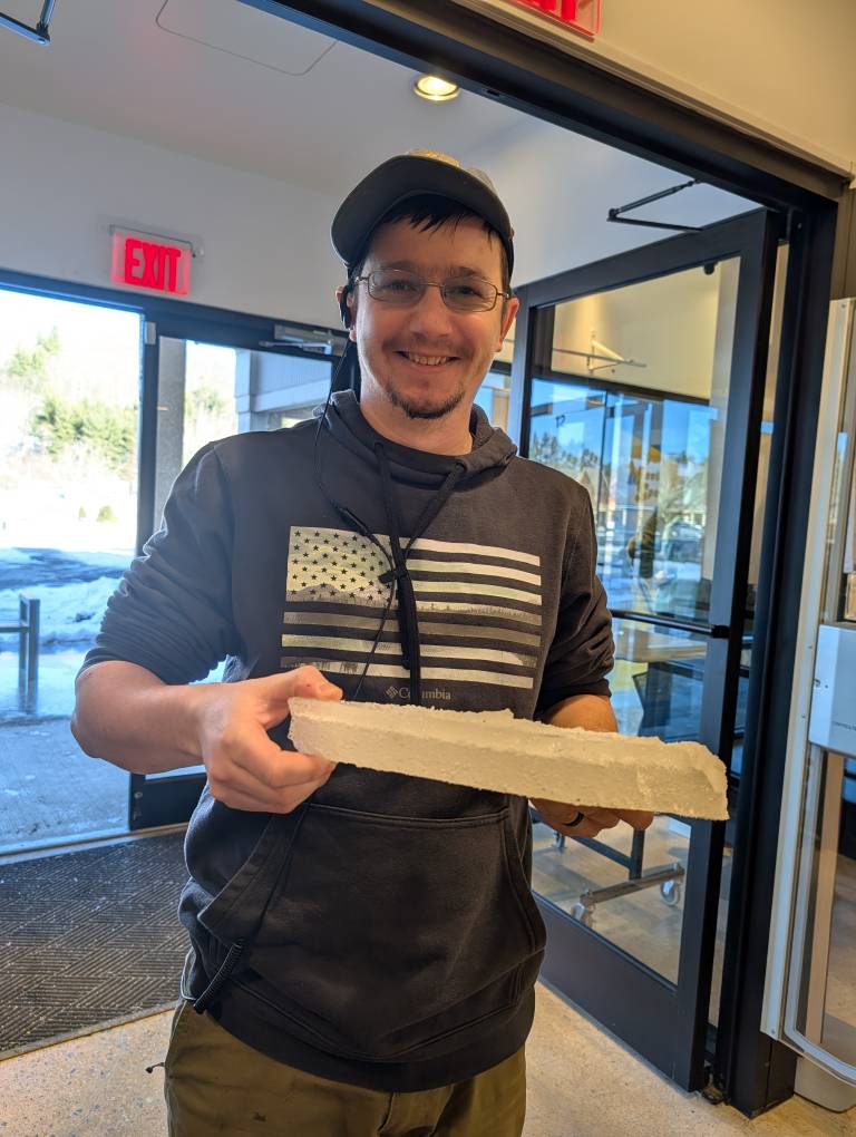
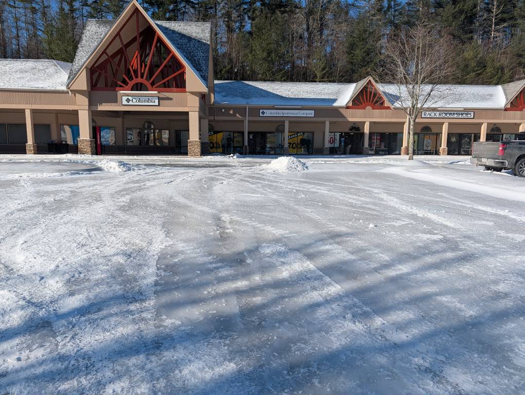
Couple photos from the store today. The lot looks like all of them in Blowing Rock - a solid sheet of ice. They managed to get some busted up so I could share how thick it is. Sent from my Pixel 10 Pro using Tapatalk

-
2025-2026 Fall/Winter Mountain Thread
Tyler Penland replied to Buckethead's topic in Southeastern States
3.9º for a low at the house this morning. Temperature shot up to 17º by 8AM, though, which was kinda weird. -
2025-2026 Fall/Winter Mountain Thread
Tyler Penland replied to Buckethead's topic in Southeastern States
We saw this song and dance a couple weeks ago. Later phase by the Euro won. -
2025-2026 Fall/Winter Mountain Thread
Tyler Penland replied to Buckethead's topic in Southeastern States
Just dipped to 9.5. About an inch-ish of powder today but white out conditions many times. Store was closed today, not sure about tomorrow. All the parking lots in Blowing Rock are about 1-1.5" of compressed sleet/slush turned into ice. Could ice skate around easier than drive. -
2025-2026 Fall/Winter Mountain Thread
Tyler Penland replied to Buckethead's topic in Southeastern States
The GFS gets a failing grade just for missing precip amounts so badly. Globals weren't even close, which is fascinating to me but oh well. And Hunter, if I see maps floating around FB of this next storm I might lose my mind. SUNSHINE SUNSHINE SUNSHINE I need a break. -
2025-2026 Fall/Winter Mountain Thread
Tyler Penland replied to Buckethead's topic in Southeastern States
Eh, just ignore them. They're the same group of people that would complain if they got more than forecasted. If 15 years of social media weather and retail have taught me anything its that the dumbest people are the loudest. -
2025-2026 Fall/Winter Mountain Thread
Tyler Penland replied to Buckethead's topic in Southeastern States
Fell back to 35°. It's 27 on several stations literally a quarter mile down the hill. Very windy right here in the first couple hundred feet above the wedge. Sent from my Pixel 10 Pro using Tapatalk -
2025-2026 Fall/Winter Mountain Thread
Tyler Penland replied to Buckethead's topic in Southeastern States
You'll get yours with NWFS tonight/tomorrow. Sent from my Pixel 10 Pro using Tapatalk -
2025-2026 Fall/Winter Mountain Thread
Tyler Penland replied to Buckethead's topic in Southeastern States
Cranked it up to 36º in the last few hours. Got a lovely inch of slush that will be a blast when it refreezes- probably go shovel it off the driveway if it doesn't melt later. Went up like a rocket when the wedge broke. Meanwhile it is still 20/21 in Boone and Blowing Rock. -
2025-2026 Fall/Winter Mountain Thread
Tyler Penland replied to Buckethead's topic in Southeastern States
Still at 17.1 but I can hear the wind up above me now. Little breeze making it to the ground. Light/moderate sleet with ZR mixing in. Where we are we should warm close to or above freezing by lunch-ish tomorrow. Eastern side of the county won't be so lucky. -
Southern Crippler - Get well soon Jimbo Storm Obs
Tyler Penland replied to BooneWX's topic in Southeastern States
Temperature has been in free fall southwest of Boone. Been stalled at 17.1/15.4 for about 20 min. Steady sleet/zr everything is slick as owl snot out there. Sent from my Pixel 10 Pro using Tapatalk -
2025-2026 Fall/Winter Mountain Thread
Tyler Penland replied to Buckethead's topic in Southeastern States
Holy cow guys this wedge is wild. Temp still in free fall down to 17.8/15.8 with mix of sleet/ZR. Sent from my Pixel 10 Pro using Tapatalk -
2025-2026 Fall/Winter Mountain Thread
Tyler Penland replied to Buckethead's topic in Southeastern States
Down to 19.8/17.8 here so column just about fully moistened up. Still light sleet for the time being. Backroads were slick AF on my drive home. -
2025-2026 Fall/Winter Mountain Thread
Tyler Penland replied to Buckethead's topic in Southeastern States
Over to sleet here now. It was fun while it lasted. Sent from my Pixel 10 Pro using Tapatalk
-
2025-2026 Fall/Winter Mountain Thread
Tyler Penland replied to Buckethead's topic in Southeastern States
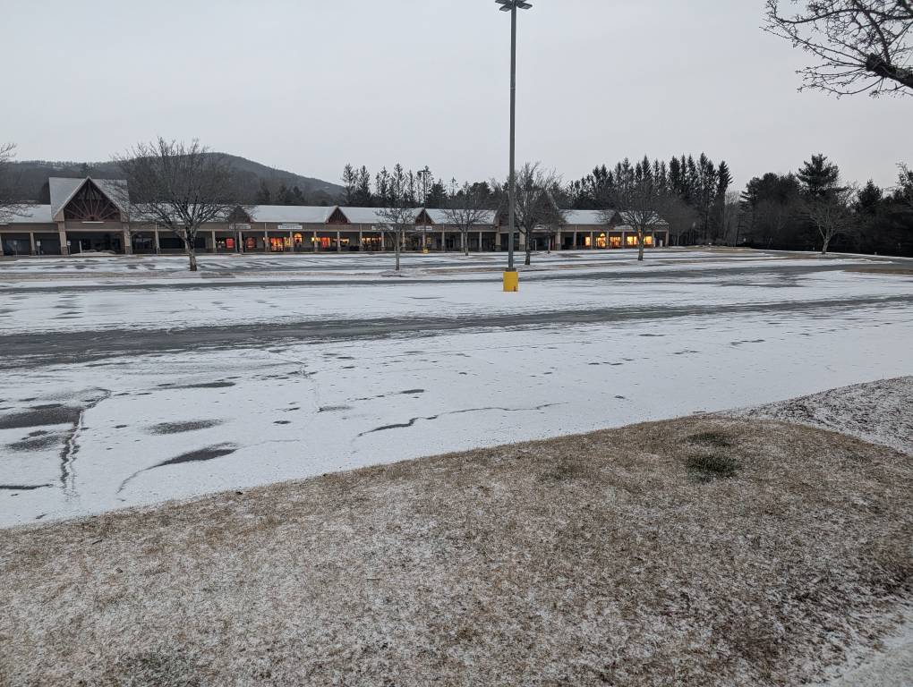
Ground/parking lot/cars covered here. I'd imagine roads aren't far behind with limited traffic and temp down to 18.