Tyler Penland
-
Posts
2,526 -
Joined
-
Last visited
About Tyler Penland

- Birthday 11/15/1991
Recent Profile Visitors


-

2026 Spring/Summer Mountain Thread
Tyler Penland replied to Buckethead's topic in Southeastern States
It looks fake. Not saying there wasn't a funnel (there almost definitely was), but I doubt it looked like that. -
2026 Spring/Summer Mountain Thread
Tyler Penland replied to Buckethead's topic in Southeastern States
Saw a photo of what appeared to be a lowered mesocyclone from a drone shot in Asheville but hard to tell for sure not great quality. Sent from my Pixel 10 Pro using Tapatalk -
2026 Spring/Summer Mountain Thread
Tyler Penland replied to Buckethead's topic in Southeastern States
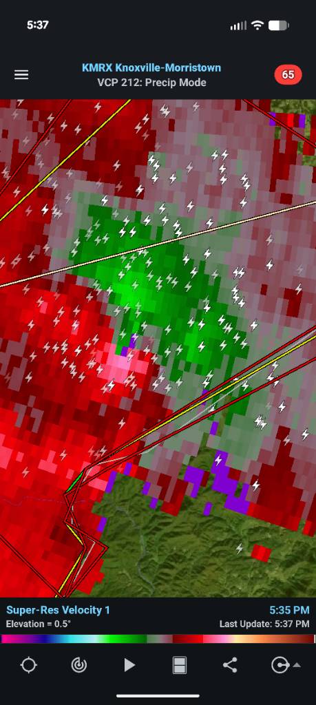
Geez that cell near Bucket head is wrapped up. Sent from my Pixel 10 Pro using Tapatalk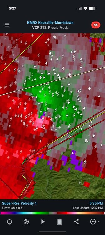
-
2026 Spring/Summer Mountain Thread
Tyler Penland replied to Buckethead's topic in Southeastern States
Aight one day of heat back and I'm already over it. Bring on fall/winter. Heading to the North Wilkesboro races this weekend and the trucks are at 12:30 on Saturday afternoon. -
2026 Spring/Summer Mountain Thread
Tyler Penland replied to Buckethead's topic in Southeastern States
My station made it to 90.5 this afternoon. As far as I can remember that's the first time I've ever recorded a high above 90 here at the house. Yesterday was 89.3. Sent from my Pixel 10 Pro using Tapatalk -
2026 Spring/Summer Mountain Thread
Tyler Penland replied to Buckethead's topic in Southeastern States
We managed to hit 42.1º this morning. Much cooler than I expected. The station right below me directly on the river hit 40.3º. Wild. I was hiking up at Grayson Highlands yesterday and it was in the mid-40s all evening. Definitely an odd, but very nice day out for early June. -
2026 Spring/Summer Mountain Thread
Tyler Penland replied to Buckethead's topic in Southeastern States
Only dropped to 35.6º last night. My wife's raised bed vegetables are thankful. -
2026 Spring/Summer Mountain Thread
Tyler Penland replied to Buckethead's topic in Southeastern States
Low of 31.6º this morning. Been enjoying the cool temps. Looks like finally some legitimate rain this weekend- we need some or spring flower season is going to suck. -
2026 Spring/Summer Mountain Thread
Tyler Penland replied to Buckethead's topic in Southeastern States
0.06" overnight- bottomed out at 37º this morning. Saw some reports of flurries around but never saw any myself here at the house. -
2026 Spring/Summer Mountain Thread
Tyler Penland replied to Buckethead's topic in Southeastern States
I managed a grand total of 0.01" overnight last night. Just enough to make the truck look even worse dirty. -
2025-2026 Fall/Winter Mountain Thread
Tyler Penland replied to Buckethead's topic in Southeastern States
Hard to argue with how this winter went, although I certainly would've liked to have seen more than 5" at a time. I ended the year with right at 20", pretty solid and right on average. I've seen plenty of below-average winters since moving up here so an average year is a win for me. That absolutely gorgeous December snow also gives a boost. -
2025-2026 Fall/Winter Mountain Thread
Tyler Penland replied to Buckethead's topic in Southeastern States
Just rolled into Daytona, heading down for the (hopeful) Artemis launch tomorrow. I always, and I mean every single time, forget how miserable the humidity is once you get south of the NC line. Brutal. -
2025-2026 Fall/Winter Mountain Thread
Tyler Penland replied to Buckethead's topic in Southeastern States
We must've gotten under a nice band overnight because I went to bed at 1/2" and woke up to a solid 3". Very nice surprise! -
2025-2026 Fall/Winter Mountain Thread
Tyler Penland replied to Buckethead's topic in Southeastern States
Starting to cover the grass here in Blowing Rock now. Took forever to switch over but hammering now. -
2025-2026 Fall/Winter Mountain Thread
Tyler Penland replied to Buckethead's topic in Southeastern States
Webcams show switch to snow in Boone. Still rain here in Blowing Rock but I suspect for not much longer