


Jackstraw
-
Posts
2,617 -
Joined
-
Last visited
Content Type
Profiles
Blogs
Forums
American Weather
Media Demo
Store
Gallery
Everything posted by Jackstraw
-

Winter 2020/2021 Short Range Discussion
Jackstraw replied to Chicago Storm's topic in Lakes/Ohio Valley
Started rip city here about 15 min ago... for 5 min. Have half dollar raindrops mixing in now. Also looks like I'm gonna get dry slotted by an 8th grade punk system. Gonna lay my watermelon in some Easter hay and watch the rest of the new Zappa doc. (Highly recommended btw) Let the Shakespearean Tragedy continue . -
Winter 2020-21 Medium/Long Range Discussion
Jackstraw replied to Hoosier's topic in Lakes/Ohio Valley
What's a clipper -
Winter 2020/2021 Short Range Discussion
Jackstraw replied to Chicago Storm's topic in Lakes/Ohio Valley
Report from Monticello IL of 8in, 6 from Argenta and Mt. Zion all within the last hour. Friend 20 miles N of me said it started ripping about 15 min ago.. As a bitching note, all these websites moving to graphical phone friendly designs for their sites suck. -
Winter 2020/2021 Short Range Discussion
Jackstraw replied to Chicago Storm's topic in Lakes/Ohio Valley
Baby Kanuk nailed the snow around Champaign at 00Z if it comes to fruition. Have some low/mid level dry air issues in IN but as the UL moves ENE should ring those out in the next hour.. Possible defo zone setting up from around Danville Il. up through Marion IN. -SN here, probably reach my 2in forecast for temporary relief from mudpocalypse. Points just to my N, especially IWX, are still in the game for an over performer. -
Winter 2020/2021 Short Range Discussion
Jackstraw replied to Chicago Storm's topic in Lakes/Ohio Valley
IWX 7pm update .Update... Issued at 717 PM EST Sat Jan 2 2021 Trends in near term guidance along with upstream sat/radar depiction of vigorous sw disturbance and attendant baroclinic leaf lifting out of nrn AR and expansion of radar returns through cntrl TN/wrn KY along leading edge of return moisture plume. This portents a brief period of mod-hvy snow likely to develop after midnight. Some nw displacement of H7 dilatation axis also noted in model guidance and suspect a robust deformation response aloft will occur overhead for a time late tonight. Thus have backed prior gridded stripe of higher qpf a bit nwwd esp under the guise of related H7 pivot point shaping up further nw from prior. Otherwise with a period of low static stability aloft timed with wwd arching but brief trowal, some banded enhancement likely which may yield some over performance in snow amounts northeast. Regardless rapid newd progression of upper sys lends a risk of going any higher with top end snow probs even though they may verify correct in some locations far northeast. Otherwise primarily a snow event with drizzle persisting this evening before ice nucleation takes over with arrival of upstream mid level moisture slug. -
Woke up to a nice fluffy 4. Finally looks like winter out
-
Who am I foolin lol. Might not see snow till next month. Hazard of my climo. That FG band was pretty broken up when it was S/SW of Indy. Filled in nicely as it moved NNE. If we can keep some decent UL forcing going for the next 6 hours or so could end up being the first healthy grass topper around here. Definitely some good snow globe stuff out right now. IWX might wake up to a surprise
-
Nightly gathering of dogs and prostate relief lol. Nice big flakes at a good clip. .5" in like 15 min. Too tired or I'd stay up and enjoy it
-
Think I'm gonna go a last minute 2. Returns were weakening but are showing some decent FG recovery, although light. Shall see, sometimes these late night systems can surprise. Still be waiting on my Xmas miracle lol.
-
Winter 2020-21 Medium/Long Range Discussion
Jackstraw replied to Hoosier's topic in Lakes/Ohio Valley
Gotta extra big stocking hanging that'll take a 30lb bag of Kingsford cause I'm sure by just saying "Lock It In" Santa is gonna fill it up for me believing in fantasy -
Winter 2020-21 Medium/Long Range Discussion
Jackstraw replied to Hoosier's topic in Lakes/Ohio Valley
-
Winter 2020-21 Medium/Long Range Discussion
Jackstraw replied to Hoosier's topic in Lakes/Ohio Valley
We'll see how this pans out but certainly looking like a decent Omega block out west. That should keep any moisture running up the eastern seaboard for the next 10 days at least keeping us zzz to a flurry or drizzle. That's fine with me. I'm ready to set the rest of Dec. up for the last week. I think 2020 owes the entire sub a 3-6 blanket the last week of the year. -
Winter 2020-21 Medium/Long Range Discussion
Jackstraw replied to Hoosier's topic in Lakes/Ohio Valley
If that run pans out grab some popcorn and watch the NE/NYC forums eat their own lmao. -
Winter 2020-21 Medium/Long Range Discussion
Jackstraw replied to Hoosier's topic in Lakes/Ohio Valley
What I've really noticed missing in winters of late are clippers. 6-7 years ago could at least guarantee a couple 3 or 4 day clipper trains. Here in the hinterlands those were money for us. I don't think I've seen a real clipper in 3 years. -
Winter 2020-21 Medium/Long Range Discussion
Jackstraw replied to Hoosier's topic in Lakes/Ohio Valley
When Cyclone and Hawkeye are zzzzz it usually means those of us that live in the east ghetto around I70 have something to look forward to lol. -
Winter 2020-21 Medium/Long Range Discussion
Jackstraw replied to Hoosier's topic in Lakes/Ohio Valley
Saw that. Euro is a wash, rinse, repeat at the surface from the impending mess. Could hardly buy any App runners the last couple years. Be a shame to waste 'em all this early lol. -
Wave train is chuggin'
-
Just my armchair opinion as we move into the peak over the next week but I've said it before this season. The pattern over the Conus since about mid July has been anything but normal. Up here in the lower great lakes where I am we've had 4 nights below 50 and a string of sub 80 degree days in August, that's kinda nuts. The trough anomalies - placement, strength and depth have been consistent for the last 6 weeks, consistently from the upper midwest down through TX. We're moving into a similar pattern again over the next 10 days. We do have a bit of weaker ridging over the Atlantic currently but there's signals in the ensembles for that to be temporary and begin to build a stronger WAR by the end of the week. Anything that develops off of Africa quickly will more than likely be shark food. But weaker waves that would be less likely to feel any weakness in the ridging prior to 50W could very well roll into a favorable environment and steering to threaten the states I especially think the GOM is far from done if this Conus pattern persists and we possibly could see an abnormal increase in the number of GOM storms by seasons end. As WxWatcher007 has pointed out the tepid west pacific season just hasn't been energizing the northern jet and this has enabled the pattern over the Conus to be rather stale, allowing some rather stout stubborn ridging in the SW and deeper slow moving troughing over the central US. If we don't get some west pac energy rounding into the northern jet over the conus we could still get into these slow pattern locks like we've seen. Just based on that rather weak analysis lol, to me, I think the chances of any storms that either make it to or begin organizing past 50 or 60W and south of 20N the possibility of any affecting the states is higher than normal unless we see a substantial pattern change over the Conus. Where the troughing is currently settling it's going to be able to draw anything north into the GOM or pull something into the EC. It would be nice if the troughs were digging 3 or 4 hundred miles farther E providing a shield for the EC and driving southern storms west. West coast of Fl.'s season is coming up in a few weeks, end of Sept. into Oct. If the pattern shift waits until then it could get interesting. I'm not a landfall wisher by any means, just my uneducated guess moving forward. And one more thing, where the hell are the TUTT's this year? Anyway sorry for the long post, takes me a while to form an armchair opinion nowadays
-
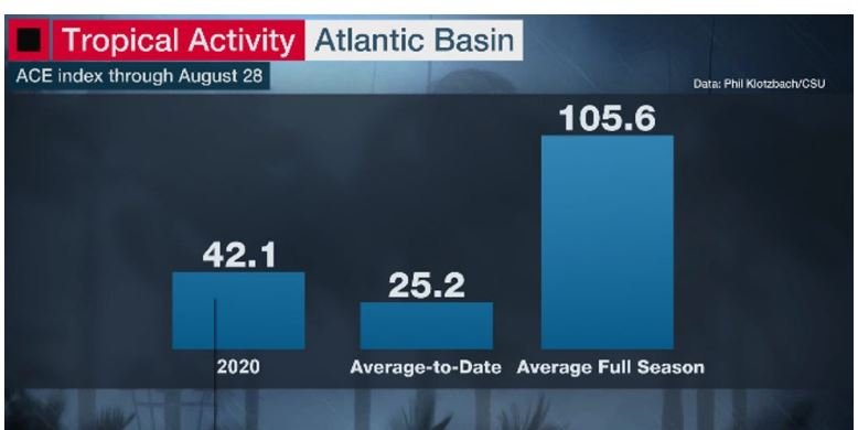
Currently 2020 is the 9th most active season through the end of August in the satellite era when using ACE index with the number at about 42 so far. With "peak" still a week away and initial ACE forecasts of 130 to 160 there's still a lot of time for some big things to happen if those forecasts pan out. One thing I'm thinking about is we are just now entering "major hurricane season". The higher percentage of majors occur from now moving forward. Sure it's not been exciting from a "headlines" standpoint so far but as others have said we're just now heading into the active period that statistically has the highest threat of stronger storms. Now if we do get 3 or 4 more majors with an ACE of 150 for the season this year along with weaker storms and the majors all are fish,will folks still be saying this season's a bust? Probably lol...... Cat 3 by month Cat 4 by month Cat 5 by month
-
SAL/dry air has shut down anything currently coming across/off Africa but there's 3 fairly stout waves following this last episode of very dry air. It's a wait and see if any can make a run into the Atlantic towards the end of the week. Also, link to a sat view of a pretty strong dust storm over the west central Sahara I thought was cool http://tropic.ssec.wisc.edu/real-time/sal/msg_rgbdust/movies/msg_rgbdust.html
-
If anything develops I think a lot is going to depend on the evolution of that monster SW conus ridge. GEFS and EPS along with the OP's show it breaking down to varying degrees around day 7 in general. There are trends toward zonal flow across the northern conus after that for a few days farther out into fantasy land across the board. A setup like that, IF it were to happen can sometimes lead to headaches forecasting a track for anything in the SE Bahamas, S GOM or the W Caribbean. Weaker steering and/or something getting trapped under a conus ridge-WAR battle. Stalls, left turns and loops oh my.
-
This. My biggest concern is exactly that. There's been consistent modeling of relaxed shear in the Caribbean for some time now, especially the eastern Caribbean. While normally the eastern Caribbean shear tends to relax during the peak it doesn't usually do it for very long, there always seems to be a retrograding TUTT that throws a fly in the ointment for any long track storm that gets in there and tries to traverse south of Cuba. Most years that shear tends to keep anything traversing the eastern Caribbean at least in check if not ripping it apart. Of course some have made it through if the timing's right but the eastern Caribbean is usually a tough place for any storm. The consistent modeling of a relaxing of that shear for an extended period of time increases the chances for a southern long tracker to sustain intensity right into the GOM. May not happen at all but I think there's increasing chances of that possibility.
-
It's not real
-
An average season of 10-12 has 2-3 named storms by now with 75% occurring over the next 6-8 weeks. This anomalous beginning is accounting for almost half of the very active season being forecasted. Since we already have 9, even and average Aug - Oct would put us upwards of 20. So it doesn't necessarily mean the tropics have to "blow up" soon in order to meet the current forecast. A moderate above average Aug - Oct, say 10-12, as opposed to the Aug - Oct 8-10 average could hit the threshold of some of the forecasts. I think that's an important perspective. We've almost got a 3rd of a high end 25 storm forecast in the bank by the first week of August. Even an average or slightly below average Aug- Oct portion will still put the entire season as well above average. So the question is, has the anomalous above average season being forecasted already occured? Edit: Just trying to point out that moving forward could be an average season in the timeframe left. Some people may be disappointed if storm after storm doesn't start cranking soon and think the forecasts are off. I'm putting odds on a normal, maybe slightly above normal Aug - Oct storm count.
-
And OMG people may be socking it away because they don't know what's around the corner. Paying off debt to reduce or eliminate bills in case it gets worse. God forbid Americans cut their credit cards, increase their savings and stop borrowing money for things like snowmobiles. When this first hit banks were getting jumpy because people were suddenly paying down credit card debt, were trying to increase their savings. When I was a kid that was taught to me as being financially responsible. This economy is a slave to debt. I choose not to participate in that type of economy thank you very much.



