

weatherwiz
-
Posts
79,817 -
Joined
-
Last visited
Content Type
Profiles
Blogs
Forums
American Weather
Media Demo
Store
Gallery
Everything posted by weatherwiz
-
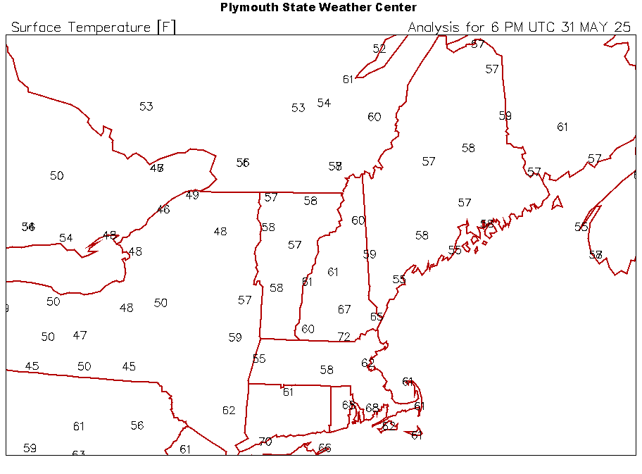
These "big swing" days suck. 40 to 75...BOOOOOOOOOOOOOOO. We need those high dews where the day begins at 73-75 and there is so much dew that you wake up in sweat. Save this for the desert.
-
So is it worth staying up for?
-
There are going to be several different influences on the positioning and speed of the front. Going to be a tremendous deal of convection (well already has been) between what’s been ongoing and the end of the week.
-
Yeah not a crazy setup for widespread severe but we would certainly see some localized severe weather each day I'd think.
-
Agreed with this, great add.
-
One thing to note as well for the Thursday - Saturday period is this is going to be much more convective so that opens up the door for some significant rainfall totals (at least locally)...models could certainly end up underdoing the extent of totals. Also, some areas will get significantly rainfall than forecast. Where the front becomes held up could be critical because there could be some major flood concerns up north.
-
I guess it's kind of a get out to a dark spot and hope situation lol. From what I can gather reading around, its waning but there may be instances of pulsed activity.
-
This still looking hot tonight?
-
It’s a good thing this is just a steady rain and not a steady torrential rain
-
Rain won’t stop
-
At Costco in Enfield and hoping this moves out but it seems like the back edge keeps back building
-
Someone laughed
-
Crazy rain overnight but have sun now!!! Wasn’t fully expecting that, at least this early
-
what the heck kind of a name is that?
-
Looking back at this, I'm not sure there was ever much support for such a feature really and not sure it synoptically made sense.
-
Second half of the week is shaping up to be on the hot/humid side. The signal for that cut-off low is fading and we are going to turn the flow WSW or SW with the front approaching and eventually stalling somewhere within the region. Going to be lots of mid-to-upper 80's to lower 90's in the torch spots if we mix fully.
-
yikes...looks like a brown recluse or some cousin of it
-
WTH
-
Couldn’t even happen in Dante’s Peak…barely but not really
-
little TDS just southeast of Atlanta
-
that cell in SW CT produced an F1 too! nice looking velocity scan
-
I remember that day! I was at my sisters house and they were talking about it on the news with the active warning
-
I use May 1st (for no other reason except why not) but its usually mid-June through mid-July where are best window lies. But we can get some nasty stuff in august, particularly on the nocturnal side
-
Yup...all about expectations really. I would have to wager that for much of the region (for those prone to 90's), most of them on average come from like late July into the 2nd week of august.
-
It's also only May 29 lol...I mean I know we've had some year previous where we've had multi-day stretches of 80's with spots already having at least one 90+ day but I mean come on


