weatherwiz
-
Posts
79,812 -
Joined
-
Last visited
Content Type
Profiles
Blogs
Forums
American Weather
Media Demo
Store
Gallery
Everything posted by weatherwiz
-

December 2025 regional war/obs/disco thread
weatherwiz replied to Torch Tiger's topic in New England
Explains why your forecasts have gone downhill -
December 2025 regional war/obs/disco thread
weatherwiz replied to Torch Tiger's topic in New England
The real problem I think would be if the strong blocking persists. We would probably get chances as the block is materializing and then we'd want to hope for the block to relax or break down a bit and that could come with some chances. But if a big block materializes and becomes established...then we may be screwed -
December 2025 regional war/obs/disco thread
weatherwiz replied to Torch Tiger's topic in New England
I love the euro op phasing of a TPV piece with southern stream energy across the Carolinas towards the end of the run lol -
December 2025 regional war/obs/disco thread
weatherwiz replied to Torch Tiger's topic in New England
yeah soundings are quite inverted there. Looked like though there could be room for a line with thunder/lightning. Probably the only way to draw down any good gusts. -
December 2025 regional war/obs/disco thread
weatherwiz replied to Torch Tiger's topic in New England
some violence for the Cape on the 6z HRRR -
December 2025 regional war/obs/disco thread
weatherwiz replied to Torch Tiger's topic in New England
I wonder if we could see some snow squalls into western areas late Friday afternoon -
December 2025 regional war/obs/disco thread
weatherwiz replied to Torch Tiger's topic in New England
yeah and they seem to target coastal VA/NC. Should be getting a new D3 update though within the next 5-15 minutes. -
December 2025 regional war/obs/disco thread
weatherwiz replied to Torch Tiger's topic in New England
If the fun weather can't come to you, you go to it. I don't think I've ever seen a civil emergency message for wind before. Sure its happened but must be rare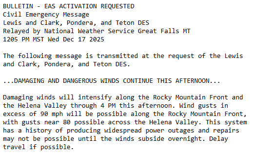
-
December 2025 regional war/obs/disco thread
weatherwiz replied to Torch Tiger's topic in New England
NAM/GFS do have an insane LLJ at 925 materialize across eastern CT/RI/E MA through Friday morning...so something to definitely keep an eye on if that can be tapped into. This does happen to coincide with the leading edge of the main rain area too, however, there is a stout inversion too -
December 2025 regional war/obs/disco thread
weatherwiz replied to Torch Tiger's topic in New England
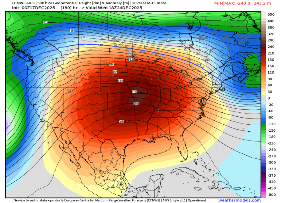
I wouldn't be shocked if that ridging in the south is too smoothed out too. I would wager probably more of a ridge axis into the upper Mississippi Valley which could then argue for some lower heights in the Northeast The overall structure of that trough across western Canada's coast will be a big player too -
December 2025 regional war/obs/disco thread
weatherwiz replied to Torch Tiger's topic in New England
The stratosphere is certainly going to try and help get us a favorable Arctic domain.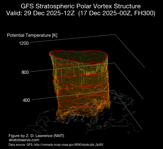
-
December 2025 regional war/obs/disco thread
weatherwiz replied to Torch Tiger's topic in New England
I hope its 85F on April 17 so I can watch playoff hockey outside with just a jersey on -
December 2025 regional war/obs/disco thread
weatherwiz replied to Torch Tiger's topic in New England
My recommendation for those people then would be to move to the Sierra's or Cascades lol. I mean if we're active with 3-4" events and people are still complaining then something is wrong. Surely we all want the big storm but there has to be some sort of realistic expectation too. -
December 2025 regional war/obs/disco thread
weatherwiz replied to Torch Tiger's topic in New England
I could see a marginal get thrown up for far eastern CT/RI/SE MA. the NAM would certainly argue it but sometimes the NAM gets a little overzealous with elevated in stability in these setups. NAM does have a pocket of steeper mid-level lapse rates (and greater CAPE) but I think its overdone in that regard. The key for eastern areas will be little to no shower activity ahead of the main area -
December 2025 regional war/obs/disco thread
weatherwiz replied to Torch Tiger's topic in New England
Yeah I agree, I definitely would like to start getting some bigger systems, but if we can pull off a good two week stretch where we get 3-4 systems in the 2-4" range...I would hope that makes everyone a bit happier lol. -
December 2025 regional war/obs/disco thread
weatherwiz replied to Torch Tiger's topic in New England
The 27-29 period looks like it could be interesting -
December 2025 regional war/obs/disco thread
weatherwiz replied to Torch Tiger's topic in New England
Well this isn't fair. Damn you Idaho
-
December 2025 regional war/obs/disco thread
weatherwiz replied to Torch Tiger's topic in New England
when you're in the Cascades -
December 2025 regional war/obs/disco thread
weatherwiz replied to Torch Tiger's topic in New England
The NBM does really well with sky cover forecasts I think. Out of MOS/NBM, the NBM was the only guidance bringing in these clouds through the day today followed by some clearing late afternoon/evening then increasing late. -
December 2025 regional war/obs/disco thread
weatherwiz replied to Torch Tiger's topic in New England
I have these thoughts too. I've been creating composites of SSTs focusing on the Pacific for EL Nino/La Nina dating back to 1900 with a focus on the WPWP. There's lots of studies out there discussing how it has expanded over the last 2-3 decades along with the extension of the WHWP. But even with the Nina look...those 29-30C temps are extending well east, just past the dateline. Definitely sufficient to sustain strong convection around the dateline which I believe is something that enhances ridging across the NPAC?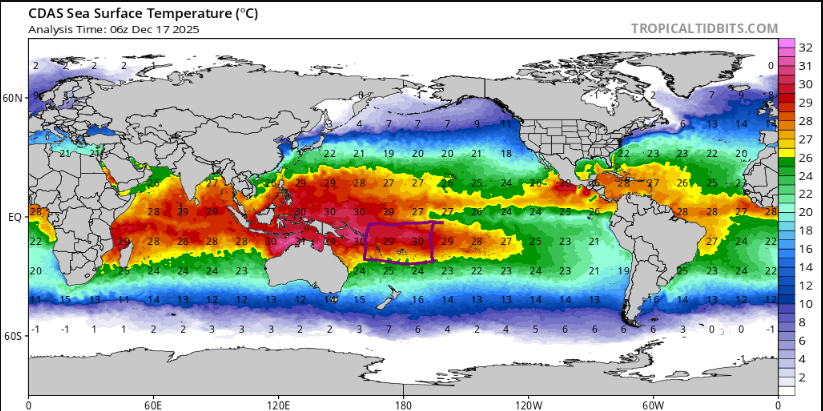
-
December 2025 regional war/obs/disco thread
weatherwiz replied to Torch Tiger's topic in New England
Do you have any blog posts which have explored the snowless periods of previous decades? I am really curious how this stretch compares/contrasts to those periods. I've always been under the impression those periods were the product of colder/drier winters (or moreso drier) while as this stretch we are still pulling off subpar seasons even when we're cold/wet. I mean who cares if we've gone through this before in the 1980's if its for completely different reasons. -
December 2025 regional war/obs/disco thread
weatherwiz replied to Torch Tiger's topic in New England
Despite the -PDO having leveled off, I think its still severely screwing us with shifting the East Asian jet north. -
December 2025 regional war/obs/disco thread
weatherwiz replied to Torch Tiger's topic in New England
I legit am nervous. I know its early, but in the grand scheme of things, we're already assessing how the pattern looks to evolve post Christmas into New Years. If that period ends up sucking then we'll be looking towards mid-January...and so forth. I truly believe we need to completely flush out the entire atmosphere...we probably need a good multi year stretch where ENSO is a non factor and then hope we are truly on the -PDO decline. At some point the odds have to return to our favor but the background state is far from it, IMO. -
December 2025 regional war/obs/disco thread
weatherwiz replied to Torch Tiger's topic in New England
Don't get him going -
December 2025 regional war/obs/disco thread
weatherwiz replied to Torch Tiger's topic in New England
Wouldn't mind getting this pattern in July. Monopoly Weather Chance Card: Take a ridge on the derecho express