weatherwiz
-
Posts
79,812 -
Joined
-
Last visited
Content Type
Profiles
Blogs
Forums
American Weather
Media Demo
Store
Gallery
Everything posted by weatherwiz
-

White Christmas Miracle? December 23-24th
weatherwiz replied to Baroclinic Zone's topic in New England
This didn't happened when I was in school (although maybe it was being discussed when I was in high school and implemented shortly after) but do they use days from like February or April break to make up for snow days instead of going deeper into June? I know some districts had done this. -
White Christmas Miracle? December 23-24th
weatherwiz replied to Baroclinic Zone's topic in New England
If roads are going to be messy, there really is no need in making people go out and travel, especially now with remote learning an option and remote work (obviously there are exceptions) but its disheartening when you hear and read of accidents because of weather and people are killed. No need to have busses out in these road conditions -
White Christmas Miracle? December 23-24th
weatherwiz replied to Baroclinic Zone's topic in New England
100% agreed. It's extremely underrated. I remember when it first came out I didn't recall wanting to see it because it had none of the original cast but I remember watching it when I was sick...it was hysterical. -
White Christmas Miracle? December 23-24th
weatherwiz replied to Baroclinic Zone's topic in New England
parts of BGM CWA upgraded to a WSW. Been under a nice band there -
White Christmas Miracle? December 23-24th
weatherwiz replied to Baroclinic Zone's topic in New England
That reminds me of Home Alone 3 when the burglars blocked off a road and cut down the street sign and replaced a mailbox to make the road entrance seem like a driveway -
White Christmas Miracle? December 23-24th
weatherwiz replied to Baroclinic Zone's topic in New England
Went outside earlier and enjoyed the quietness with just the crackling sounds of the wet snow hitting the ground. Peaceful and relaxing, good for the soul and mental health. -
White Christmas Miracle? December 23-24th
weatherwiz replied to Baroclinic Zone's topic in New England
Not surprising where the swath of accumulations have been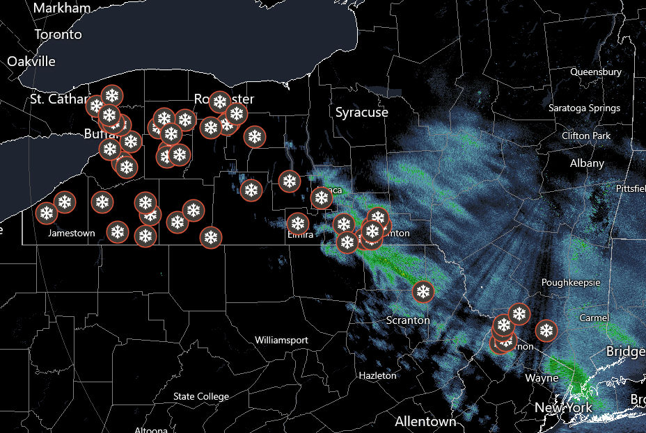
-
White Christmas Miracle? December 23-24th
weatherwiz replied to Baroclinic Zone's topic in New England
All the hooplah about the snow and hardly any posts nor an obs thread lol -
White Christmas Miracle? December 23-24th
weatherwiz replied to Baroclinic Zone's topic in New England
Very light snow falling, ground coated! -
White Christmas Miracle? December 23-24th
weatherwiz replied to Baroclinic Zone's topic in New England
Hoping for 1.5” tomorrow and that will get me to about 7” for the season and only 93” away from 100”!!! -
White Christmas Miracle? December 23-24th
weatherwiz replied to Baroclinic Zone's topic in New England
Shoreline probably still cooked but this is still looking like a solid 1-2" for most and the lucky ones will grab 3...maybe even 4" for those super lucky. -
White Christmas Miracle? December 23-24th
weatherwiz replied to Baroclinic Zone's topic in New England
I think it also has to do with the timing plus the increased holiday travel...just a way to increase awareness -
December 2025 regional war/obs/disco thread
weatherwiz replied to Torch Tiger's topic in New England
Add "Atmospheric River" to the list of overused and ridiculous weather terms. -
White Christmas Miracle? December 23-24th
weatherwiz replied to Baroclinic Zone's topic in New England
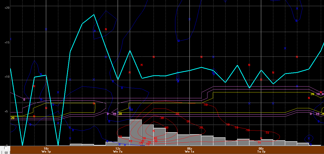
PWM crushed on GFS for sure. Bufkit is pretty impressive there. If that inv trough does take shape and evolve as hinted, someone is going to get crushed. This argues for a foot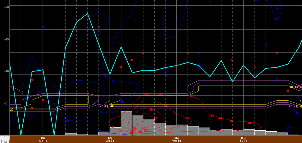
-
White Christmas Miracle? December 23-24th
weatherwiz replied to Baroclinic Zone's topic in New England
Yup...becoming pretty clear they may cash in pretty well from this. Also encouraging seeing the GFS remaining more juiced for all, but seeing the mesos, I wonder if there is some resolution influence going on and the GFS isn't going to fully depict a similar look like some of the mesos are showing. Regardless, definitely feeling most should pick up 1-2" (coast may be burned though with marginal BL temps). Will be some surprises (Berk/NW Hills) that get 3-4". -
White Christmas Miracle? December 23-24th
weatherwiz replied to Baroclinic Zone's topic in New England
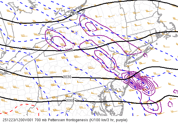
That's a pretty good hit from SW ME into S NH on the GFS...easily warning criteria there -
White Christmas Miracle? December 23-24th
weatherwiz replied to Baroclinic Zone's topic in New England
Looks very reasonable. I have yet to look in depth yet (haven't even checked out bufkit) but one killer here is ratios aren't going to be great (except far interior) and lift overall probably not terribly great across the region as a whole...but all of this is rather insignificant anyways given we aren't dealing with a high ceiling anyways. -
White Christmas Miracle? December 23-24th
weatherwiz replied to Baroclinic Zone's topic in New England
Yeah if I was making a snowfall forecast now I would go in the 1-3" range for a large area...maybe something along the lines of 3-4" for the Berks and maybe far northwest CT. -
White Christmas Miracle? December 23-24th
weatherwiz replied to Baroclinic Zone's topic in New England
They aren't, their evolution is entirely realistic. This one is most likely going to be more of a nowcast May put together a forecast later this afternoon or early this evening. -
White Christmas Miracle? December 23-24th
weatherwiz replied to Baroclinic Zone's topic in New England
Seems like the GFS is at least a bit more impressive with the WAA. Not sure what to make out of the NAMs but I am a little concerned with them because the solutions aren't farfetched. -
December 2025 regional war/obs/disco thread
weatherwiz replied to Torch Tiger's topic in New England
Those retrograding blocks can really work in our favor and models can struggle with those. That's when you can see one run showing a 980 low tracking north of the Great Lakes and then two runs later is tracking 700 miles south lol. All in all...that trend is not bad looking. I also wonder what role that cutoff southwest of Baja would play...sometimes that can be beneficial to us and sometimes not. But it does seem to be assisting in those higher heights into the PAC NW. Still some room here but its encouraging to see at this stage -
December 2025 regional war/obs/disco thread
weatherwiz replied to Torch Tiger's topic in New England
The trends have certainly been noteworthy, you've done a damn good job and highlighting these trends (and not just with this period) over the past few weeks. It's been great to see some trends moving in our favor as we get closer to an event versus the other way around, which has plagued us the last several winters. I am very intrigued moving into and through January. -
White Christmas Miracle? December 23-24th
weatherwiz replied to Baroclinic Zone's topic in New England
Going to be a weird one tomorrow...probably going to see some surprises on both sides of the spectrum...overperforming somewhere locally and underperforming somewhere too. Should rip decently though for a time wherever that fronto band traverses -
December 2025 regional war/obs/disco thread
weatherwiz replied to Torch Tiger's topic in New England
Still great to see this upcoming period continuing to hold potential. The late weekend period has my eye -
December 2025 regional war/obs/disco thread
weatherwiz replied to Torch Tiger's topic in New England
You’re right it’s not cold, it’s nice out. So many people out jogging, walking the dog, kids playing in the park, people sitting outside enjoying the sun in their lawn chairs, smells of BBQ’s going with people playing corn hole, have some people hiking along trails. It’s not cold