

weatherwiz
-
Posts
71,352 -
Joined
-
Last visited
Content Type
Profiles
Blogs
Forums
American Weather
Media Demo
Store
Gallery
Posts posted by weatherwiz
-
-
8 minutes ago, Dan76 said:
Was in the 90's there today.
they did get into the 90's? wow...must have shot up quick.
-
1 minute ago, Dan76 said:
Philly forum says berks co a mess
I bet...winds of like 70-80 were more widespread than isolated I think. Don't see that often (around here).
Just now, dryslot said:All kidding aside, Pretty impressive i will say on goes 16.
I wonder what would have happened with a few more hours of heating but that area was prime for big wind. Right on the edge of an EML, super steep llvl lapse rates, great rear inflow. Why can't we do this

-
Man...that could be VERY close to confirmed derecho criteria.
-
 1
1
-
-
4 minutes ago, Dan76 said:
Reading airport gusted to 83 mph...that's nuts
-
That squall line that went through SE PA and NJ meant BUSINESS. That's a top notch squall line for these parts.
-
3 minutes ago, Chrisrotary12 said:
Enhanced Risk this morning. Impressive morning squall line racing ESE. Could be offshore before noon.
If this was timed several hours later could have been a huge event across PA into NJ...probably moderate risk type.
-
15 hours ago, Dr. Dews said:
Euro has a nice svr setup D9 with Cristobal remnants. Lock it
I'm not a big fan of severe set ups associated with tropical remnants...usually have piss poor lapse rates...and I mean piss poor and there's usually some sort of capping in place. Shear usually good though! But the thermodynamic environment (outside of SBCAPE) is pfttttttttttttttttttt
-
Sweet...I'm glad to finally see a slight risk into PA for today
-
 1
1
-
-
3 minutes ago, Ginx snewx said:
We have had some pretty good scattered severe in Ct the last couple of years. Hamden tornado etc. Pretty much our climo.
2018 was wild...especially the tornado events we got in September. Severe climo across the country in general though has been a bit off the past several years...hell, this past May I think was historically low in terms of tornadoes.
Just now, ORH_wxman said:The glory days are gone:
I still remember that day like it was yesterday. The period between 05/29/1998 - 06/02/1998 I bet would be the most active 5-day period of severe in the Northeast on record.
-
5 minutes ago, dendrite said:
Representative image of daytime severe season in New England:
I can't even see that
3 minutes ago, MaineJayhawk said:We're almost at July?
In the model world...yes
-
I think we should just cancel severe season...what a freaking joke. Unless we get an active second half of summer but how often does that happen? The majority of our bigger events happen from like mid-to-late May into early July and we're almost at July. The only fun thing about the second half of summer is we can get some nasty nocturnal events but those kinda suck b/c you can't see cloud features. BUST

-
1 minute ago, weathafella said:
The one you were serving dogs in the basement for?

-
Just now, Ginx snewx said:
No way it was a 3 yet Great Barrington a 4
I agree...I'm shocked it wasn't rated an EF-4. I mean it was really only 10-mph off that classification. But those damage pics were ridiculous. Hell...it was more of a 4 I think than the Hamden, CT one was. I guess questions about building codes?
-
Can't believe it's been 9-years since the EF-3 tornado

-
1
-
-
That is some pretty impressive elevated CAPE to our southwest tomorrow night. I am shocked there isn't a Slight across PA...hell I could even argue for an enhanced...could be some pretty big hailers tomorrow night. Perhaps limiting factor is dewpoints but this is a sounding from NE PA...pretty ripe atmosphere for big hailers

-
Just now, Ginx snewx said:
I spend the majority of my time outdoors?
must be the pollen then
-
 1
1
-
-
1 minute ago, Ginx snewx said:
Let's hope we see crisp clean Canadian air masses dominate nobody likes the stinky rank high dew foggy wet air being outside. Well check that, those who thrive in AC might
I think the stuffiness of being inside has gotten to you
-
Still watching severe wx/EML potential perhaps after weekend...some hints the pattern could favor this but who the hell really trusts these medium range looks
-
This is going to be a bit hard to do with dewpoints only in the 30's though...so perhaps isolated is the better way to go over scattered. ughhhh only if dewpoints were like in the 50's. We would probably see golf ball hail potential
-
6 minutes ago, CoastalWx said:
Maybe good mixing and limited canopy helping the heat?
Here's the 18z HRRR for BTV...mixing up to nearly 750!

-
2 minutes ago, RUNNAWAYICEBERG said:
Don’t get SEMA hopes up. They’ve been let down all too often with faux severe threats.
That's b/c they get excited for setups which favor NY/PA into western New England lol.
-
21 minutes ago, wx2fish said:
Sat could be a sneaky downslope dandy if the front clears in the morning. Euro has lingering 850s around 10-12C and west flow
Also can't rule out potential for a strong/severe storm across SE New England...especially along any sea-breeze.
-
Scheduling a launch for a late spring afternoon during prime t'storm time and into prime t'storm season...
-
1
-
 1
1
-
-
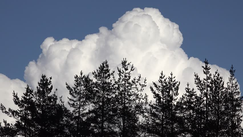
I absolutely love the thunderstorms in the distance...the view of towering TCU's in the sky make me tingle all over. Only thing better is when they're over you.
June Discussion
in New England
Posted
I do!
Woke up 6:00 AM and wasn't feeling well so went out to the living room to turn on The Weather Channel. After sitting there for like a half hour and no weather I asked my mom what's going on...turned out the TV lineup changed that day. We finally found the station...turned it on....BOOOOOOOOOOOOMMMMMMMMMMMMMMMMMMMMMM major squall line ripping through NY and heading into MA.