

weatherwiz
-
Posts
71,434 -
Joined
-
Last visited
Content Type
Profiles
Blogs
Forums
American Weather
Media Demo
Store
Gallery
Posts posted by weatherwiz
-
-
8 minutes ago, dryslot said:
SHARK!!

Baby shark do do do do do do
-
 2
2
-
-
Lots to resolve of course but can't sleep on Saturday...Sunday may not be much (it's either going to be Saturday or Sunday) but Saturday is sneaky...could actually see a window for a few supercells
-
 1
1
-
 1
1
-
-
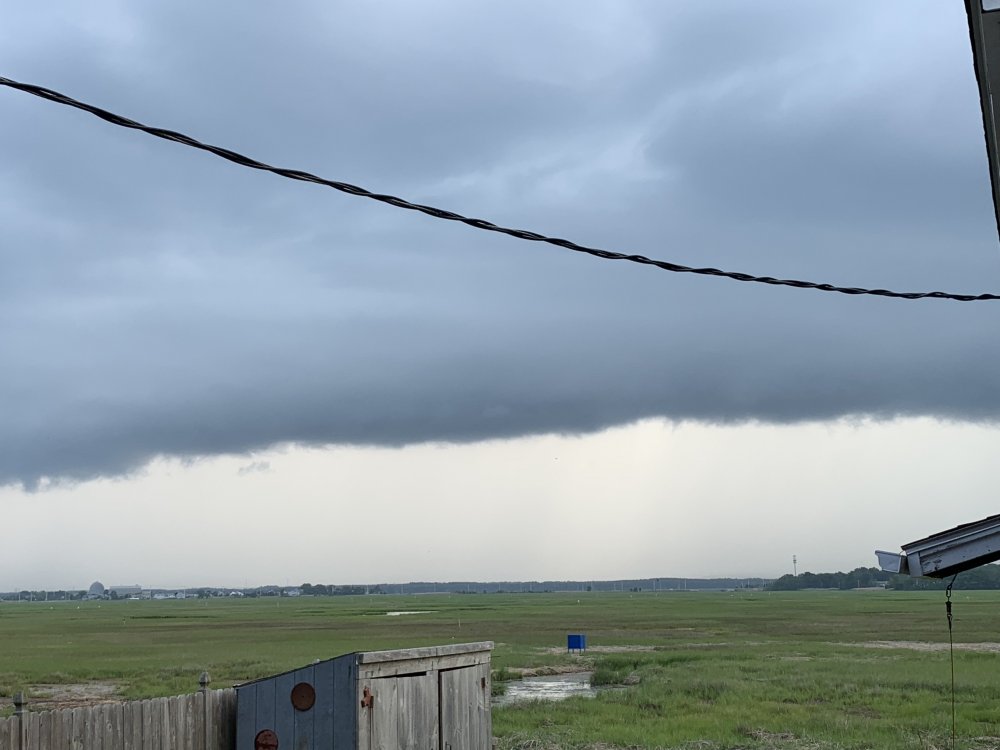
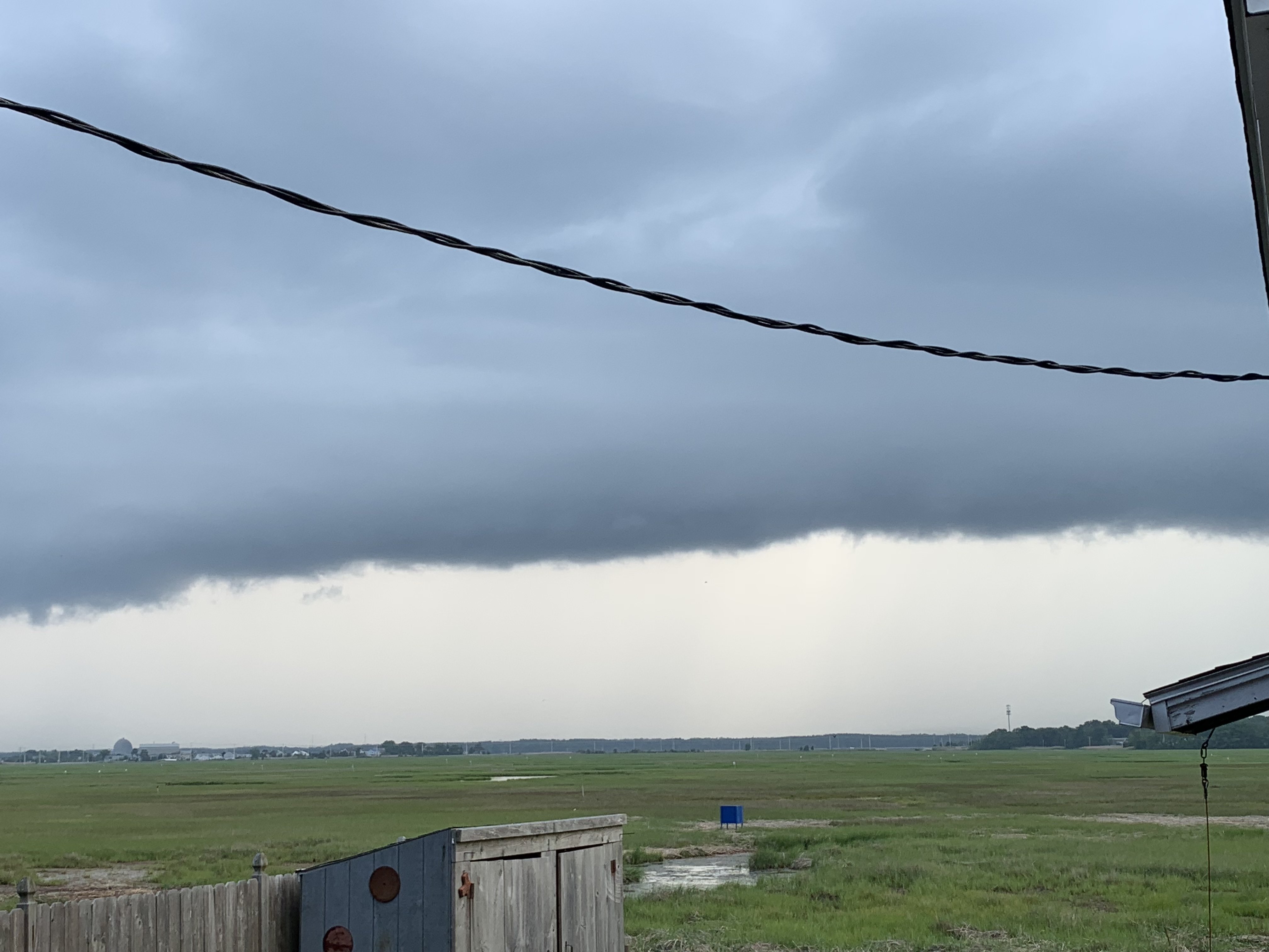
25 minutes ago, KoalaBeer said:
Decent looking shelf cloud looking west off my back porch in Hampton.
I am staying in Hampton next Wednesday - Saturday. About 2 miles from Hampton Beach. Kinda wish we actually booked a bit closer but oh well. Do you know of any fireworks going in in NH during this window? Looks like the ones on the beach are a no-go b/c of the endangered birdies
-
55 minutes ago, STILL N OF PIKE said:
So where is best shot of sunshine this weekend
the side of the Earth facing the sun
-
1
-
2
-
-
At least they'll get plenty of severe chances in the northern Plains with that look...perhaps upper-Midwest too
-
Finally...I'm getting tingles as my fingers stroke the keyboard typing this up. Intense tingles...just like the intense updrafts that will be plowing through the troposphere this weekend headed towards the stratosphere before the EL smacks them short.
Low pressure associated with a fairly strong shortwave progresses slowly through southeast Canada over the weekend. As this strengthens we see an increase in winds aloft with 500mb winds in excess of 30-50 knots. At the surface a warm and humid airmass with sfc temperatures at least into the 80's with dewpoints into the 60's. Steeper mid-level lapse rates associated with the energy will help to contribute to MLCAPE values approaching 1500 J/KG both days...perhaps near 2,000 depending on degree of sfc heating.
Given sufficient wind shear aloft, the main severe threat will be damaging winds, however, an early look at forecast soundings indicate straight and long hodographs. This would suggest splitting cells with an accompanied risk for large hail.
Saturday looks to feature numerous t'storms from NY into northern New England...with the potential for the evolution of an MCS which could come with the threat for widespread damaging winds. Activity should persist into at least western sections of New England before beginning to diminish, however, activity may push through much of the region. The damaging wind threat could extend into MA should an MCS evolve (MA and southern NH).
Sunday is a wildcard as it will all be dependent on cloud debris, however, strong shear and potential for sufficient CAPE will be there.
FINALLY SOMETHING TO TRACK!!!!
-
9
-
-
Just now, Damage In Tolland said:
Saturday is hot and muggy and sunny. Sunday is more for CNE/ NNE. Might be hit or miss stuff SNE, but the line looks north
Saturday could see something actually make it through much of the region. Sunday is a big wildcard though...but the potential is there. Alot will depend on previous day convection/cloud debris. Saturday could actually see a pretty solid MCS develop up north with maybe widespread wind damage.
-
22 minutes ago, Damage In Tolland said:
Everything forming East again. Record for consecutive days at BDL of no measurable in May- September is 18 days. Today is #13. Sunday’s the only chance and even then, not high. Let’s root to break it. 19 is record for most days any month. All courtesy of Gibbs.
I'm actually starting to think there will be widespread t'storms Saturday and Sunday...though Saturday may be a bit more west I think activity will push into western sections before diminishing. Sunday could be a decent severe day given we have sufficient instability. Could see splitting storms with wind damage/large hail.
Making a thread after!!!!!!!!!!
-
2
-
-
Thanks for the input all. Actually I didn't even think about a sleep therapist. Going to find a really good primary care doctor and just get myself towards being healthier and feeling better.
Anyways sorry for completely derailing but let's hope Sunday pan out...severe or not could actually see showers and t'storms be more widespread
-
4 minutes ago, Great Snow 1717 said:
Most doctors would not recommend using Motrim PM as a sleep aid if you are not experiencing pain. As with many drugs a "addiction" can develop. Someone can develop a "need" for it....in other words feeling a need for it in order to sleep. And a tolerance to the drug can build over time. Speak to your primary care doctor. Another thing for you to consider is consulting with a sleep specialist .
Do you drink caffeinated beverages?
I don't really. I hardly drink soda anymore and actually since I've been working from home I've cut back on coffee too. I used to have one a day (like 6 AM) but that would be it. I used to have issues falling asleep but now that I wake up super early I tend to fall asleep pretty quick but I just wake up every few hours. I would estimate I maybe get like 4 hours of sleep per night in total.
I don't mind taking something that isn't going to led to big side effects...It probably wouldn't be something I take every night either. I want to steer away from actual sleep pills though b/c I've heard nothing but horrific things from them. My grandmother was prescribed some and she used to have vivid and horrific nightmares each night...legit thinking they were real and it would take quite some time to calm down
Just now, Ginx snewx said:No not at all.
that's good!
-
THERE MIGHT BE A SMALL WINDOW FOR A SEVERE THREAT SUNDAY!!!!! SMALL...TINY...BUT IT'S SOMETHING!!! WOOOOHOOOOOO
-
1
-
4
-
-
Just now, Ginx snewx said:
Motrin PM
is that addictive or have bad side effects?
-
1
-
-
12 minutes ago, Ginx snewx said:
Lol, 10ish for me. Up at 5 like clockwork. Great to see cocadoodledewless back in the picture
I try to go to bed like 8-9 but I'm a horrific sleeper. Wake up numerous times throughout the night and I always feel terribly tired when I wake up...hardly ever feel refreshed. It's the most annoying thing ever. Early afternoon comes and I'm dead.
-
1 minute ago, ORH_wxman said:
Time to move west into Litchfield county and embrace winter. You will get more severe there too.
NW CT is like an entirely different climate. Norfolk area would be perfect...there are some houses which have amazing views to the west and they get nailed with snow in the winter.
-
Just now, ORH_wxman said:
I'm sure we'll get pulsers that collapse on themselves after 30 minutes.
That's all that's been happening. It's been pure garbage. Winter just can't come fast enough at this rate. This is just plain stupid.
-
we better at least see this pattern evolve to produce several derechos across New England for July and August.
-
1
-
 1
1
-
2
-
-
4 minutes ago, klw said:
This AFD seems to speak your language even if it leaves you wanting
There are some modest changes in the synoptic environment today.
The 850mb ridge axis has pushed ewd toward coastal New England
as a slow moving mid-level trough translates ewd across the
Great Lakes region. This allows for modest mid-level height
falls across our region this afternoon, along with weakly
cyclonic flow aloft. Also noting that sfc-6km bulk shear
increases to 15-20kts. While not a dramatic increase, there is
some better potential for multicellular convective storms rather
than strictly short-lived "pulse" storms that have characterized
the past couple of days. Storms should still initiate along
higher terrain areas with minimal low-level convergence, but
will have a better potential to move away from the higher
terrain with ENE storm motions around 10 mph. Have shown PoPs
30-50% this afternoon into early this evening, highest across
the Adirondacks and near the spine of the Green Mtns. Hot PBL
temps combined with dewpoints in the mid 60s should yield SBCAPE
values of 1000-2000 J/kg. Given moderate CAPE, somewhat better
shear, and better expected storm coverage, continued to include
gusty winds, small hail, and heavy rainfall wording with any
storms this afternoon into early this evening. Should also see a
bit stronger surface winds today...generally S-SW at 10-15 mph,
with a few gusts up to 20-25 mph in the Champlain Valley.
could def see some small hail along with strong wind gusts with the stronger storms
-
1 minute ago, weathafella said:
Gfs sucks for mid next week...
more ulvl low cutoff crap. I'm getting so pissed off with this ****. Can't get severe setups with that garbage hanging around. The atmosphere is such a trolling POS tease.
-
Just now, STILL N OF PIKE said:
I am interested to see how much rain some places can squeeze out Wednesday if things train
areas that get hit will probably get nailed pretty good...it will probably just be rather localized. But I could see 1-2'' of rain in the hardest hit spots. Forcing along/ahead of the front doesn't seem particularly strong and actually looks like there is quite a bit of dry air in the mid-levels.
-
Just now, STILL N OF PIKE said:
HFD doesn’t get blasted by Ocean effect ?
nope...downslope from Mount Tolland screws us
-
1
-
-
28 minutes ago, STILL N OF PIKE said:
Fixating on SNE severe is like jimmy waiting for the big ocean effect to show up on models
Not happening Wiz
severe is much more common here than big ocean effect snows
-
5 minutes ago, Damage In Tolland said:
SNE looks very hit or miss. Can’t even generate a line .
We get nada
-
9 minutes ago, HoarfrostHubb said:
Legit severe or SNE version of “severe”?
SNE version of svr...perhaps some localized damaging wind gusts and pea sized hail...maybe even see a 1'' hail report.
-
1
-
-
could maybe see a few severe t'storms across eastern MA, NH, and parts of ME tomorrow.
Saturday, June 27 - Sunday, June 28, 2020 Convective Thread
in New England
Posted
This is starting to become a bit more clear.
While I still think a good chunk of the region sees something late Saturday the severe threat should wane pretty quickly across western sections...though this could extend through central CT. Sunday looks more like eastern areas.