

weatherwiz
-
Posts
76,468 -
Joined
-
Last visited
Content Type
Profiles
Blogs
Forums
American Weather
Media Demo
Store
Gallery
Posts posted by weatherwiz
-
-
-
2 hours ago, OceanStWx said:
Well you kind of did on 6/1/11

I was selling hot dogs

-
Thunder in Springfield!!!
-
I can't get over 500 m2/s2 of effective helicity juxtaposed with >1500 J/KG of MLCAPE and >100 J of 3km CAPE...it just seems unreal
-
 1
1
-
-
14 minutes ago, HoarfrostHubb said:
Just awful. Forecast called for chances of Tor. Did they get the area correct?
Yes.
The event and it's potential were very well forecast!
-
5
-
-
15 minutes ago, CoastalWx said:
Is that official? I just saw the possibility.
I think it's just a question of whether it was on the ground from it's initial warning point of near Jonesboro...may have to fully wait for survey but if it was then it will likely be official. Still can't believe this...so tragic
-
1
-
-
no signs of slowing down
-
1
-
-
-
3 minutes ago, FXWX said:
I doubt it... Hopefully the warnings were so good, which they were that folks got into sturdy shelters; although given the likelihood this was an EF 3 or 4, not sure they could have completely escaped without numerous injuries???
Probably would be a miracle. NROT values exceeding 2

-
1 minute ago, Ginx snewx said:

Remarkable...really hope everyone is alright
-
Just now, FXWX said:
Incredible TDS's this evening! Horrible situation.
Really terrible and it's not going tp improve any over the next several hours.
-
That is a large TDS over Mayfied....holy crap
-
My God...500 m2/s2 effective helicity across western TN to go along w/greater than 100 J 0-3km CAPE and 2000 J/MLCape. That stuff is going to explode in western TN
-
1 minute ago, Hoth said:
That cell in SE Missouri is insane. Like 200kt GTG at times.
this is only getting started too
-
 1
1
-
-
42 minutes ago, weatherwiz said:
St. Louis may be in some trouble.
I've been watching that cell down near Jonesboro. That is some inflow notch on it. Confirmed TOR with it...haven't noticed any TDS yet but this thing may becoming long tracked
Tornado emergency on that now
-
23z RAP at MEM for 3z just ahead of that line of supercells before it approaches

-
1 minute ago, OceanStWx said:
Already have one TDS NW of LSX.
St. Louis may be in some trouble.
I've been watching that cell down near Jonesboro. That is some inflow notch on it. Confirmed TOR with it...haven't noticed any TDS yet but this thing may becoming long tracked
-
2 minutes ago, OceanStWx said:
There's 60+ kt of 0-3 km shear over MO. There's going to be mesos spinning off left and right. And there's a little bit of 0-3 km CAPE that lingers into central IL. So I wouldn't be shocked with a few tornadoes in that line.
It's probably a good thing that stuff is linear in MO and not discrete b/c that's an environment primed for strong tornadoes.
I wish they did balloon launches in MEM. That environment across western TN is insane and convection there probably more likely to be discrete (at least for the first round).
-
cap already starting to erode but yikes...once it really does across AR and TN it's going to get ugly
That is some QLCS getting going in MO too

-
5 minutes ago, MJO812 said:
Agree
Pattern is finally looking nice. Not sure why the panic. Happens every year.
The Mets were also looking nice...
-
1
-
 9
9
-
-
1 minute ago, 40/70 Benchmark said:
The arctic certainly helps...it doesn't facilitate an epic pattern in and of itself, but it can render things serviceable in the shorter term. But to your point, I saw a post from Allan Huffman on twitter comparing the behavior of the MJO right now to 1994 and 1996 in that the MJO may ultimately die out after reaching phase 8, which may send us back to milder forcing regimes by about the second week of January. I do buy that...I don't think the colder transition is a happily ever after into weenie bliss. Its going to get warm again in January before any potential longer term changes take hold during the second half of the season.
And that's a great point...just b/c an entire month overall looks like crap or torchy or whatever doesn't mean we can't get snow or a good storm. All we need to do is capitalize on those times when the pattern is favorable. Obviously when the window of favorable is smaller the task becomes more difficult but it's not impossible.
I've been noticing a ton of play recently on the MJO...I guess b/c it's been a bit active, but the MJO is probably one of the most difficult oscillations to forecast. Putting alot of stock though in a medium-to-long term forecast with heavy weight can be very Russian Roulette
-
The environment that is materializing across western TN, KY, southern IL/IN is becoming quite scary. The overlap in ingredients is insane. If there was greater confidence in aerial coverage could probably argue high risk
-
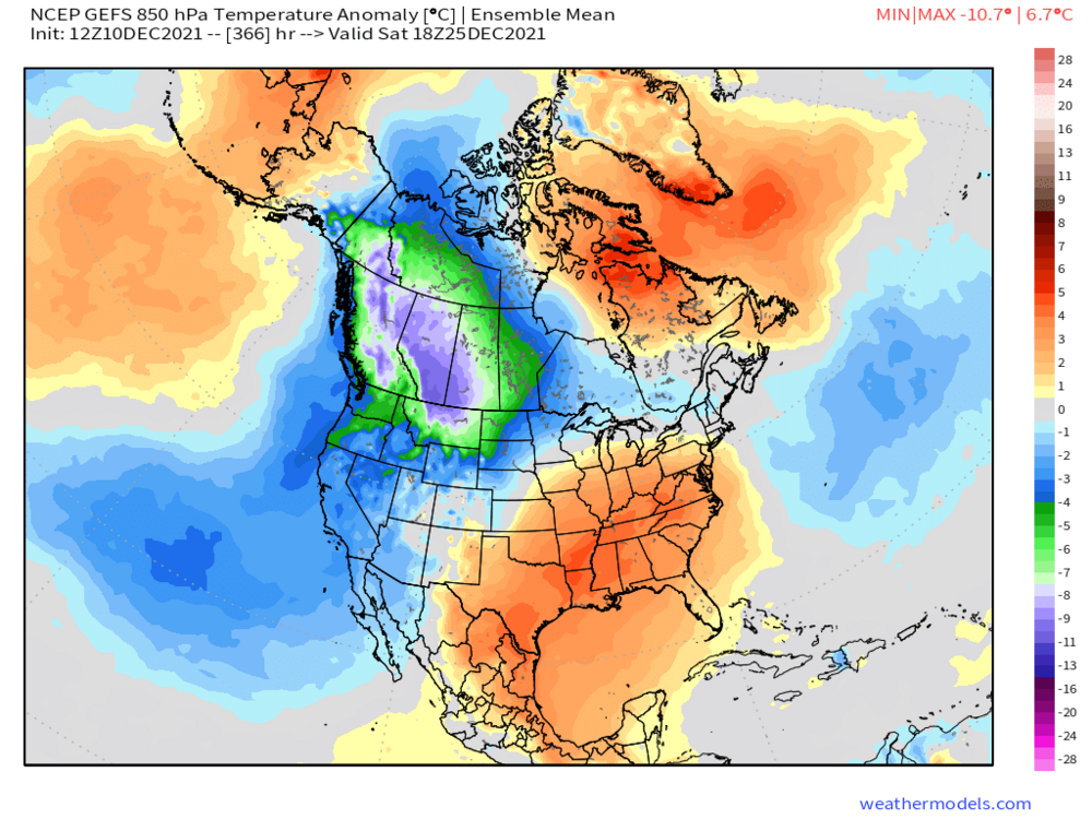
5 minutes ago, ORH_wxman said:
The 850 anomalies show this well...it's not that warm here.
It will be interesting to see if we can not only get but maintain ridging in the Alaska region. The persistent troughing there has been quite impressive along with the degree of cold. It's been a bit uneasy b/c there have been so many times during the earlier fall and even know that this overall scheme would breakdown but it hasn't.
IMO (and I could be totally wrong on this premise since this out well out of my wheel house) but I think in order for us to see any significant and major changes to the overall configuration the changes have to happen across the western Pacific/Asian continent...not necessarily the Arctic. There needs to be a complete overhaul there first and then the rubber band snaps.
-
 1
1
-
-
Obviously H5 is a fantastic level to start at when assessing the pattern and potential evolution but there are times where H5 can be extremely misleading. While there is a strong correlation to evolution of H5 and the sfc the correlation is not 100%. Moving through at least the end of the month just using H5 alone may be one of those times where the correlation is quite small (to the sfc). Point-in-case next week. Examination of the sfc continues to show strong cold high's sliding southeast through Canada (even into our area). While high pressure's obviously aren't good for storms they can supply cold air...so what do we want for storms?
The jet continues to be active with shortwaves which keep coming into the country from the PAC...so if we can keep supplying systems and get some llvl atmospheric support we'll have winter chances...whether it be snow, mixed, or ice.
Point is H5 does not always tell all
-
1
-


December 2021 Obs/Disco...Dreaming of a White-Weenie Xmas
in New England
Posted
Now it’s damage time impressive stuff with that stuff as it went across NY