

weatherwiz
-
Posts
76,428 -
Joined
-
Last visited
Content Type
Profiles
Blogs
Forums
American Weather
Media Demo
Store
Gallery
Posts posted by weatherwiz
-
-
1 minute ago, 40/70 Benchmark said:
Grab a 40oz under that and just touch yourself visualizing the CAPE
If I got under that...I may have to come out of 40 retirement
-
 1
1
-
-
19 minutes ago, ORH_wxman said:
Soundings become extremely unstable.
I mean, this is classic heavy snow sounding from an IVT....I do think there's a decent chance something will set up, but we just don't know where yet.
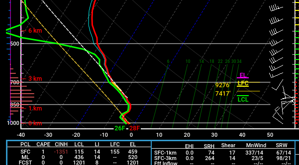
I would suspect ratios would be quite high under that. Probably even maximizing ratio potential too...sufficiently cold through the column, super light winds, and looks like a cross-hair sig too. Maybe ratios upwards of 20:1?
-
Just now, 40/70 Benchmark said:
I agree...its not the start to the season I expected. You are right that the collection data really intensified in October, but TBH, it never stops....
BINGO...it never does stop.
I think alot of the early looks ahead to winter that early (heck probably even going into late summer) stem with those involved in energy demand/forecasting.
But I have to agree...at least from the minimal work I've done with attempting long-range forecasting there is not a whole heck of correlation between fall/winter. Significant changes happen to the northern hemisphere during this period from changing wavelengths to changing correlations between teleconnectors and the overall pattern. Also, you can have significant short-term weather phenomena which can result in a significant hemispheric pattern change. For example, perhaps a significant recurving typhoon in the PAC or a monster ATL storm which completely re-shapes the NAO or a significant stratospheric event.
-
1 minute ago, ineedsnow said:
They think it was someones pet.. its been in the river for months now
how do you have an alligator as a pet? where did they keep it...the bathtub?
do they eat spiders?
-
Just now, ineedsnow said:
lol atleast having no snow or ice has helped the alligator strive in the westfield river by The Bige in west springfield saw on wwlp it was spotted again the other day

wtf?????? how did an alligator get there? great now we have to deal with those.
-
2 minutes ago, ineedsnow said:
are you telling me my accuweather 90 day forecast won't verify
unless that period happens to be right around climo...sadly, probably not

-
1
-
-
Just now, MJO812 said:
Models should go out past 120 hours
The problem is there are too many ridiculous products out there. Past 120-hours...hell maybe even 96 you only need upper-level charts and some SLP progs. No QPF or snow maps or whatever
-
 1
1
-
-
1 minute ago, Lava Rock said:
why do the models suck so bad? I've asked every winter over the last few years why it seems anything more than 3 days out can go from norester, to cutter, to OTS. And like you said, even within 3 days, it can be a crapshoot
I don't know if it's really a case of models sucking. These past few winters we have seen patterns become established which have tended to be progressive in nature which usually is associated with lots of moving parts (i.e. shortwave energy). When you have situations where there are so many pieces of energy and an infinite amount of interactions you get chaos from hell. This is why when looking just at SLP and sfc charts you get tons of different solutions not only from model-to-model but mode run-to-model run...it's a product of the infinite amount of solutions which exist.
-
1
-
-
3 minutes ago, RUNNAWAYICEBERG said:
I wasn’t expecting a Wizzy melt on 12/7 over 1-2”, that’s for sure.
The first few inches of the season are always special...or hell the first storm really. Also knowing what lies ahead with the pattern moving forward we need to capitalize on any chance (no matter how minor) we can get
-
1 minute ago, 40/70 Benchmark said:
I think I have a shot at 2"+ out here...
much better than me.
This is just frustrating b/c you watch the evolution of this from the upper-levels down to the surface and it's close to being a big hit. I' just so sick of this crap though these past few winters. It's almost not even worth monitoring or getting excited for any chance unless you're within 72-hours...and even then you probably get disappointed.
-
1
-
-
This is absolutely ridiculous. So freaking sick and tired of this. Everything just turns to crap. crap...crap...crap. Winter isn't even fun anymore....it's just full of stupid dry cold and then when we get something we torch. This is why social media sucks...everyone going bonkers posting D5-7+ garbage and then sounding alarms b/c there is "good agreement" at D5 and then it all goes to SHIT. Was a nice 2-3'' of snow that much to ask for?????

-
1
-
3
-
 2
2
-
-
May as well just start a damaging wind threat for Sunday at this juncture
-
 1
1
-
-
3 minutes ago, DavisStraight said:
So its good for Nova Scotia?
Always is
-
This is going to be super, super close. This is going to end up becoming a pretty impressive storm but does everything happen in time? There is just so much moisture and upward motion. If we can even get things to time like 6-hours earlier which isn't farfetched. This is such a beautiful ULJ structure. Wish it would unfold to this like 100-miles west

-
 1
1
-
1
-
-
Also watching that energy off the SW coast there...that has implications on that ridging into the Inter-mountain West. Conceivably, stronger ridging in the Inter-mountain West could influence a sharper trough/more digging and earlier
-
32 minutes ago, dendrite said:
18z, but I haven't seen it.
Based on Anthony's post you almost wonder if the 18z Euro got caught in the Buffalo wind
-
1
-
2
-
-
GFS just seems a bit flatter with the trough. but as stated...it's a definite improvement from before. I take that as a win
-
1
-
-
First call.
Lots of positives here for sure! Could certainly trend in either direction but definitely loving the signals which are trending in a favorable direction

-
1
-
1
-
-
3 minutes ago, 40/70 Benchmark said:
I get that on chrome alot... click advanced and bypass it
sometimes I don't get that option.
I wonder if it happens on other browsers
-
Working on a snowfall map now...would wait until after 0z tonight but I'll be watching the Pats and probably a few beers deep.
But general thinking is 2-4'' southern CT and 1-3'' rest of state. I could certainly see some 5'' potential is favorable trends continue
-
Just now, Baroclinic Zone said:
I wish Pivotal had an easier way to toggle between runs like TT has. It's slower and cumbersome on Pivotal.
cod is pissing me off with these stupid "this site can't provide a secure connection errors"
I love cod b/c it has a ton of different parameters and is the easiest to maneuver.
-
1
-
-
skimming through some soundings there is also a decent unstable layer in there around 850mb or so. could be a fun few hours under the band (for whoever gets in)
-
There would most likely be a narrow band of moderate-to-heavy band of snow given this look. Would probably pass along southern CT, RI, and far SE MA
-
1
-
-
Just now, Sey-Mour Snow said:
18z HRRR is NW like the NAM is too
Yup! I feel a bit better now
Was looking at NAM when I thought I was looking at the HRRR
I always love when the HRRR gets into range (even if it's at the 48-hour mark) b/c it can really be useful when spotting and assessing for trends.

Wednesday 12/8 Possible Snow/Ice/Rain? Discussion
in New England
Posted
Yup...that's the challenge with these things. Incredibly difficult to pinpoint where they occur and sometimes even when modeled they don't materialize as so