weatherwiz
-
Posts
81,336 -
Joined
-
Last visited
Content Type
Profiles
Blogs
Forums
American Weather
Media Demo
Store
Gallery
Everything posted by weatherwiz
-
 In Windsor and getting a hefty downpour currently
 -
I was hopeful we could sneak in another period of very hot temperatures into the region towards the end of the first week of August but not so confident on that anymore. Seems like the more favorable look is now pushed out into the second week. And when you have to start chasing dates...never usually a good thing, especially when working downhill from peak climo.
-
Not so sure about that Some of the maps being posted around makes it seem like Noah needs to make another appearance from heaven Great to be getting some of these setups lately. Giving people much needed rain without the concern for significant flooding issues. I know there was the flooding within SW CT last week but these events are perfect to tackle the deficit without cause for major concern
-
There is still a quite a bit of uncertainty in how the whole thing evolves for sure. I mean if you look at the latest NAM's, there is actually some potential we get enough drying and maybe even some breaks of sun tomorrow (especially in CT) that we could pop isolated thunderstorms with potential for localized damaging wind gust or even a brief tornado. I was thinking the greatest max would be west of here...Hudson into NJ but its possible you may see the max zone be something like northeast CT into northeast MA and southern NH and then a few local maxes elsewhere.
-
Seems like the initial slug of heavy rain is trending a bit more progressive in nature and then its more of a daytime heating, convectively driven pop up showers/thunder during the day tomorrow and Thursday. We'll see if that slug can get a widespread 1-3" of rain but anything exceeding that is going to be quite localized and tied into convection. A good soaking rain for the ground
-
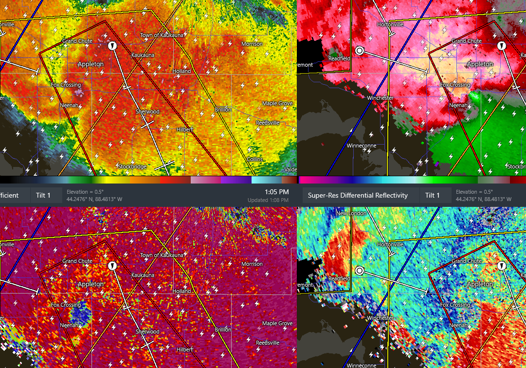
If I was an observer at the airport and a tornado was headed towards the tower I'd stay until the very end and the last thing I would do is issue a SPECI and in the remarks say, "About to Die"
-
we'll get a widespread 3-4" of rain and still see the drought monitor go up a level next update
-
the flood watches have flown
-
Hoping there are no injuries or fatalities. That looks awful EDIT: well no fatalities, I see injuries reported
-
ATW gusted to 45 knots. No report of funnel or TOR in the METAR but looks like it may have formed extremely close to the airport or passed by very close
-
yikes

-
Next week is going to be great when we pump in 70+ dews
-
ahh yeah I didn't check the 3km yet. Something like that is exactly what I am trying to envision happening. You can see too how that really hammers the lower Hudson down to around Newark...could be some serious flooding down that way.
-
Someone for sure, but how widespread of an area? That's what I'm a bit iffy on. Could be the Berks that get smoked in this.
-
That's cute Love how the bullseye is right over me. That's how you know it isn't happening But looks like the NAM wants to pump the fire hose Wednesday night. Still seems a quite a bit overdone
-
ehhh this isn't looking that impressive for widespread significant rainfall totals. Greatest concern for several inches of rain is going to be the Hudson Valley into NJ tomorrow into the overnight but as the system continues sliding east its going to begin occluding. Also seems like there are two warm fronts with this...we get a diffuse warm front maybe into southern CT and dynamics are solid...so we're going to see rain but it should generally be light-to-moderate and a bit more on the spotty side with heavier rain tied into convection. The true warm front seems to get pinched off well south. There will be some wild gradients with totals...some spots will probably see 2-3-4" of rain (but really spread out over multiple days) and some spots may struggle to even get an inch. All in all, a nice good soaking rain for some, perfect because the ground can easily absorb it and limit any major concerns for flooding. Could be big flooding through Hudson Valley into NJ
-
I wonder if we can muster up a sunrise surprise setup across Long Island or coastal CT/RI early Wednesday morning
-
I think too alot of how this evolves is tied into how the convective scenario evolves today within the Great Lakes/Ohio Valley which remains quite complex
-
Agreed on this. You can see that hinted at just looking at how the mlvls evolve. This is more like a cool season evolution than something we usually see in the warm season. Just looking at 700 RH you can see the idea of two jack zones and where
-
I don't know if I see much flooding potential outside of any typical flood-prone areas that flood if it precipitates for more than 5 minutes. A lot of this is drawn out over multiple days and ends up being more convective in nature. There will be a good slug of rain early on in the setup with the warm front or even triple point but this looks to occlude rather quickly. Any flooding risk probably confined to (if) any areas that are hit with several rounds of convection.
-
love how this tiny spec of green gets right to where ineedsnow is
-
Agreed
-
the heat will always find you
-
Gotta be extremely careful here just rip and reading total QPF maps. It might be difficult to get widespread amounts as modeled. The axis of highest totals is going to be confined to where the warm front is located and this will be a narrow axis. Also potential for this to close off to our west which would introduce dry slot concerns. Going to be a quite a bit of convection though so there are going to be some areas that probably get smoked, but we may see some drastic differences in precip. amounts across the region when all said and done. There should be some concern though for some significant flash flooding but how widespread?
-
Certainly looks like there will be some risk for strong-to-severe storms