weatherwiz
-
Posts
79,817 -
Joined
-
Last visited
Content Type
Profiles
Blogs
Forums
American Weather
Media Demo
Store
Gallery
Everything posted by weatherwiz
-

Blowvember - and not named for wind potential
weatherwiz replied to Go Kart Mozart's topic in New England
1000% -
Blowvember - and not named for wind potential
weatherwiz replied to Go Kart Mozart's topic in New England
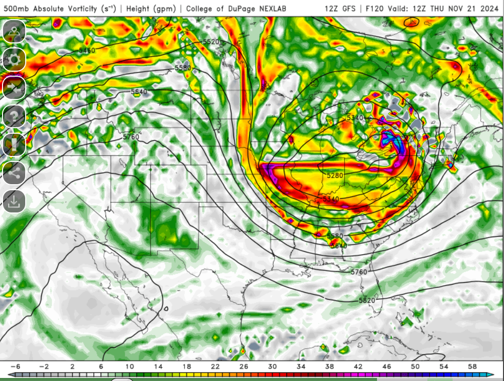
This is the 500mb level and is displaying absolute vorticity and the height, in meters, the 500mb level can be found at
-
Blowvember - and not named for wind potential
weatherwiz replied to Go Kart Mozart's topic in New England
Getting a bit excited for Thursday. Wouldn't be surprised to see a marginal risk with the D3 which comes out overnight Monday as long as things hold pat. -
Blowvember - and not named for wind potential
weatherwiz replied to Go Kart Mozart's topic in New England
Umm how about both -
Blowvember - and not named for wind potential
weatherwiz replied to Go Kart Mozart's topic in New England
Actually probably not, the Sun will be on the other side of the house and it will get chilly shaded over. Damn you cold -
Blowvember - and not named for wind potential
weatherwiz replied to Go Kart Mozart's topic in New England
Might watch the Bruins game outside today -
Blowvember - and not named for wind potential
weatherwiz replied to Go Kart Mozart's topic in New England
The upper evolution is interesting, that's for sure. I just question whether we have enough to yield a widespread synoptic rain. There undoubtedly would be a great deal of upward vertical motion but we may be lacking one key ingredient...and that's moisture to really lift. The greatest combo of lift/moisture would be on the leading edge of the dry slot with the cold front where you have also a narrow wedge of instability. We'll see what happens though, I would not be shocked if we see an entirely different presentation come Sunday. -
Blowvember - and not named for wind potential
weatherwiz replied to Go Kart Mozart's topic in New England
end of week? -
Blowvember - and not named for wind potential
weatherwiz replied to Go Kart Mozart's topic in New England
One thing I really hate seeing is we've seen a constant barrage of systems closing off and occluding across the Ohio Valley region...this has been a transition season theme for the better part of the last few years (more like 3-4). It doesn't seem to matter what the ENSO phase/strength is or what is going on in the Arctic, the regime favors closing off/occluded systems in the Ohio Valley. I think this goes way beyond Arctic/N PAC domain and what is going on with NAO/AO/PNA, etc. One thing I wished you more of out there is research that didn't center on using physics and calculus to prove what is going on. I mean don't get me wrong, that component is critical, especially when it comes to modeling but I feel like alot of ideologies we have which center on how ENSO and teleconnections factor have not evolved much as these databases grow. -
Blowvember - and not named for wind potential
weatherwiz replied to Go Kart Mozart's topic in New England
A combo of those three would be phenomenal. One negative about COD too which I forgot to mention is it is not mobile friendly...at all. Several years back I believe a husband and wife had developed a mobile version and it was in the beta stages and there was an app...it wasn't bad. But I believe they ended up getting divorced and it died. I wonder how much better cod will become. What helps them is its the College of DuPage which developed it so 1) As long as they continue to receive adequate budget funding 2) If you're a student there and interested in modeling and development, what a freaking phenomenal opportunity to have. Imaging putting on a resume you helped build/develop products? 3) Also being freely offered - they probably aren't as cocky as some of these private vendors who all they care about is generating revenue and are going to create products to suck in the weenies. -
Blowvember - and not named for wind potential
weatherwiz replied to Go Kart Mozart's topic in New England
If that end of the week evolution pans out like what is modeled, we could see a pretty decent line of convection develop and move across the region. That's a nice narrow ribbon of instability on the GFS in the warm sector. -
Blowvember - and not named for wind potential
weatherwiz replied to Go Kart Mozart's topic in New England
It was my favorite part of wxbell. -
Blowvember - and not named for wind potential
weatherwiz replied to Go Kart Mozart's topic in New England
Then you definitely can't go wrong with cod. Probably one other aspect of wxbell that is underrated (I don't have it but school used to have a subscription so used it there) is its extremely user friendly navigating products, models, and comparing between models. While cod is great it involves alot of clicking around. -
Blowvember - and not named for wind potential
weatherwiz replied to Go Kart Mozart's topic in New England
yeah I remember that being a thing about them. I think i had SV way back in the day and the graphics/color schemes were brutal. Looked like something Kevin would spit up after one too many IPAs. -
Blowvember - and not named for wind potential
weatherwiz replied to Go Kart Mozart's topic in New England
What are you looking for really? Just day-to-day forecasting or more long-range? You really can't go wrong with cod, especially if you're looking for more day-to-day or more interested in when we have a potential storm. Cod and then complimenting bufkit for specific locations. I wish Cod had more products for HRRR/ability to generate soundings and I wish they had more products for ensembles but for a free site, its easily the best. -
Blowvember - and not named for wind potential
weatherwiz replied to Go Kart Mozart's topic in New England
forgot about that site -
Blowvember - and not named for wind potential
weatherwiz replied to Go Kart Mozart's topic in New England
It would be great if there was a wider selection for option, especially for winter weather forecasting. The winter weather selection just consists of snow maps, Ptype, and sleet accumulation. They have the basics for each level but I think COD (which is free) is far superior and has much better graphics...must easier visually. For $10/month it isn't bad because that comes with access to city charts and forecasts for teleconnections. I do like the EPS products for tropical and what they have for ensemble information but I think something like Ray mentioned, f5 plus weatherbell is the better route to go. -
Blowvember - and not named for wind potential
weatherwiz replied to Go Kart Mozart's topic in New England
weathermodels.com sucks -
Blowvember - and not named for wind potential
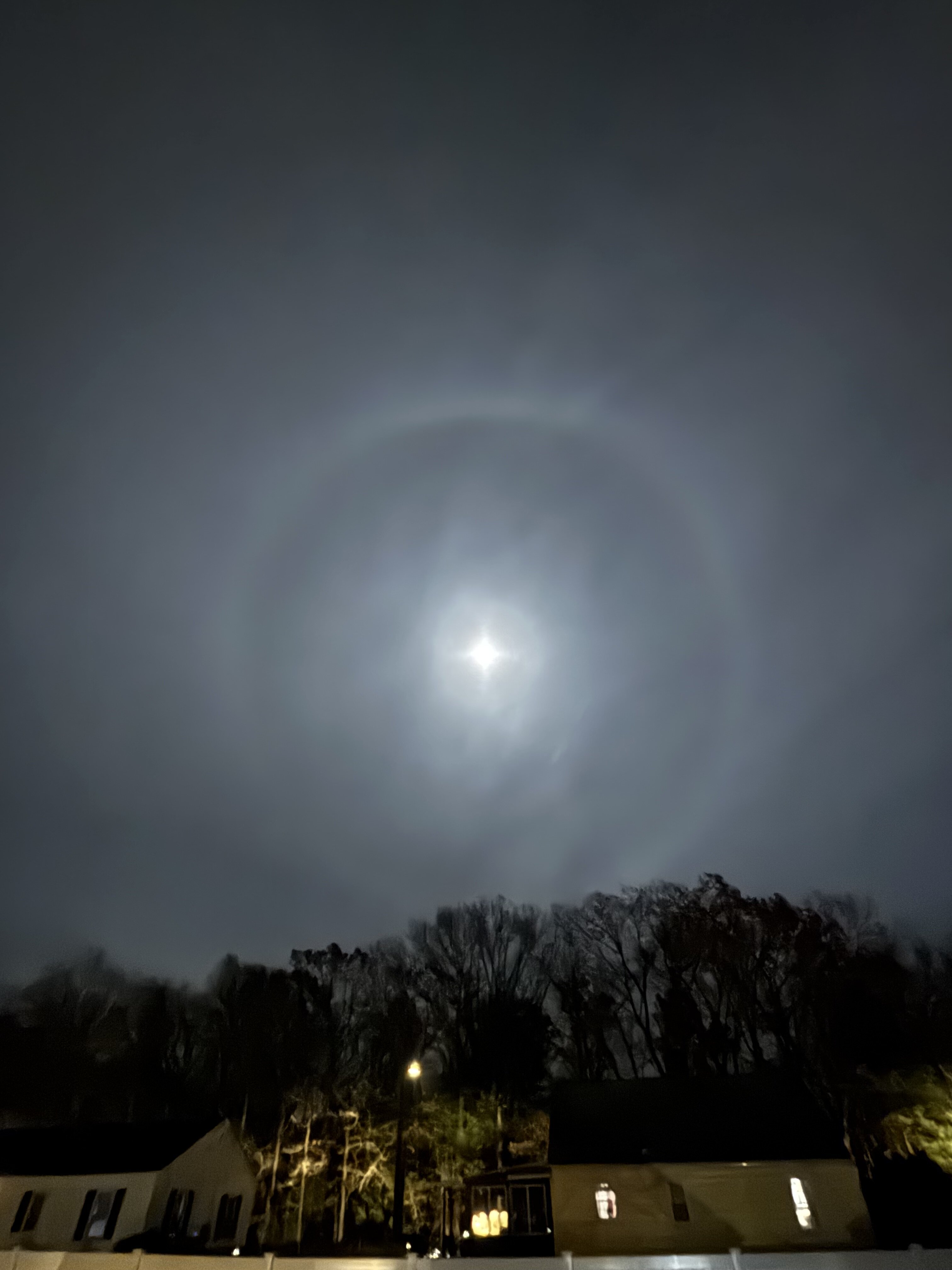
weatherwiz replied to Go Kart Mozart's topic in New England
Crazy how vibrant it is...not like the picture is adding effects. -
Blowvember - and not named for wind potential
weatherwiz replied to Go Kart Mozart's topic in New England
Giant halo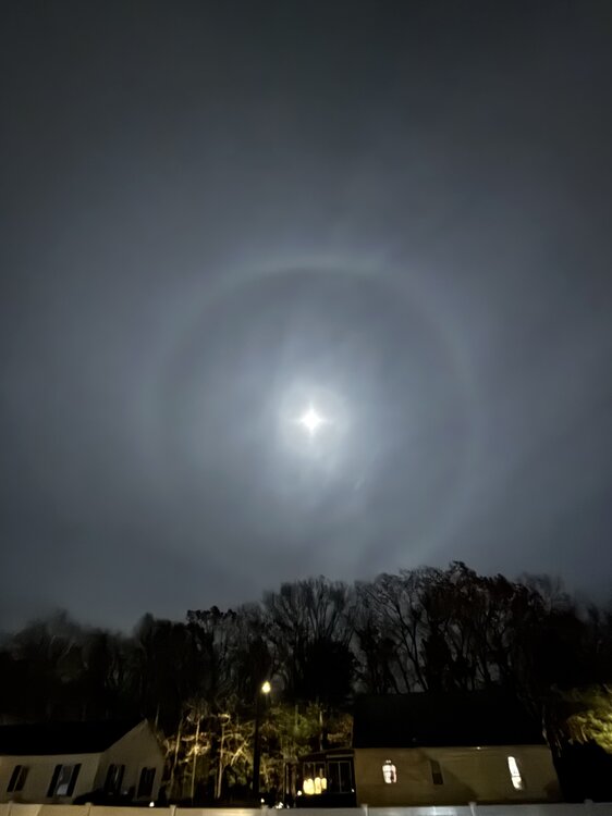
-
Blowvember - and not named for wind potential
weatherwiz replied to Go Kart Mozart's topic in New England
Too many emojis. It takes like an hour to find the right one at the bottom. Pretty soon the length will span the width of the monitor. -
Blowvember - and not named for wind potential
weatherwiz replied to Go Kart Mozart's topic in New England
whole NWS must be having some major issues today -
Blowvember - and not named for wind potential
weatherwiz replied to Go Kart Mozart's topic in New England
Who would have that the area of convection in the far southwest Caribbean would become the main player lol. But I'm not so sure we can really call this one a fail, obviously with no low-level circulation [until yesterday afternoon] guidance is going to really struggle. If that main circulation formed around Jamaica/Cuba (like south of Cuba) where that initial burst of convection occurred, this would be a much different story for Florida, IMO. -
Blowvember - and not named for wind potential
weatherwiz replied to Go Kart Mozart's topic in New England
The brunt of the cold is all bottled up on the other side of the hemisphere. Need to get it to this side, otherwise who cares what the NAO, AO, EPO, PNA, WPO are and what combos you have. Without the combos we are flooded with warmth and with the combos we're barely avg. -
Blowvember - and not named for wind potential
weatherwiz replied to Go Kart Mozart's topic in New England
wow...was looking at the 12z GFS and thought to myself, "oh wow that's a decent cold shot in about 7-10 days" looking at 850/925...was curious as to what the sfc looked like...no cold just somewhat avg times with the most below avg temps across the OV into the SE.