

weatherwiz
-
Posts
79,817 -
Joined
-
Last visited
Content Type
Profiles
Blogs
Forums
American Weather
Media Demo
Store
Gallery
Everything posted by weatherwiz
-
It was not a pleasant ride up 91 with some big gusts of wind…had to clutch the steering wheel tightly
-
This wind is nuts. This may be the windiest evening this winter
-

Tracking February 6. Light to moderate event potential
weatherwiz replied to Typhoon Tip's topic in New England
That would royally suck -
Tracking February 6. Light to moderate event potential
weatherwiz replied to Typhoon Tip's topic in New England
This is essentially a 2-3 hour (3 hours probably even stretching for some) humpity, thumpity of snow followed by some light-to-moderate IP (and some ZR in spots) which will make road conditions even worse and clean-up not so fun. -
Tracking February 6. Light to moderate event potential
weatherwiz replied to Typhoon Tip's topic in New England
Agreed -
Tracking February 6. Light to moderate event potential
weatherwiz replied to Typhoon Tip's topic in New England
It's pretty impressive seeing how cold MOS/NBM is for tomorrow night...even down in place like EWR/JFK. -
Tracking February 6. Light to moderate event potential
weatherwiz replied to Typhoon Tip's topic in New England
Thursday morning and afternoon commute will be brutal...roads are going to become a disaster quickly. -
Tracking February 6. Light to moderate event potential
weatherwiz replied to Typhoon Tip's topic in New England
I would probably even go a couple hours prior to Sunrise for start. Maybe even as much as 3 hours. -
Tracking February 6. Light to moderate event potential
weatherwiz replied to Typhoon Tip's topic in New England
This is some impressive WAA...there is certainly going to help with a big thump of snow on the front end.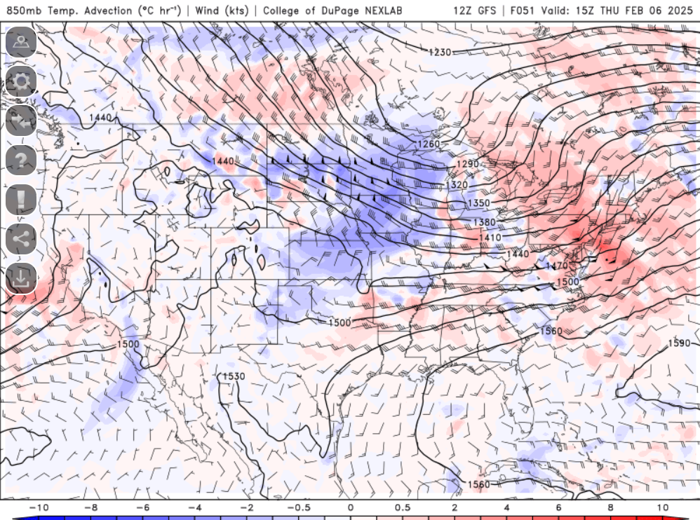
-
Tracking February 6. Light to moderate event potential
weatherwiz replied to Typhoon Tip's topic in New England
I'm starting to think I can pull of 4". If I add the 2.5" from yesterday that would be 6.5"...that would be 10.8% towards my goal of 60" between yesterday's event and mid-March. -
Tracking February 6. Light to moderate event potential
weatherwiz replied to Typhoon Tip's topic in New England
Outside of right along the CT/RI coast and far SE MA...i think everyone stays below 32 for the event and even coastal CT/RI may barely get above 32 -
Tracking February 6. Light to moderate event potential
weatherwiz replied to Typhoon Tip's topic in New England
I was just going to mention that. I don't see anything arguing for a surge of warmer temps at the sfc -
Tracking February 6. Light to moderate event potential
weatherwiz replied to Typhoon Tip's topic in New England
These setups tend to be quicker versus slower for precip. arrival so I am almost inclined to side with the NAM timing wise. -
Tracking February 6. Light to moderate event potential
weatherwiz replied to Typhoon Tip's topic in New England
Might not be totally useless right now though...it may be correct on the timing side of things. The differences in timing amongst some of the models right now is wild. -
Tracking February 6. Light to moderate event potential
weatherwiz replied to Typhoon Tip's topic in New England
I'd buy it...lift is looking much better and that's some very strong WAA. Plenty of moisture being thrown into a cold antecedent airmass. -
Tracking February 6. Light to moderate event potential
weatherwiz replied to Typhoon Tip's topic in New England
I just got through looking at some soundings...maybe the freezing rain isn't much of a concern as the main ptype outside of snow may be sleet...though I do wonder if just inland of coastal areas would stand a chance...this is where there is a better chance of warming the llvls enough while the sfc stays below freezing. -
Tracking February 6. Light to moderate event potential
weatherwiz replied to Typhoon Tip's topic in New England
Forecast soundings are pretty wild. Good support for a pretty solid burst of snow for just above everyone (even coast) and probably even enough for something like 3-4" then its an interesting transition of precip type...some areas (especially inland) may flirt with sleet/snow depending on lift/rates. Some soundings looks pretty unstable too. -
Tracking February 6. Light to moderate event potential
weatherwiz replied to Typhoon Tip's topic in New England
Probably going to be a very narrow area but there may be some spots looking at a decent ZR event. This is going to end up on the colder side in terms of sfc -
Fixed
-
I am now hoping for 60" of snow between now and mid March...raising from 50". In fact, I'll count last night so technically I only need another 57.5".
-
Excellent post! Maybe the data will prove me wrong here but I am not the snow climo encyclopedia like Will is, but I would think that more often that not, our winters which are either average in terms of snowfall or maybe a standard deviation higher are composed of numerous small-to-medium sized events. If you want to talk about the upper echelon of winters (your top 3) that's when you need to get multiple large events along with numerous medium sized. But your point about the deltas...this can't be overstated and quite frankly, isn't discussed enough. Too often things are looked at in a static state...the NAO is this, the PNA is that, here is what the D7-10 500mb mean shows...the static state doesn't matter, it's the delta...it's what is going on between time point A, time point B, time point C, ..., etc. that ultimately matters. It's understanding how these deltas are all contributing to the shape and make of the pattern and then incorporating smaller-scale and even mesoscale features which influence the evolution on the shorter time scale.
-
Yup...we don't see stretches like what is being modeled too often. This is what makes winter to me...I would rather have several small-to-medium sized small events versus one large one. I know that is one of the bigger debates here but we endure a long cold season across these parts...may as well spread the wealth around. Several medium sized events can rack up the seasonal totals quickly.
-
Let's just fire the cannons right through February. I love active February's...by this time I am definitely ready for Spring/warmer weather so when you get an active February you 1) Are getting nailed with snow which is fantastic 2) It makes the time go by faster This pattern is like the equivalent of the ring of fire pattern during the summer...as Tampa Bay Bucs fans say, "FIRE THE CANNONS"
-
Sunday Evening/Night Light snow event Disco/Obs
weatherwiz replied to Sey-Mour Snow's topic in New England
About 2.5” here or so. We all white again -
We’ve made it to February. Only two full months to go 89 days


