weatherwiz
-
Posts
81,150 -
Joined
-
Last visited
Content Type
Profiles
Blogs
Forums
American Weather
Media Demo
Store
Gallery
Everything posted by weatherwiz
-
Staying at a hotel!
-
It’s now any event should be
-
At an open bar wedding so I’m open baring and thinking of Kevin and heat Kevin and you know what…he warned everyone. If you haven’t installed yet, I’d say I feel bad for you but I don’t. He warned you and now you have to rush to install. If you just installed weeks ago like he said all you would have to do is push a button. Now you have to struggle and push a button. Lessons learned people
-
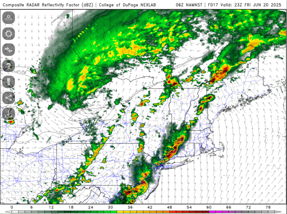
Obviously the timing of an MCS is in question but lets say we're looking at a window where something could develop along a residual outflow boundary...it's probably a very small window...like 10 AM - 1 PM. The extreme instability is going to be sick to see here, unfortunately, it means nothing without a lifting mechanism.
-
One of these years we'll rip a good derecho through again
-
Late overnight and tomorrow morning is going to be 100% nowcast. If we can sneak the instability gradient a bit farther east we could see something roll through but this may be just too far west. If anything can form along a residual outflow boundary (again west) later in the day...that sucker could be huge...will have rising heights to contend with though
-
When I went to Florida my first time ever 3 years ago to visit my girlfriends parents we flew into FLL…when I hit that wall…it was amazing.
-
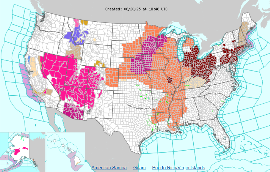
All these advisories for heat and here you have winter advisories in Montana and Idaho
-
It's extremely intriguing. These type of setups are absolutely brutal to forecast in the northern Plains/upper-Midwest (where I think they are "most common") so imagine how much of a pain for us. Obviously there is going to be a hell of a cap in place plus we will have heights rising...but this could be offset a bit in a NAM solution. But this is something where if you're just looking at QPF alone...you could totally miss/disregard any convective potential and all of a sudden inside 12 hours mesos start going wild.
-
Sunday has to be watched closely though. Either with MCS timing or if the MCS is north any outflow acts as a boundary but that is about as volatile of an airmass you'll see here with tremendous shear.
-
Crap had a spider crawling on my leg. This is why I hate shorts...they expose skin. I felt something on my leg and thought it was one of those weird looking flying white things so I slapped it off and then saw it starting to crawl and it was a spider.
-
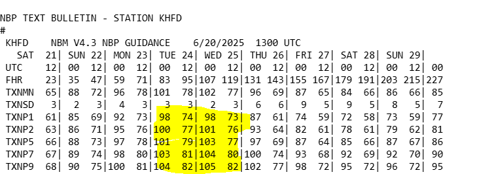
What I think also gives this more support is the NBM doesn't look to be overmixed wither...still has upper 60's to lower 70's dewpoints. The NBM tends to be lower with dews. I guess though if we end up seeing dews more 72-73 versus say 68-71 then we may be more 99ish versus 101-102ish.
-
Here are the percentiles. This is a pretty damn good signal for highs to get into the 100's in the hottest spots. Not sure how much this applies to our area but in these anomalous heat patterns...those 70th-90th percentiles usually work out. This has with some of those big heat events within the West anyways...again not sure if that can be applied here.
-
I'm waiting for some trees/limbs to start snapping.
-
Brutal. The 3km pretty much nailed the whole evolution in the midwest the day prior while the HRRR was awful...I thought maybe that was a good omen for yesterday...nope. The pre-frontal really screwed us yesterday and not having the steep lapse rates as advertised. Maybe if we did have the steep lapse rates that stuff with the pre-frontal would have been more intense.
-
These gusts are insane. Have to be gusting 40-45
-
Clouds quickly leaving here...getting into strong sun now!
-
ahhh...I thought that looked extremely odd when I saw that. I didn't catch there was an error.
-
I was shocked seeing this

-
Could be a wild evening and early overnight that way, probably a 1-2 hour window for some big TORs too.
-
It actually kind of sucks. Figured I'd work outside and wear shorts today but its cloudy and cool. Put on a little light jacket and may have to switch to long pants.
-
3km has some violence later today
-
so the HRRR screws up in the midwest but then it ended up being spot on for here (talking about how yesterdays runs didn't show much). SCREW YOU HRRR
-
eh screw it...just going to go home. nothing else looks like it is popping and the stuff going on is coming down
-
Not a bad idea, but traffic may be miserable getting there lol