weatherwiz
-
Posts
79,817 -
Joined
-
Last visited
Content Type
Profiles
Blogs
Forums
American Weather
Media Demo
Store
Gallery
Everything posted by weatherwiz
-
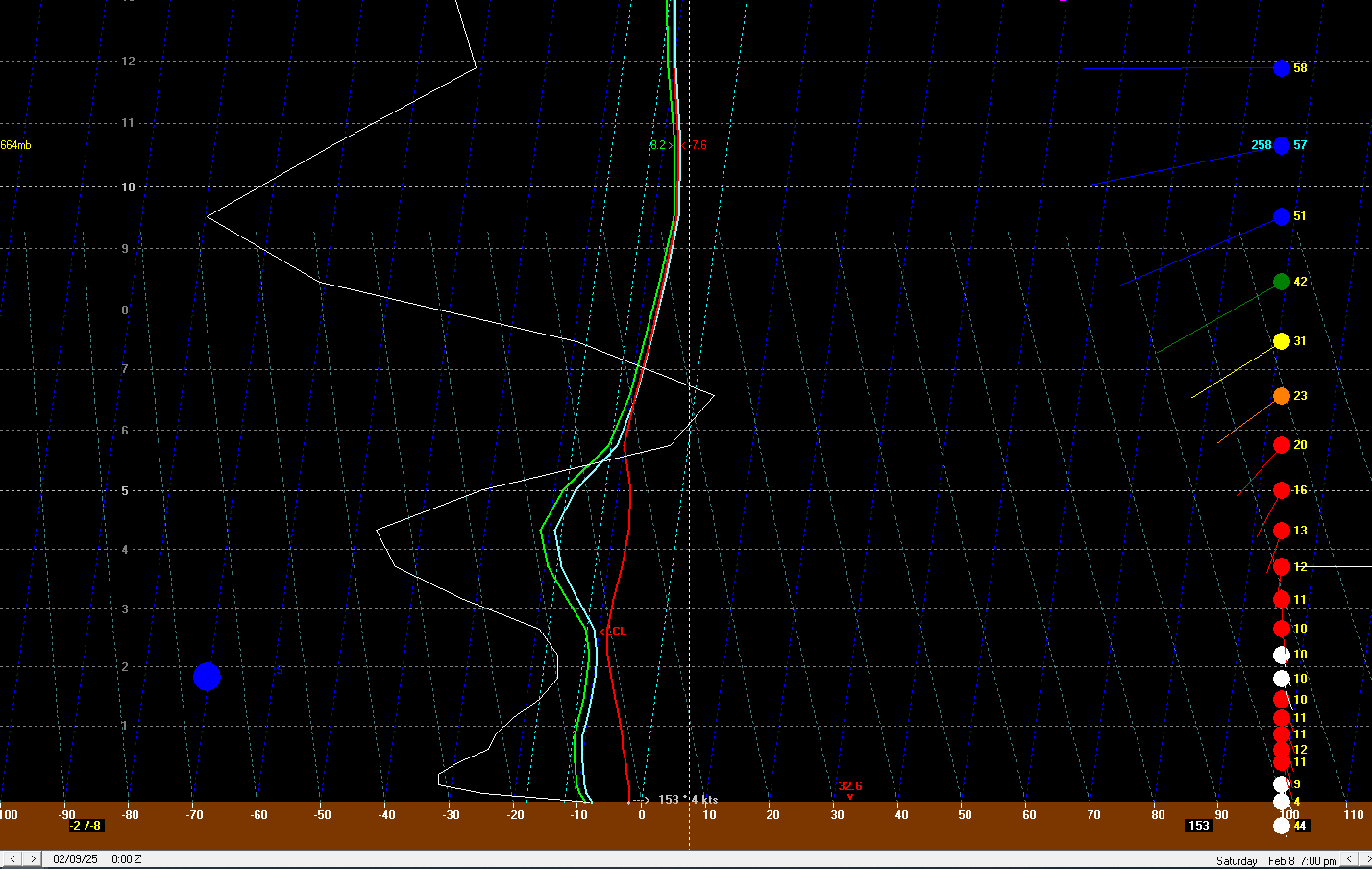
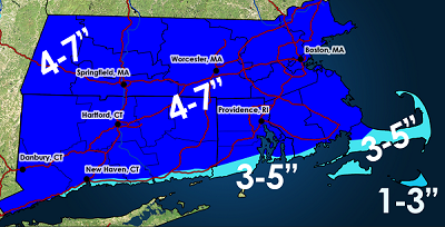
 Well here is the 12z GF bufkit for BDL. I'll just stick with my 4-7" forecast though I think 4-5" amounts will be the more common across Connecticut with the best chance for 6-8" totals northwards (like where Scott mentioned). But you can see that the window for heavy snow/highest rates is confined to a very small window and and outside of the greatest lift there isn't a whole heck of a lot.
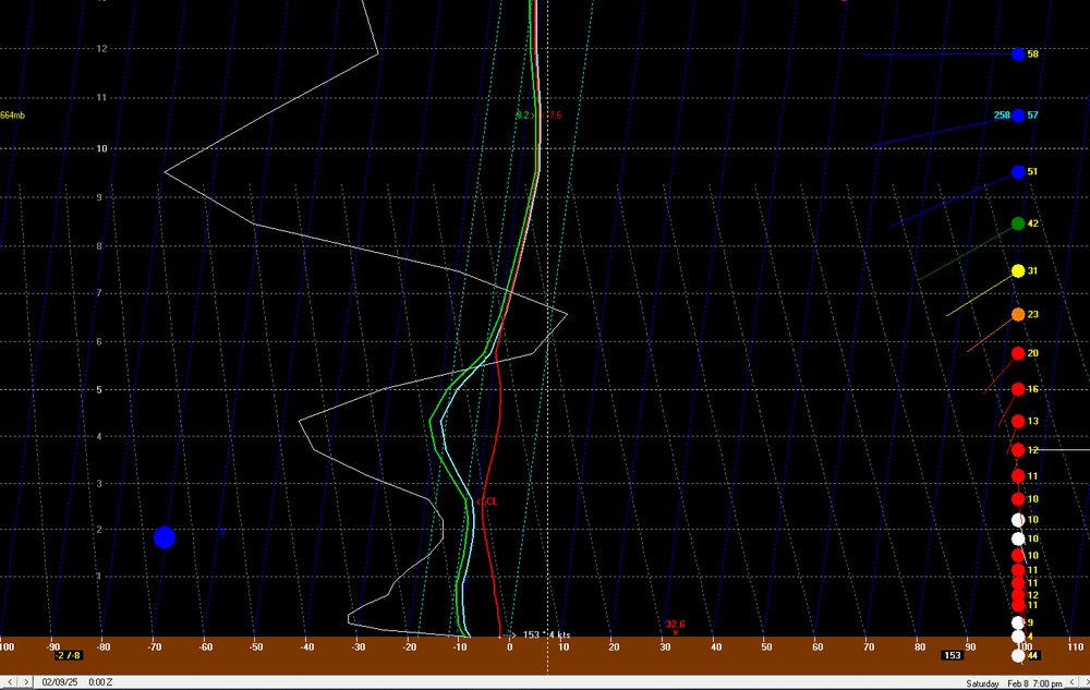
-
That's true but for those in the snow removal business or planning...that is a big difference. I am not involved in that vertical but I have a few friends who do snow removal and one will ask me for some thoughts here and there. He says when he sees ranges like 2-5" or even something like 4-8" or 5-9" it can make decision making difficult for him...planning on how many people to call in, exactly what type of equipment to use (including using plows on trucks), how much sand/salt, etc. He says the worst is the 2-5" range because that is the difference in just using shovels versus needing snow blowers and extra gas.
-
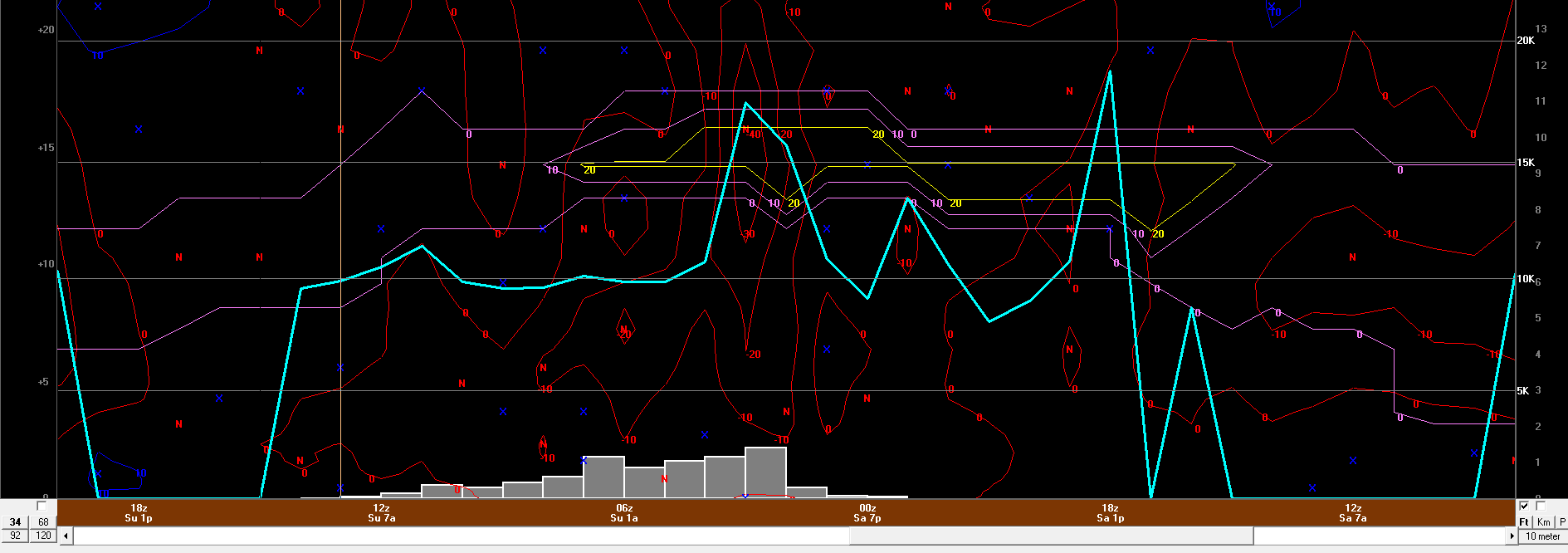
IMO, 6" is the ceiling for most. Anything above 6" will be the result of getting under multiple heavier bands. I think 4-5" amounts will be the most common across the board, but those areas that get lucky will end up with the 6-7" totals but that won't be widespread, that will be confined to a specific area. I mean looking around any various soundings on bufkit outside of the heavier fronto band the upward vertical motion is not particularly great. Now, the DGZ may be just low enough to where that could help compensate some but when I am looking at bufkit soundings and looking at omega, coupled with the DGZ and the snowfall ratios, I am asking myself, "what is the snow growth going to look like and what will the rates be"? Under the fronto band...1" per hour is obtainable but outside of that...may be lucky to push 0.50" per hour. Also, look at the duration of the lower omega values into the DGZ...its an extremely small window. WAA induced snow without a stronger forcing mechanism typically does not bode well for creating dendrites which accumulate efficiently.
-
6z gfs bufkit certainly argues this for Connecticut looking at multiple locations. If I have energy/time later today I'll probably make a revised map and drop the 4-7 to 3-6. There probably will be some 6-7" totals though, maybe north...difficult to say because that will be tied into the H7 fronto banding.
-
ehhh...if one takes the time to really digest everything, assess forecast soundings, evolution of low-levels and mid-levels, and then applying knowledge of these setups well there are plenty of flags which show what you're suggesting isn't far-fetched. Every single weather system is going to have flags and its important that flags be pointed out and assessed to determine what impact those flags would/could have. More often that not, red flags are going to have some impact on what occurs, otherwise every single weather system would overperform.
-
We seem to have short memories and aren't great at learning from mistakes. Or we get too caught up in stuff like QPF and then of course tossing in snow maps like they're worth a damn. But something of 2-4 somewhere is absolutely 100% doable. It's also not like we're getting several hours of intense lifting through the DGZ and even looking at bufkit soundings, outside of the periods where you're maximizing lift the snow ratios aren't anything spectacular. Outside of maximizing lift, snow growth and ratios will probably be meh. I promise you'll see several posts commenting how awful they are.
-
I feel kind of dumb. With the other day system I think it was @HoarfrostHubb who made a comment saying one of the models might be overdone with QPF but I said I think it was right...I didn't end up following the whole evolution too closely but I am going to guess that was overdone with QPF. Anyways, my point is, when looking at this setup it's important to understand what mechanisms are involved for the QPF production. We do have the strong diffluence aloft which is helping to net some upper-level divergence, but the overall driver here in QPF production is probably the WAA and llvl frontogenesis. That may and should yield some caution, not just with total QPF but QPF structure and how that QPF is being utilized (i.e. we're going to have to relay on pockets of enhanced VV to maximize snow growth and ratio). damn it...I should have went 3-6...maybe 3-5.
-
We get too quick to toss the NAM, especially when its shows what we don't want to see.
-
I am a little nervous about my widespread 4-7" forecast...I was debating on doing 3-6"...I know there really isn't a difference between the two but when you look at the "how you're getting there" and the mechanisms involved, IMO there is a bit of a difference between the two.
-
Getting a cute little snow flurry right now
-
edited
-
Well 2.5” from the other day, I didn’t get a chance to measure today but eyeballed probably about an inch (maybe 1.5”)…but I’ll call it an inch. so that’s 3.5” since Sunday. If I can pull off the 7” in my 4-7” forecast that brings me to 10.5”. would only need 49.5” to hit my goal of 60” for this stretch by mid March
-
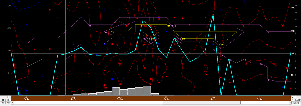
Well got the opportunity to dig deep into the details for Saturday into Sunday. Ultimately, one concern I have for higher totals is just the forward speed and the duration the best lift/maximized snow growth is. I could end up seeing some 7-10" amounts possible though but not widespread enough to map and that will be tied into very localized areas of enhanced lift. https://weatherwiz.blogspot.com/2025/02/february-8-9-2025-southern-new-england.html
-
Tracking February 6. Light to moderate event potential
weatherwiz replied to Typhoon Tip's topic in New England
Think we're getting freezing rain now. -
Tracking February 6. Light to moderate event potential
weatherwiz replied to Typhoon Tip's topic in New England
well technically you're right, it is rain. It doesn't fall as freezing rain, the freezing occurs when it comes into contact with a sfc. -
Tracking February 6. Light to moderate event potential
weatherwiz replied to Typhoon Tip's topic in New England
I wonder if that convection down in Kentucky had a negative impact for us. Convection down that way ended up being a bit more pronounced and stronger than anticipated. -
Tracking February 6. Light to moderate event potential
weatherwiz replied to Typhoon Tip's topic in New England
Basically pixie dust out there right now....yuck. It's the Tampa Bay Rays 2008 season outside -
Tracking February 6. Light to moderate event potential
weatherwiz replied to Typhoon Tip's topic in New England
I remember being burned way too many times not buying the warm tongue haha. One big case was the PDII in 2007 (or was that PDI?) -
Tracking February 6. Light to moderate event potential
weatherwiz replied to Typhoon Tip's topic in New England
I've always thought that way too, however, I've changed my stance on that thinking. Obviously everyone has their own preference, but I actually like to start looking at finer details even 3-4-5 days out....not necessarily for creating a forecast, but to just have an understanding or an idea of what would happen if this was unfolding in real time. I think there is great benefit in the forecasting process to look at finer details that far out because you can assess those trends with the trends of the entire storm evolution as its modeled and versus real time. -
Tracking February 6. Light to moderate event potential
weatherwiz replied to Typhoon Tip's topic in New England
The NAM gets tossed way too easily. When it comes to the finer details and mesoscale influences the NAM can do a pretty damn good job. I've come to really like taking the major global models for the synoptics and larger-scale features/evolutions and then applying how the NAM is handling the mesoscale to better define/fine tune expectations. -
Tracking February 6. Light to moderate event potential
weatherwiz replied to Typhoon Tip's topic in New England
Coming down nicely now...some better snow growth over the last half hour or so. -
Tracking February 6. Light to moderate event potential
weatherwiz replied to Typhoon Tip's topic in New England
With where we are now and the ability for people to work from home and even with remote learning, if there is snow, sleet, or freezing rain in the forecast, why make people have to go out and drive. I know not everyone has the luxury to do that (such as essential workers) but if you have people who can work from home or offer remote learning...whatever makes people not need to travel, do it. I know with the remote learning this brings a whole new issue of child care but it's frustrating when you hear about accidents/deaths because of icy roads or weather conditions. -
Tracking February 6. Light to moderate event potential
weatherwiz replied to Typhoon Tip's topic in New England
Growing up in West Hartford, the town was phenomenal with roads...probably was a huge reason why we didn't have a ton of cancellations growing up. It didn't matter the size of the storm, it seemed West Hartford got the roads clear down to bare cement...meanwhile, you went to Hartford...DISASTER. I always got a kick out of right along the town line...West Hartford side, spotless, Hartford side...disaster. -
Tracking February 6. Light to moderate event potential
weatherwiz replied to Typhoon Tip's topic in New England
Yeah good point. It's actually probably moreso the way people drive now that make these situations seem worse. -
Tracking February 6. Light to moderate event potential
weatherwiz replied to Typhoon Tip's topic in New England
ehhh IDK...it seems like local municipalities have really started "slacking off" over the years. And I put slacking off in quotes because I just wonder if its budget related reasons...almost like many towns are preferring for a good chunk of the storms to be over before going heavy with road crews and reducing OT pay.