

weatherwiz
-
Posts
76,535 -
Joined
-
Last visited
Content Type
Profiles
Blogs
Forums
American Weather
Media Demo
Store
Gallery
Posts posted by weatherwiz
-
-
For 45% damaging wind probs the wind probabilities in the watches aren't particularly high...
-
3 minutes ago, WhiteLawns said:
Thank you sir! I just want to have a better understanding of the forces at play. I hurt my back so all I’ve been doing for the last two weeks is trying to learn stuff to distract me from the pain lol.
No problem! I feel you on the back pain...it blows. I hurt my back in 2009 (and still never had it checked out lol). I've also thrown out my back 3-4 times in the past 4 years and it's some of the worst pain I've ever had. Hope you improve soon
-
1 minute ago, WhiteLawns said:
@CT Rain @weatherwizcan you point me in the direction of some links or books that explain the development of severe storms/supercells/tornados?
In a nutshell this is what you want to look for
1) Lift (cold front or pre-frontal trough for example)
2) Rich low-level moisture (sfc dewpoints > 60-65 and sufficient moisture through the lowest 5,000-7,000 feet)
3) Instability (to fuel thunderstorms)
4) Wind shear (to help with updraft strength and organization)
There are plenty of links I can send along later. There are plenty of parameters which can be assessed when determining the potential for convection and severe convection. While parameters are certainly helpful to look at and can give a great idea, everything needs to be factored together. Perhaps one of the more overlooked aspects of convective forecasting involves your lift/forcing. You can have 5,000 J/KG of CAPE but if your lift/shear suck it's going to be tough to get widespread severe weather. Meanwhile, you can have 1200 J/KG and tons of shear and get significant events.
-
 1
1
-
-
I would have also loved to see an observed sounding from OKX. Helium shortage must still be a thing I'm guessing.
-
3 minutes ago, CT Rain said:
Looks pretty good to me WOR. I think there's definitely a tornado threat W CT and Hudson Valley as wind fields increase later this afternoon and surface winds remain backed a bit.
Models do show >100 J 3km CAPE WOR too later on but models also rapidly begin to diminish CAPE moving through the late afternoon. May not see any discrete cells but even a broken line of storms would need to be watched for rotation in the line breaks.
-
1 minute ago, hudsonvalley21 said:
In my region to your west, the north/south running valleys should keep an eye out for the discrete cells that form in front the linear action.
agreed
-
1
-
-
2 minutes ago, Hoth said:
We're dawning clear, which normally would make me giddy on a potential severe day. However, given my proximity to the Sound, and the wind likely to be out of the south later, I assume my goose is still cooked for severe chances?
We do have decent dynamics aloft so that will help compensate some for the marine taint. Severe weather chances will certainly decrease south and east across SNE. I'm still a bit shocked at the 45% wind contour. Also that area of higher probs may even be a bit too far west. Higher potential may be Hudson Valley right into Berkshire/Litchfield/Fairfield County. Still not sold though on a widespread significant damaging wind event.
-
 2
2
-
-
Woah SPC went 45% for wind in eastern PA? Not sure if this setup is one that really favors a widespread significant damaging wind event. Would like to see much steeper low-level lapse rates, stronger llvl flow, and much higher DCAPE values.
-
I'm a bit surprised by the ENH tomorrow. Instability will be limited due to poor mid-level lapse rates. Wind shear will certainly be strong - especially mid-level shear which will help with storm organization and updrafts to become organized, but I don't think llvl shear is overly impressive and we'll have to see how steep llvl lapse rates can get.
-
2 hours ago, OceanStWx said:
Monday really needs to pan out for Wiz with the Bs getting dumped out of the playoffs.
Eh it’s ok. I’m on vacation from May 26-June 7 so let all the fun happen then.
-
11 hours ago, OceanStWx said:
I'm not sleeping on tomorrow either. Looks more like a straight up and down pulse type event, but I'm interested.
Sometimes these can be fun
-
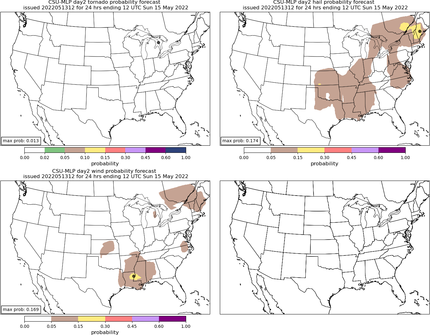
A strong cold front is set to move across New England late Monday. Combination of surface temperatures into the upper 70's to lower 80's and dewpoints into the lower 60's will yield modest levels of instability (MLCAPE ~1000 J/KG) with poor lapse rates limiting further instability. Aloft, a strong shortwave trough rotates across the region resulting in ample wind shear with 700mb winds approaching 40 knots and 500mb winds approaching 60 knots.
As the cold front encounters the warm and humid airmass, a line of rain and thunderstorms will likely form across NY/PA and propagate southeast into New England. Strong shear will help aid in convection organized. While instability will wane with southeastward extent due to marine flow, strong dynamics aloft may help compensate and allow for the line to continue progressing towards the coast, albeit weakening.
Given modest CAPE and strong wind shear there will be localized threat for damaging wind gusts.
By no means a BIG severe threat but something to be excited over, especially knowing the REAL stuff isn't far away.
-
2
-
-
18 minutes ago, Typhoon Tip said:
Yeah...and in all seriousness, we do have to keep an eye on it a heat synoptic enthusiasts. For that, and perhaps risk assessing. Through the end of the month. (Mem Day weekend have pingers and 40 F rain will happen if it 1,000 F book ending it, come hell or high water)
The PNA is inconsistently negative, and that is precarious for an eventual Sonoran or SW heat release into the downstream flow.
This is interesting to me ... both the GGEM and Euro oper's show a 570 non hydrostatic closed anticyclonic node up there over Alaska. That -EPO incarnate. Noormally by now, that should not mean much? The seasonal R-wave structures break down toward summer entropy ..etc. But there is an insidiously hidden faster than normal velocity of geostrophic wind over the total planetary scaled integral. It's forcing those synoptic super-structures to lag perhaps longer than normal. So a -EPO up there, crashing heights down the Great Basin couplet, sends heights up in the OV...viola! that drags the SW heat out and there we go. The GGEM flat out does that D8-10 ( 00z oper.).. It's ensemble mean is less though. But the oper run isn't impossible - it's showing what a slightly more amplified variant is capable of.
That could still do all that despite the modestly -PNA/ +AO/NAO.
I don't know if there would be meteorological data to back this up (it could certainly be proven/disproven easily but can't do it right now) but I wonder if we see our higher end heat events when the source region is more southern Plains as opposed to desert Southwest. I only wonder this b/c you would think based on trajectory it would be much easier to eject in here from the southern Plains as opposed to from the Southwest for a number of reasons and my guess is one reason would be you have a shorter distance to cross so less time for the airmass to be compromised?
-
The continued signal though for big heat in the South is pretty crazy...looks like another stretch of record heat across many areas. Could see high's 105-110 across parts of Texas and Oklahoma.
-
18 minutes ago, Typhoon Tip said:
Yeah..just wrote a tl;dr to Brain about the GFS next weekend. It may be right in principle, purely based on our sore-butt climate. Lol. But the way it is going about doing that is not likely correct, imho. It really appears to generate heat lows and then 'thinks' its own creation is a cold front after the fact. That would all by definition be an artifact - perhaps less true, but we'll see.
The potential is certainly there, especially if we see such a trough dig into the West like what is being advertised. But even if the signal gets muted a little bit we'd still be looking at some big heat given how anomalous the look is now
-
The challenge for next weekend is you have that vortex across eastern Canada and southern tip of Greenland with multiple pieces of energy rounding this. Depending on strength and proximity, this could keep much of our region in a northwesterly flow and halt the northward progression of the warm front. Maybe a scenario where NYC is 95-98 while we are in the 70's.
-
Some pretty big differences though between the GFS/Euro for next weekend. We could easily end up near/slightly below-average as we could well above-average with record daily heat possible.
-
Hope remains alive

-
 1
1
-
-
4 minutes ago, yoda said:
BULLETIN - EAS ACTIVATION REQUESTED
Severe Thunderstorm Warning
National Weather Service Twin Cities/Chanhassen MN
616 PM CDT Thu May 12 2022

The National Weather Service in the Twin Cities has issued a

* Severe Thunderstorm Warning for...
  Pope County in west central Minnesota...
  Chippewa County in west central Minnesota...
  Stevens County in west central Minnesota...
  Swift County in west central Minnesota...
  Northwestern Kandiyohi County in central Minnesota...

* Until 700 PM CDT.

* At 615 PM CDT, severe thunderstorms were located along a line
  extending from near Milbank to 6 miles southwest of Appleton to
  near Hanley Falls, moving northeast at 85 mph.

  THESE ARE DESTRUCTIVE STORMS FOR APPLETON AND BENSON.

  HAZARD...100 mph wind gusts.

  SOURCE...Radar indicated. At 608 PM CDT, Madison airport reported
           a gust of 94 mph.

  IMPACT...You are in a life-threatening situation. Flying debris
           may be deadly to those caught without shelter. Mobile
           homes will be destroyed. Expect considerable damage to
           homes and businesses. Expect extensive tree damage and
           power outages.

* Severe thunderstorms will be near...
  Granite Falls and Appleton around 620 PM CDT.
  Maynard and Lake Oliver around 625 PM CDT.
  Clara City around 630 PM CDT.
  Hancock and Raymond around 635 PM CDT.
  Kerkhoven, Chokio and Cyrus around 640 PM CDT.

PRECAUTIONARY/PREPAREDNESS ACTIONS...

This is an EXTREMELY DANGEROUS SITUATION with tornado like wind
speeds expected. Mobile homes and high profile vehicles are
especially susceptible to winds of this magnitude and may be
overturned. For your protection move to an interior room on the
lowest floor of a building. These storms have the potential to cause
serious injury and significant property damage.

A Tornado Watch remains in effect until midnight CDT for central and
west central Minnesota.

&&

LAT...LON 4575 9625 4576 9514 4533 9512 4489 9525
      4489 9548 4477 9549 4477 9551 4480 9551
      4491 9568 4491 9572 4493 9573 4495 9580
      4516 9604 4518 9610 4541 9612 4542 9625
TIME...MOT...LOC 2315Z 213DEG 74KT 4517 9662 4514 9613 4471 9566

THUNDERSTORM DAMAGE THREAT...DESTRUCTIVE
HAIL THREAT...RADAR INDICATED
MAX HAIL SIZE...<.75 IN
WIND THREAT...OBSERVED
MAX WIND GUST...100 MPH
Holy shit
-
Nothing like watching hockey outside

-
2 hours ago, CoastalWx said:
Again how did we arrive at that number?
I’m always curious on that myself…especially with these higher magnitude numbers. I’d also be really curious to know how many times per event you see a hail size/wind gust near what’s projected
-
Now this is a severe thunderstorm watch. Hopefully we can muster up something similar in a few weeks

-
3
-
1
-
-
Severe threat possible Monday!!!

-
1
-
1
-
-
6 minutes ago, Lava Rock said:
I was watching the Derby last wknd and jokingly said aloud, "100,000 on Rich Strike". Couldn't believe it when he won.
Didn't some kid actually pick him to win?
4 minutes ago, RUNNAWAYICEBERG said:Wasted $1k. Just flush it down the toilet instead. So many better bets to be had even at long odds.
Agreed there. I don't do much betting on DraftKings but when I do I usually go for long-ish hit stuff. I always bet $60 though haha and look for payouts that are $500+ but I don't do this very often. But there are certainly plenty of bets you can do which are low cost high reward if you look hard/close.

Monday, May 16, 2022 Convective Potential
in New England
Posted
Yes I would anticipate so