

calculus1
-
Posts
5,076 -
Joined
-
Last visited
Content Type
Profiles
Blogs
Forums
American Weather
Media Demo
Store
Gallery
Posts posted by calculus1
-
-
-
1 hour ago, Tigerchick224 said:
Hi! Not sure where to put this, so feel free to remove if necessary.
I am currently a second grade teacher and have been the past twelve years and I can say I am no longer happy. Weather has always been a passion of mine, and the older I get and the less time I have left, the more I want to go for it.
However, math was always a weak spot for me. I noticed with some of the programs I am looking at, a lot of Calculus is necessary. I haven’t taken that type of math in 13 years.
For meteorologists on the board, do your have any useful tips or suggestions on how to do well on the math that comes with a weather degree? Thank you in advance.I am not a meteorologist, but I’ve got a pretty good background in mathematics. Having taught the calculus sequence for many years, I can tell you that most students do not find the concepts of calculus that difficult. However, the algebra required to manipulate expressions so that the calculus can be applied is where they get tripped up. My suggestion: really brush up on your algebra skills. Practice, practice, practice with your ability to factor complex polynomial, rational, and transcendental expressions. If you can do that well, you won’t have much difficulty with taking derivatives and integrals.
Best wishes with wherever you decide to pursue your degree in meteorology. Don’t be afraid to talk to your professors and seek their help outside of class. Most will actually appreciate that you are interested in learning and are willing to apply yourself.
-
 2
2
-
-
1 hour ago, EarlGrey said:
from WRAL.
The wedge is real with a tight gradient.
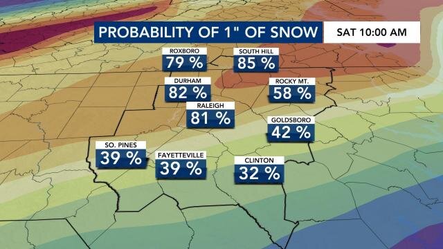
Here they go again with their meaningless precision probabilities…
32%….

-
1
-
 2
2
-
-
Yeah, really like where the NAM is going at the end of the run. But, I can’t decide if that’s a good or bad thing, because it’s the 84-hour NAM. Virtually no wintry precipitation for anyone with the stalled out front unless you are on the immediate coastline. But, it gets cranking near the end and possibilities abound…
-
4
-
-
15 minutes ago, PackGrad05 said:
I'd be weary of the NE trend in this situation. We need to see the precipitation blossom as the low rides the coast, and not wait until it's in NE NC/SE VA to do it.
If it happened a lot, then I might be weary of it. But perhaps we should be leery or even wary of it? Uncertain.

-
1
-
5
-
-
LOL at @franklin NCwx in the main thread saying we need this thing more amped for a decent storm.
Sent from my moto e5 supra using Tapatalk-
2
-
-
17 minutes ago, WxKnurd said:
Can’t tell what’s blowing snow and what’s the light snow and diamond dust that’s been falling pretty much all morning. It would SLOWLY be adding up if not for the wind. Temp has been holding steady at 19 even with the sun peaking through and it being past 10 am now.
Same problem here in Black Mountain. The wind is fierce! I think most of the snow is just blowing, as most of the snow showers appear confined to the border counties according to radar, but I’m not positive. Visibility is less than a tenth of a mile right now. Crazy.
-
1
-
-
Incredibly windy here in Black Mountain this morning. The windows were rattling at various times over night. Want to get back out and go sledding again, but it looks bitterly cold out there.
It snowed quite a bit more last night, but I can’t tell for certain how much because the wind has once again blown it all around. So, we have somewhere between 10 and 12 inches of snowfall here for a final count. Awesomeness!
-
3
-
-
Good snowfall still coming down here in Black Mountain. We’re around 10 inches.
-
3
-
-
5 minutes ago, avianman said:
Moderate snow falling again in Hickory. Large flakes.
So, what’s it looking like on the ground now? Still around 5 inches total? @avianman
-
2 minutes ago, sarcean said:
Black Mountain a little higher up has been getting quarter sized flakes for well over an hour now. No evidence of the few times I have been outside as it all had been covered.
completely dumping right now
Yeah, it was snowing great while we were sledding, which made it difficult to sled. Right now, the visibility is really low, though. So, it’s fun to watch it fall back from the warmth of the house. Back down to 28 degrees.
29 was the high.
-
Just got back in from a couple hours of sledding with the family. It was great, except that the wind is so fierce it would blow in your face. Also, it’s such a fine powder, it took a while to get a good track laid. The tubes worked better than the traditional plastic sleds.
It’s impossible to know how much we have now, but it is pouring snow at the moment. Most areas in the yard measure between 8 and 9, but that was beaten down by sleet for a few hours, so it may be actually closer to 10 or so. Dunno.
Lots of fun here!
-
2
-
-
Oh, and we’re up to around 8 total inches of mostly snow and a little sleet.
-
1
-
-
Still sleeting here in Black Mountain. Temp has risen to 28 too. It was 23 about two hours ago. Really hoping it switches back to snow soon.
-
Back to heavy sleet here now in Black Mountain again.
-
Big puffy cotton balls coming down now. Just a little bit of sleet mixed in. Biggest flakes so far today.
-
5
-
-
Solid sleet now in Black Mountain. Pingers!!
-
2 minutes ago, BhamParker said:
What radar station do you guys use for this area on RadarScope? I’m using Greenville Spartanburg, but nothing seems to be really good. The returns have hardly matched what I’m seeing from the sky
The mountains block the radar beams. There’s not a good radar to properly analyze what is happening over the mountains.
-
3
-
-
Changing over to a mix of snow, sleet, and graupel here in Black Mountain.
-
2 minutes ago, AirNelson39 said:
Over to mostly sleet in southern Caldwell. Pretty insane with 23 degrees and 10-20mph winds.

Is that the Lake Hickory bridge on US 321?
-
1
-
-
Still hard to measure because of the wind. I measured anywhere from 7 to 9 inches in the grass out in the open. I’m gonna go with a conservative 7.5 inches, but it might be more. Still snowing steadily, though not as heavily as it was just a bit ago.
-
1
-
-
Yeah, the dry slot is failing to transition further east, for now. Radar looks great.
-
1
-
-
All snow here in Black Mountain still. Hard to get a good measurement because of how windy it is here and my in laws have no big trees around them. The wind just sweeps it all around. The deck looks like only 2 inches on the railing, therefore.
Out in the grass, I took four different measurements: two sixes and two sevens. Average of 6.5. Drop out another half inch for grass inflation, and we easily have 6 inches total here!
Took a long walk out and about Owen High School. If you know the area, it is brutal on top of the hill near the Presbyterian Children’s Home. The wind sweeps across the road and just flings the snow in your face.
I love it, though! This is awesome!
Glad to hear we got about 5.5 inches back in Hickory before it has since changed to sleet. That’s amazing for that area.
-
2
-
-
11 minutes ago, avianman said:
About 3.5 inches with heavy snow falling and blowing in NW Hickory.
Thanks so much, @avianman. We made the decision to ride out the storm in Black Mountain, so I’m curious what conditions are back home. It’s windy up here with steady snow.
Take some good measurements for me. I’m in NW Hickory too, so I’ll use your backyard totals for my stats since I can’t take them myself.
3.5 already is great! Hopefully, you can keep that transition line to your south and east.
-
2
-

January 20-22 “bring the mojo” winter storm threat
in Southeastern States
Posted
https://twitter.com/webberweather/status/1483813679661563907?s=20