

Floydbuster
-
Posts
3,132 -
Joined
-
Last visited
Content Type
Profiles
Blogs
Forums
American Weather
Media Demo
Store
Gallery
Everything posted by Floydbuster
-
In the last 20 years, we've had Iris 2001 (Retired, replaced with Ingrid) Isidore 2002 (Retired, replaced with Ike) Isabel 2003 (Retired, replaced with Ida) Ivan 2004 (Retired, replaced with Igor) Ike 2008 (Retired, replaced with Isaias) Igor 2010 (Retired, replaced with Ian) Irene 2011 (Retired, replaced with Irma) Ingrid 2013 (Retired, replaced with Imelda) Irma 2017 (Retired, replaced with Idalia) Ida 2021 (Likely retired) Ten "I" storms retired in 20 years. To be honest, I was a little surprised about "Igor" and "Ingrid" being retired, and Isaac is the only remaining original "I" name from the rotating lists created 40 years ago.
-
-
-
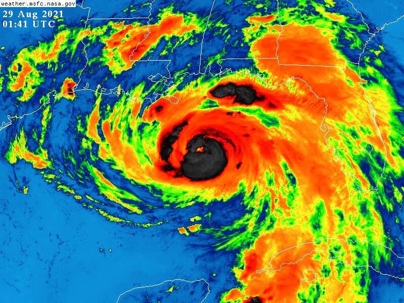
I cannot believe the way Ida has stayed together. It's been over land for like...9 hours and is still a major hurricane!!
-
Any videos of Cat 4 gusts?
-
Grand Isle is gonna be a mess. Those winds are insane in that inner eyewall.
-
Landfall Video Update for anyone interested https://www.youtube.com/watch?v=lp0sefV_3X0
-
That seems too low considering the winds we are seeing in Grand Isle.
-
New Video Update on Ida https://www.youtube.com/watch?v=Wn93ba2UPJo
-
HurricaneTrack.com's webcams show significant surge occuring already near Waveland.
-
Sorry for sharing an incorrect tweet. My apologies.
-
HOLY COW.
-
3am Bulletin Update on Hurricane Ida, now a Cat 4https://www.youtube.com/watch?v=Cbgj5wRtxWs
-
Those hurricane winds are expanding too, not good for New Orleans or for storm surge.
-
Someone asked yesterday why these storms as of late (Michael, Laura, now Ida) seem to deepen towards landfall whereas so many in the past weakened. The answer seems to be storms that wait until the last day to get their act together. Had Ida strengthened into a Cat 4 by Cuba, no way would it have maintained it for a straight 48 hrs without inner core changes and fluctuations.
-
Holy cow. Stewart could probably pull the Cat 4 trigger if he wanted.
-
116 kts FL still outside the main NE Eyewall.
-
-
Yeah it's possible that the pressure keeps lowering and then the winds end up catching up to 100-120 kts.
-
I was just gonna say. I've been kinda blah about Ida's appearance all evening but I think this may finally be the strengthening trend we've been anticipating. Ida is also crossing over the loop current heat as we speak.
-
Man it sure looks like Ida is gonna head more towards Southeast Louisiana than Central....and they will definitely be in the right-front quad.
-
Yeah. We have to remember, most of Hurricane Laura's surge was over uninhabited wildlife preserve areas. This will likely be different.
-
I think the NHC is gonna have to adjust the track east at 5pm. I don't think landfall will be anywhere west of Morgan City/Houma.
-
Even as "recent" as Andrew in 1992, we didn't have special updates or fixes from the NHC. (If we did they were never archived)


