

Floydbuster
-
Posts
3,132 -
Joined
-
Last visited
Content Type
Profiles
Blogs
Forums
American Weather
Media Demo
Store
Gallery
Everything posted by Floydbuster
-
Yeah. With the snowdrifts as high as they are already, even 7 inches is nothing to scoff at, but if it goes higher, it'll be great. (For weather enthusiasts)
-
How long until a WSW for Northern Ohio? Tonight?
-
Hmmm. Not bad but hoping for a few inches more. That map gives me about 6-8 inches.
-
Well I think 8-12 inches is still quite significant, especially with the plow shortages and the snowdrifts already built up from a few weeks ago.
-
If the trends continue, you'd be good in Strongsville too.
-
I'm biased because I live in Summit County. That being said, as someone wanting it to come south, the trends today are much more encouraging than 24 hrs ago.
-
Yeah I'm getting a better feeling.
-
Trending more my direction on these maps today. (I'm near Akron)
-
Atleast some south trends this morning.
-
Well with the way all the non-meteorological people are talking on social media and around the water cooler, if we don't get atleast 10+ inches, they'll say it's an over-hyped bust.
-
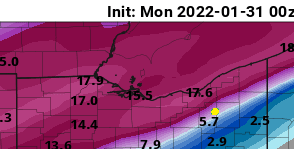
I'm stressed about those close lines. I live where the yellow dot is. I need those high numbers to move literally just 50 miles south. That's all. LOL
-
Holy cow that's alot of snow. That's 25 for Cleveland and almost 14 inches for Akron. That would be insane.
-
Those people always get buried. It's our turn again, darn it! LOL In all seriousness, the hype on FB around these parts of NE Ohio is very lopsided. The regular folks seem to be looking at local weather forecasts, and model maps like the GFS showing NE Ohio being buried. The "EURO" people are looking at trends, etc and leaning more towards a northern solution.
-
If the 18Z GFS pans out...Northern Ohio will be buried again from Toledo to Chardon.
-
Six hours ago I was hyped up for Cleveland/Akron to get 10-25 inches of snow. What the hell happened in the last six hours?
-
Better stop this north trend crap.
-
Yeah. I want that heavy snow shot over Cleveland and Akron! What’s this over the lake bull crap?
-
So you’re not thinking the accumulations in Akron the models show? You seem to be saying pretty much any snow will stay over the lake.
-
Is most of that accumulation between Thursday and Saturday?
-
Yeah. I agree. I think even 10 inches would be considered "major" for those of us here in the Cleveland/Akron area. When we start getting into 20+ inches, that's insane. One of the weather forecasts my sister has on her phone shows 3-5 inches late Wed night into Thursday, and then 10-16 inches Thursday into Friday.
-
How much did you guys get in Mentor? My girlfriend is in North Royalton and she got slammed but I think we got more accumulation in Stow. I received around 18 inches in Stow.
-
Cleveland/Akron mets and peeps seem to be hyping this one up as another 15-20 inch bruiser storm. Better not disappoint!
-
Yeah, but the word of mouth on social media with my Northeast Ohio peeps is that they're expecting a massive second helping, perhaps surpassing that storm. Even the Cleveland and Akron NWS are hyping it up.
-
That would totally suck for show junkies in Northeast Ohio.
-
Yes, but like frogtown said...I'd go with a middle of the road path. Coincidentally, that would bury myself here in Akron


