

OceanStWx
-
Posts
19,758 -
Joined
-
Last visited
Content Type
Profiles
Blogs
Forums
American Weather
Media Demo
Store
Gallery
Posts posted by OceanStWx
-
-
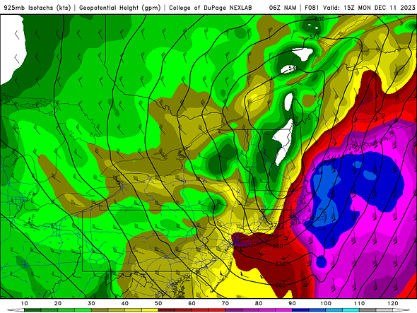
LOL
That's the wildest 925 mb wind run I've seen in a while.
-
2 minutes ago, weatherwiz said:
mid-level dry slot punching in
Yeah, it's right there with the 500 jet.
-
 1
1
-
-
8 minutes ago, powderfreak said:
Your zones SE of the mountains and on the coastal plain can’t be an easy forecast. Could be a birch flattening 5-8” warning paste job, or 1-2” of slop, with white rain. I feel like the same is true here in the valley between the ridgelines.
If places get a good quick 0.40-0.75” in 6-hours, with -1C at 925, it should snow even down low. The longevity of the event also means the highest totals will be higher up, the places that don’t have to rely on rates to accumulate more efficiently.
Places like CON really show the uncertainty. Bufkit says the NAM snows about 4.5 inches (compacts down to around 3), but for most of that time especially Sunday the snow growth zone isn't saturated. Hard to believe daytime snowfall accumulating in an environment like that.
-
1 hour ago, powderfreak said:
Ratios are not going to be close to 10:1, but another elevational paste job seems likely for most of NNE. With the CAD bringing paste to lower els in NH/ME.

I really like the look of the Euro/NAM postive snow depth change maps, which of course put it right on the razor's edge of warning for many.
-
Just now, dryslot said:
Coastal areas are the wildcard in this.
I could see a scenario where the first wave kind of warms over the air mass and the second, snowier wave struggles to accumulate if the rates aren't there.
-
1
-
-
9 minutes ago, Lava Rock said:
Local Mets don't seem very excited
Sent from my SM-G981U1 using Tapatalk
We've established that something is going to happen now, but the two part wave brings a whole bunch more uncertainty into play.
-
4
-
-
Even up here the coast seems like it's tough shape given current ensembles. There is some mean snowfall, but the 50th percentiles are all snowless along the coast suggesting some big members are dragging that mean up.
But the cluster that features a little pump up ridge ahead of the wave are the ones that are snowier.
-
 2
2
-
-
3 hours ago, eekuasepinniW said:
Could be some pretty intense aurora action tomorrow or Friday night.
Or it could be underwhelming like roughly every solar storm in the last 20 years.
Friday night looks great.
-
 1
1
-
-
On 11/28/2023 at 4:06 PM, ORH_wxman said:
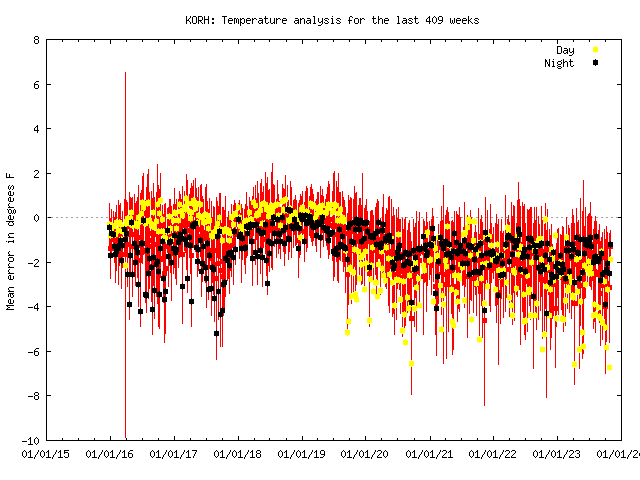
The empirical evidence for ORH running too warm is overwhelming. I’m not sure how you can look at data for more than a few minutes and conclude otherwise. Even if you do not trust MADIS, just compare sthe ORH monthly departures to other first order climate stations in SNE and you’ll see consistently that ORH runs warmer. They are also consistently warmer than just about every single mesonet site at similar elevation near them. I’ve looked at this extensively since discovering the issue.
Here’s the MADIS graph on a longer timeline. Pretty obvious step change in 2020 that also aligns with ORH’s divergence from other first order sites on monthly departure
Sometimes these biases can be legit, if there has been some kind of use change near the ASOS/AWOS. I remember several years back CON had started running warm, and we found out that they had ditched grass in favor of rocks around the ASOS to make landscaping easier. I think we ended up putting astroturf down.
-
On 11/27/2023 at 5:41 PM, CT Rain said:
@OceanStWx needs to get to work on this!
I think we can manually edit the naming convention in the system, but man it picks some random location identifiers sometimes. Like IOSN3 always defaults to 4 ESE of Rye, like just call it Isles of Shoals. And no location ever carries elevation, all that has to be added. What I don't know is if it has to be added each time, or if certain locations can be saved.
-
There's definitely a hint in the hi-res models of some latent cooling just ahead of the low center. Temps tickle down a few degrees without any CAA. Probably good news for Sunday River and the Loaf.
-
8 hours ago, Ginx snewx said:
Ooh wish we had some CAD we could pull off a 12/9/05
CAD is lacking, but a blue bomb is not out of the question. Even some valley locations are close.
Bufkit for places like LEB and HIE have some hours of isothermal paste that's like 2"/hr. Might be a little too torchy for the Monadnocks, but farther north could be a 1000-1500 ft birch bender.
-
8 hours ago, Ginx snewx said:
Instead of millions funneled to the climate research side maybe take care of the here and now.
I mean they aren't even the same budget bins, so it's not like it could be used either way. NCEI is in NESDIS and repairs come out of the NWS budget. The bigger problem is that we can't get a full budget passed, and so continuing resolutions default to previous funding levels. So even under normal inflation our budget doesn't keep up, and the first and foremost thing to pay for is manpower and keeping the lights on. So repair work gets tighter and tighter, model development work suffers, etc.
-
2
-
-
Sneaky little system Mon. Quickly developing low kind of cuts off the LLJ for GYX, but HRRR is developing a little stinger that may clip the Cape. And Downeast should rock, might even be trying to model some gravity waves in there.
-
1
-
-
6 minutes ago, CoastalWx said:
19 at 9pm at MVY

-
1
-
-
8 minutes ago, CoastalWx said:
+\- 2. Let’s get the airplane to slide off the runway with ASOS temps of 34F. Sounds reasonable.
We're one Sandy away from a regional mesonet!
-
 1
1
-
-
53 minutes ago, ORH_wxman said:
Errors theoretically should cancel out if they are random…some will be too warm and some too cold. There’s so many asos stations that we have a very good idea of larger scale temperature trends.
But a corrupted ASOS at ORH for example is a major problem if we want to analyze temperature trends at that one spot. We’ll see a spurious jump in temps starting around 2020 that isn’t real.
It's pretty comical how thin the supplies are sometimes. Like the whole radar service life extension program (SLEP). We had like two extra pedestals for the whole country, so we leapfrogged teams around the nation refurbishing. Give CAR the spare pedestal, refurbish theirs, give it to GYX, refurbish GYX's old pedestal, give it to BTV, etc.
-
10 minutes ago, WinterWolf said:
So if the climate section of NWS is almost all ASOS, then how can we even remotely trust the whole temp thing in this country..when lots of them are off? Which most of us with a brain already know anyway.
And I get it…if they are within +/- 2 degrees like you said, you don’t/or have the resources to check them. Then It’s a joke overall. Pretty Comical.
Well there are more sources than just NWS CLI sites. And even dozens of climate sites running warm or cold will be washed out by the shear number of observations (plus you have some ASOSs running warm, others running cold also washing out).
-
1 minute ago, NorEastermass128 said:
I think you’re misremembering. 11-12 was a dumpster fire.
Not if you like Morch and 50% of your seasonal snow before Thanksgiving.

-
1
-
-
31 minutes ago, Layman said:
Does current climate data come from these ASOS sites?
The global climate dataset is more complicated than just ASOS, but the climate section of the NWS website is almost all ASOS. There are a handful of climate observations that are manual obs (for instance the Gray observation is taken here at our office which has no ASOS).
-
1
-
-
14 minutes ago, weathafella said:
It’s like no one in NWS cares about important climo records at first order stations. Very disappointing.
It's not that we don't care, it's that we can only do so much. The only reason ASOS exists is for FAA flight purposes, and they don't care about temps, so the tolerance is like +/- 2 degrees. So if temps are still falling within that range the equipment is not malfunctioning and not in need of repair. With the budgets being they way they are, we definitely can't go replacing equipment that isn't in need of it. Then if an ASOS does break, it's more likely it will just be down until a replacement part arrives.
-
4
-
-
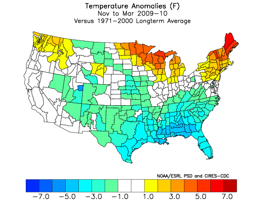
2 hours ago, tamarack said:
You had to bring up that one again. Most frustrating winter in my memory, for many reasons, but worse up north - the idea that BWI could have 7" more snow than CAR was mind-blowing. Also, CAR's temp for Jan-April must be at least one SD beyond that for any other year. That period in 2010 was 8.7° AN while 2nd mildest (2021) was 5.3° AN.
This map perfectly conveys the snowfall distribution that I had in mind doing my outlook.

The Farmington co-op averaged 104% of average for those 6 winters, but 4 of the 6 were BN with 3 at the edge of ratter territory. The 173% of 1968-69 (their snowiest of 130) skews the average.
After more than 50 years of observing for us, Dennis and his wife have now both passed. As is the story with many of our coops, I'm not sure whether they can be replaced. I certainly wouldn't expect any observations this winter.
-
5
-
-
16 minutes ago, 40/70 Benchmark said:
You don't need an exotic anomaly like that...in fact, it was so extreme that it was of a detriment to most of NE, as it wrapped milder maratime air in from the NE and also blocked some systems from coming up the coast.
Bunch of mountain men trying to hang themselves from moose antlers up in The County.
-
3
-
2
-
-
16 minutes ago, Cold Miser said:
Why do certain times of the day with modeling outputs show crazy stuff like this? What is the reasoning?
I don't think there's really a particular time of day run that leads to wild solutions, it's just the nature of a single run deterministic model. You're bound to get a wound up storm every now and then, but the reality is it's just one of 30 to 100 ensemble members.
-
2
-
1
-


December 2023
in New England
Posted
The NBM mean wind gust at RKD is 70 mph with a standard deviation range of 60-80 mph. Overnight model runs really amped the wind threat up from when I left yesterday afternoon.