

OceanStWx
-
Posts
19,758 -
Joined
-
Last visited
Content Type
Profiles
Blogs
Forums
American Weather
Media Demo
Store
Gallery
Posts posted by OceanStWx
-
-
Lost 10” of pack overnight and pulled 3.22”
Slushy river running through the backyard drainage.
-
1 hour ago, Ginx snewx said:

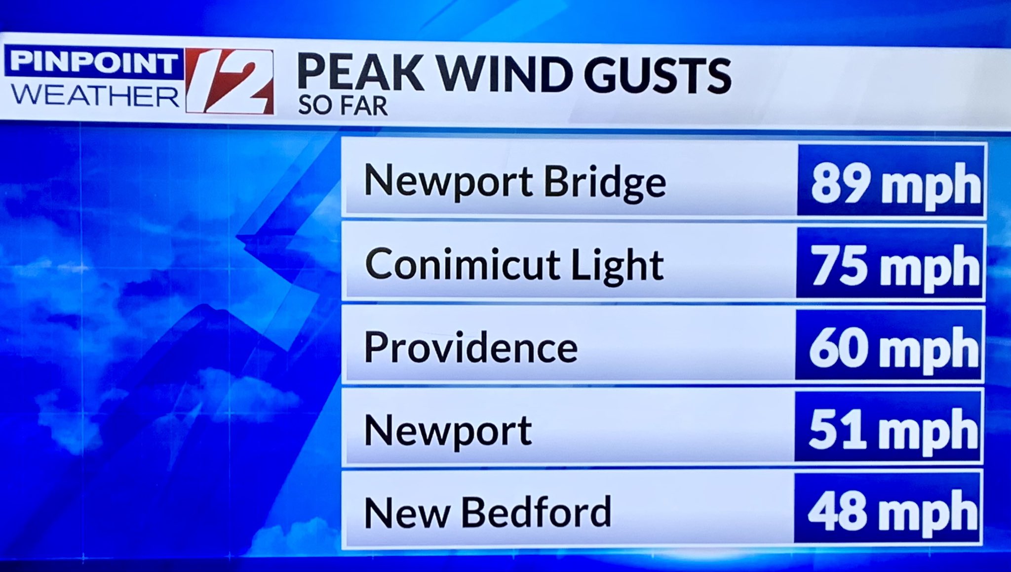
Never doubted the waters would rip. That 75 mph is a good gust for Conimicut. Must’ve funneled right up the bay.
31 minutes ago, powderfreak said:BTV gusted 69mph.
Thats solid.
It’s been flashing red light downslope signal for nearly a week. Where’s my DraftKings bet on BTV wind gust > PWM?
-
 1
1
-
-
10 minutes ago, dryslot said:
Snow to rain line progressing north, Probably another 30 mins or so before the changeover.

Maybe less than that. We're toast at the office now.
-
4 minutes ago, weatherwiz said:
1-4 AM (earliest southwest CT and then moving northeast through the early overnight).
there may actually be two separate lines...one forming now and then something that goes across southeast MA late overnight.
Too bad Kevin will be asleep for all of it.
-
 2
2
-
-
PEO gust to 63 knots. Real man stuff back in CNY.
-
Well the snow was short lived at home. But the good news is the solar panels shed 16" from the last event.
-
3
-
-
6 minutes ago, dendrite said:
28.7° +SN
Already 3”
Poundin
Don't like that. I do have you down for 6-7, but I need CON to flip otherwise I may need to upgrade.
-
6 minutes ago, Damage In Tolland said:
Nothing had this . Machine or met
The HRRR did have 38G65KT for 01z.
If I had to pick something to rip and read right now, the HRRR looks fine.
-
Quick raob check, OKX had 55 knots at 925 mb. Assuming they launched on time around 23z, that's about 5 knots lower than the RAP (which is fed into the HRRR). NAM doesn't have 23z data, but knocking it's 00z forecast down a few knots has it forecasting 925 winds about 10-15 knots too high at this hour (similarly the GFS).
Now it could just be a delay in the LLJ, but I think it's more likely the stronger winds are just more elevated than modeled.
-
2
-
-
2 minutes ago, PWMan said:
Straight to rain, 36.
I'm almost certainly going to start as snow at my place, but I have zero doubt I'll flip before my shift is up and I can get home an measure.
-
1
-
-
2 minutes ago, Damage In Tolland said:
It was 100 kt on 12/18.
-
1
-
-
3 minutes ago, Damage In Tolland said:
Over / under 57mph gusts in CT?
57 anywhere in CT? I would take the over. Up by you I just don't think it will be that high without a serious assist from convection.
-
2 minutes ago, Damage In Tolland said:
It’s pretty much the same setup just farther north
Sure, the edge of the 60 kt winds are twice the height by the time you get up to your latitude, but other than that it's the same.
-
1 minute ago, CoastalWx said:
Oh you live on LI now. Good to know.
BDL in the summer, ORH in the winter, and ISP on a sou'easter.
-
1
-
3
-
-
20 minutes ago, weatherwiz said:
I'm not totally sure I completely agree with that assessment of the LLJ. It certainly isn't as expansive as Dec 17-18 but I don't think it is weaker but that is also relative based on where you're comparing too. In that event, mixing was aided with the expansive warmer temperatures which muted the inversion. Now I get we have the snow cover and that is going to fight back the warmth a bit, but there is still a good signal we get 50's into a good part of CT on east.
At least to me, there is a much stronger signal for convection than Dec 17-18. While soundings aren't impressive in terms of mixing we have to look at the potential for convection to draw down these winds - so yes, convection or bust in terms of winds. I don't think bufkit handles situations very well where its torrential rain with wind potential. Take a look at tropical systems...if you look at bufkit profiles for tropical, you'll see bufkit subdue the wind big time when it has torrential rain falling.
Sfc instability isn't great at all, but we do get some elevated instability with TT's also pushing into the upper 40's and LI's crashing down towards the lower single digits.
We'll see.
I don't have the modeled LLJ for 12/18, but you can see the difference a bit in the EFI product.
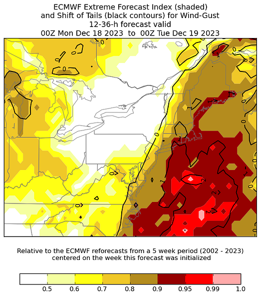
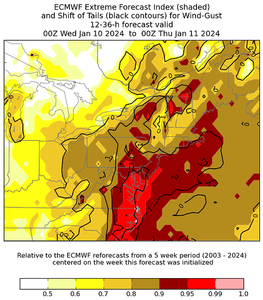
Remember this product isn't as simple as extreme = big wind, it just means unusual for this time of year.
Much bigger CAD signal for this event. Also a much bigger downslope signal.
The shift of tails (black lines, and the real indication of the higher end gusts) also are inverted for this event. Instead of values near 1 across the interior to the coast of Maine, they are all focused in the northwest downslope zones. I would be more surprised if GYX pops a 50 kt gusts than BTV.
-
1
-
 1
1
-
-
2 minutes ago, Damage In Tolland said:
You don’t listen to anything they say .. remember ?
Started as plain rain and your 60 kt gusts are going to bust. Tough day.
-
1
-
5
-
-
4 minutes ago, weatherwiz said:
Yup...it's coming.
I'm shocked wind isn't being played up more. It gets hyped up when it it will be a non-event and then not hyped up when it will be a big event.
It's essentially going to be like a 85 mile wide EF-0 ripping through the region
I'm just not as impressed as 12/18. The LLJ is weaker around here and there is plenty of snow/CAD. I'm more in the strong advisory (weak warning at the coast) camp.
-
3
-
 1
1
-
-
1 hour ago, WinterWolf said:
That doesn’t even make sense. Lol. C’mon pal, you’re just being ignorant now.
Well some people believe that if you don't observe it, did it really happen.

-
1
-
1
-
-
3 minutes ago, dendrite said:
Ditch the 10:1s
Actually may be a better event for Kuchera.
-
1
-
-
Just now, Patrick-02540 said:
Who wants to educate me? How does a snowpack limit winds from reaching the surface? Thks in advance.
Any warm near surface air is expended to melt the snowpack, keeping surface temps colder. This sets up an inversion which makes winds harder to mix down.
-
4
-
1
-
-
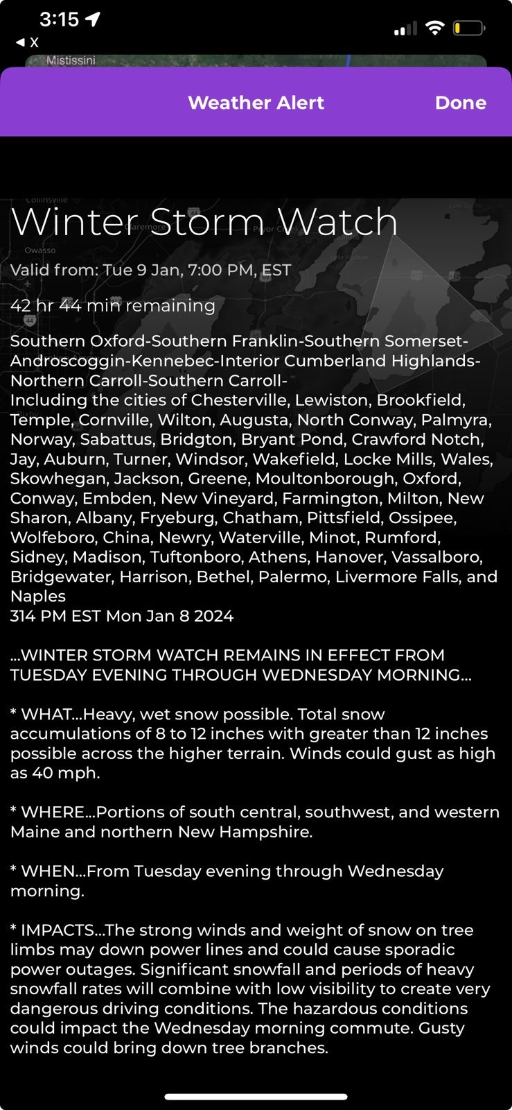
2 minutes ago, Layman said:
My brother in Wolfeboro just sent me this screenshot from 3:14pm. I'm thinking everything will be more north of there. He said he's been checking various reports all day and they're changing by the hour:
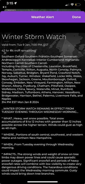
More for the higher terrain than Wolfeboro proper, but a 4-7" thump before a flip is not out of the question.
The tough part about the watch text is that this is a grouping from Carroll County up through the Maine mountains and AUG. So it's a large area and the formatter just averages the totals out to 8-12". Much of that watch will be more like 4-7" or 5-8".
-
1
-
1
-
-
1 minute ago, dryslot said:
10.5625:1, More Meaty then here.
I was 12.5:1 in the morning, dropped to 10.5:1 by 1 pm, and the final measurement 9:1.
-
5 minutes ago, wxeyeNH said:
I really don't know how much snow to expect here in SE Grafton County. Gray just has us under a Hazard Weather Outlook. No high wind advisory nor winter weather advisory. We kind of stick out with all kinds of watches around us. I'm thinking of 5-8" ? Roof loads will become an issue if we don't warm up much tomorrow and then get another storm late week
Yeah, that area of NH is a tough call right now. But none of the wind or flooding threats appear high enough for a headline right now, and snow is likely to remain advisory level so it doesn't need a watch either. So HWO is all you get.
Bufkit is all over the place for LEB too. GFS 8 inches, NAM 5, HRRR 1.5 (but the HRRR is awfully close to a blue bomb profile).
-
3 minutes ago, weatherwiz said:
I bet we end up seeing a marginal risk for svr in a later outlook. The signal for such a line is becoming more impressive. Seeing the 3km so aggressive opens my eyes b/c it's usually more poo poo. Going to be fun to see carpet bomb SVR's at 4 AM Wednesday.
I don't know if the threat is widespread enough for SPC to take notice, but CSU machine learning does have a little 5% wind tickling CT.
1/9-1/10 Now Morphing to Less-Than-Exciting Power Cutter
in New England
Posted
We’re going to need it. Locking the water table in this high with no storage room in the lakes is definitely elevating the spring flood outlook.