

OceanStWx
-
Posts
19,758 -
Joined
-
Last visited
Content Type
Profiles
Blogs
Forums
American Weather
Media Demo
Store
Gallery
Posts posted by OceanStWx
-
-
We got our 30 burger, it just happens to be at Jeffreys Ledge.
-
 2
2
-
-
4 minutes ago, WxWatcher007 said:
They were reporting blizzard conditions on my drive in and I can say it was not that bad. The roads were terrible and there were branches and wires down, but the vis was manageable. It's almost more of a fog than snow reducing vis to my eye.
-
1
-
 1
1
-
-
1 minute ago, tunafish said:
With these heavier/convective echoes moving towards us, will they be sleet/rn or flashover to snow?
I haven't seen any sleet obs so far, just 1/4sm +SN. But I wouldn't be shocked if there was some graupel in there, because it's pretty convective.
-
 1
1
-
-
1 minute ago, tunafish said:
where in ME?
Depends how many drinks you give him first.
He's about 4 miles from the office.
-
 1
1
-
-
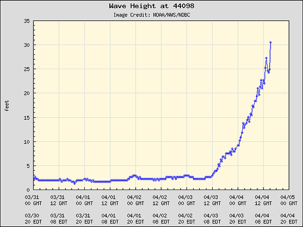
For Ginxy's eyes only...the western Maine shelf buoy is at 27 ft right now.
-
Just now, Ginx snewx said:
Would imagine water temps an issue. How about ten miles inland?
@tunafish is definitely closer to the water than me, I had another 1 or 2 inches accumulation around the same time. By the time you make it as far west as GYX you're getting into the double digit amounts.
-
Just now, weatherwiz said:
Agreed. That's why these snow maps and depth maps whatever need to be used with extreme caution. Sure they may "nail" some areas and maybe capture cutoffs and gradients but on the whole picture...they suck. Mid-level structure, evolution, lift, etc are all extremely critical at the end of the day and the snow maps don't factor that stuff in.
I am curious what PWM is at right now. I know yesterday both NAM/GFS bufkit were yielding over a foot of snow at PWM using cobb. Actually even using max temp in profile wasn't too far off from cobb.
They officially were at 4.5 with the 12z ob. Going to hard pressed to get another 8 today I think.
-
1
-
1
-
-
17 minutes ago, dendrite said:
31.2° -SN
About to ramp up

Very convective. Look at that stuff feeding in off BOS.
EEN/AFN now 1/4sm. At the very least this band should drop a quick 1-3" or 2-4" as it lifts north.
-
Just now, 40/70 Benchmark said:
Fact is, they were more accurate in totality.....perfect everywhere? No. But if you had the choice of 10:1 everywhere, Kuchera or +SDC, the latter would have yielded the most accurate forecast throughout the region. Are they too light in much of your area? Sure....but I would argue better than those idiotic 30" clown maps.
30 burgers ship sailed when the mid level lows got strung out. You need a well organized secondary AND a stall/loop, and we just didn't have that here.
-
2
-
-
Just now, 40/70 Benchmark said:
Yea, in a marginal situation, its the path of least regret.
I think they do well for situations where the entire column is marginal with those 32-34 surface temps. Locally the temps stayed around 32-34 but it was a pure snow sounding above that.
-
1 minute ago, 40/70 Benchmark said:
Positive Depth Change was largely accurate AWT.
Like many products, good in some areas, not in others. It was terrible around here, with forecasts of 2-3" but we're easily 6+ OTG away from the coast even with compaction.
-
2
-
-
3 minutes ago, NW_of_GYX said:
9” Bridgton just got to SR maybe 6”. This is gonna bust low here. Not snowing here currently.
I'm never going to jump on anyone for coming up with a soundly reasoned forecast, as long as the headlines are messaging the right thing (i.e. heavy snow and power outages).
If I had total control over the snow forecast yesterday I probably would've hedged closer to a foot rather than the 18. Like I mentioned with Will last evening, it seemed to evolve into more of a WAA snow, and it's hard to do more than a foot on pure WAA.
We'll see how well the dry slot can fill in today. There are hints of moisture aloft moving back in, and cloud tops are cooling a little bit again, but I don't think we have another double digit period of snow.
-
2
-
-
13 minutes ago, 40/70 Benchmark said:
Well, at least you gained a few tenths?

-
On to the genny around 4:30 am. Woke up to 5.3" of sticky snow (~7:1).
-
1
-
-
5 minutes ago, Arnold214 said:
I've got just about an inch in me. already feeling it a bit.

-
2
-
1
-
-
2 hours ago, dryslot said:
They just toned it down a bit, But not a lot.

Something broke with the scripts today and it nuked our actual forecast when the probabilities ran, so check it now for the actual current forecast. Not much different but a little beefier at the coast.
-
2
-
-
3 minutes ago, weatherwiz said:
will you be pulling the trigger on any blizzard warnings?
Nah. There was plenty of discussion, but overall we haven't really observed blizzards without it also being really cold, and that's just not in the forecast right now. Do I think there's a path to 20s and 1/4sm? Yes. But I'm not on the likely side at the moment.
-
1
-
1
-
-
35 minutes ago, DomNH said:
My gut still says crud but there's definitely an avenue to warning snow if everything breaks right and it pounds 1-2'' an hour from midnight to 6 am. Hate the H7 low in NY State though - to me that screams showery banded radar and that ain't going to cut it.
12 minutes ago, ORH_wxman said:The H7 warm front lifts north relatively quickly once it gets established over SNE. Some of the better runs yesterday we’re trying to stall it for a few hours which is how you get 20-burgers there but that seems unlikely now as it doesn’t slow down until near S ME/NH border. But yeah, if you can flash to parachutes by 03-04z, then you’ll have a path to warning criteria snow.
That's the biggest difference I see between yesterday and today. There was a nice H7 low over SNE on yesterday's runs, but today it just kind of looks baggy or develops really late Thursday where it's almost over NH. In that sense it is almost purely WAA driven, which gives me more of a SWFE vibe of capping things at 10ish outside of the mountains.
-
9
-
-
2 minutes ago, Ginx snewx said:
Asking again, any insight into new Rapid Refresh @OceanStWx
.thumb.png.778745b741bcef208a3674045fe14a27.png)
Honestly I don't know much about the known biases, but I would hazard a guess that they'll be similar in nature to the HRRR (since they are both RAP based).
-
2
-
1
-
-
9 minutes ago, dendrite said:
Are we talking the Mar snow event? I gusted big in that one with downslope assist. 50+
8 minutes ago, CoastalWx said:Yep. A big bag of WTF in that one.
Yeah, when the reports started coming in of a possible microburst...
But we did dig into the mesonets nearby and you could see the localized strong gusts. IIRC the inversion height was perfect for ranges like the Ossipees.
-
1 hour ago, Bryan63 said:
Must be pretty cold aloft, have sleet falling. Currently 43.
It's more that it is dry aloft in the mid levels. Wet bulb cooling the column is doing the bulk of the work there even with torchy surface temps.
33 minutes ago, dendrite said:I’m going to guess soil temps are factored into those depth maps. 4”/8” here is 40F and I tend to run cool locally. So the model probably isn’t liking snow falling onto 40-50F soils.
Surprised there haven't been a ton of AFDs crapping on the event because of warm ground.
29 minutes ago, CoastalWx said:Might get interesting there on the west side of the ridge. Maybe we can get a 2017 blowdown in Moultonboro.
That was a great WTF event.
-
Just now, CoastalWx said:
I feel like the last two years the output has been over the top. Maybe it highlights the hot spots.
That's what we've found for the QPF side of the HREF. Picks out the max values well, but the areal extent is usually too large.
-
One thing I keep seeing on Bufkit forecast soundings is that the first 10-12 or so inches have deep saturation through the DGZ, but the next 6-10 the DGZ dries out. I would be pretty wary of that additional snow unless that profile changes significantly on these 12z runs.
-
2
-
2
-
-
30 minutes ago, CoastalWx said:
When is that model not wild.
LOL at the entire GYX CWA having 90% chance of 12" in 24 hrs from 00z Thu to 00z Fri.
-
1
-

.png.65b030e6496907b83a5da7f51639d115.png)
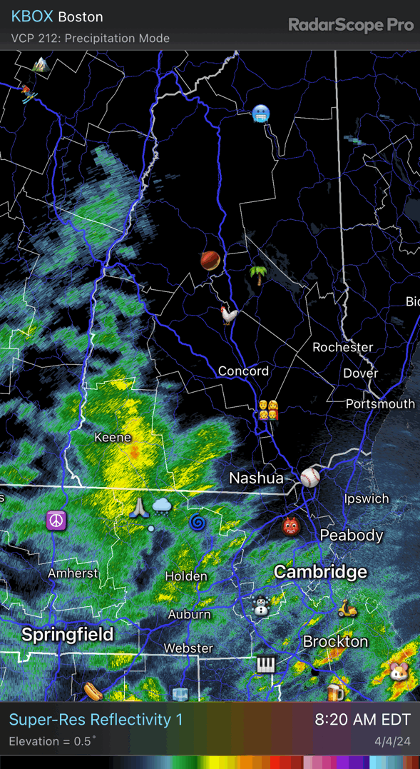
Significant Miller B Nor'easter Apr 3rd-4th OBS
in New England
Posted
WV sure looks like it's going to try and saturate into a deformation band. May have a little dry air issue near here, but overall it should keep snowing into the early afternoon.