

OceanStWx
-
Posts
20,131 -
Joined
-
Last visited
Content Type
Profiles
Blogs
Forums
American Weather
Media Demo
Store
Gallery
Posts posted by OceanStWx
-
-
3 minutes ago, tunafish said:
Ha, the 0.1" was your forecast or what you had in Portland? Or my 0.01" liquid?
Oh my backyard snowfall ob.
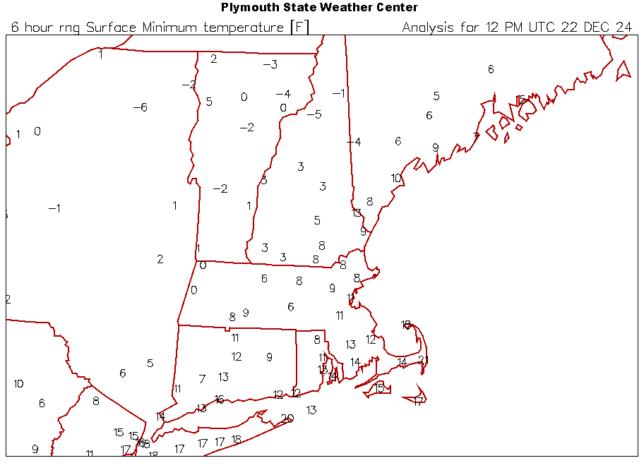
Bit of an overperformer in the north of the CWA though. A few more 6s on the board than I thought in that northern half of our area.
-
 2
2
-
-
10 minutes ago, tunafish said:
Big ole T
Almost gave you shit on the phone because I had that whopping 0.1"
-
 2
2
-
-
8 hours ago, powderfreak said:
Flakes just went small and steady. Synoptic flakes. Sounds like a low hiss outside as it falls.
Dogs back was coated quickly but not by fluff, this is more QPF 8-10:1 type stuff all the sudden.
Oh man, every weenie on this board can hear this exact sound in their head. Perfect description.
I'm not sure I can count it as a Christmas miracle yet (0.1" at 7 am) but it sure isn't a Grinch.
-
3
-
-
6 minutes ago, dendrite said:
17.8/-1.6 today
Cold, but nothing out of the ordinary for a cold winter day. I normally expect a good 10 days like this each winter.
Solid guess. CON averages 8 days with a average temp of 8 degrees or less each winter.
-
1
-
-
1 minute ago, tamarack said:
Two days ago, the Rt 2 corridor was looking at 2-3"; now that's doubled. 4-5" of 15-20 to 1 fluff would be very nice, just right to pack into the remaining ruts from the 2" RA on 12/11-12.
I wouldn't call the lift strong be any means, but the DGZ or near-DGZ is deep (which helps because the core of the DGZ is quite high in the atmosphere despite the surface air mass).
-
2
-
-
1 hour ago, powderfreak said:
I can feel people’s excitement lol.
I like 4-8” personally.
Scooter is sitting down with his kids tonight and explaining that there are snow starved children in northern New England that need the snow more than they do.
-
15
-
-
27 minutes ago, das said:
This conversation got me curious and looking around. There is a ton of peer-reviewed research on the cloud physics of snowflake generation, on decent transformations like riming and even the metamorphosis of snow ice crystals in snowpack on the ground but very, very little about wind-affected transformations as it falls. I only found one hit in the intro of one paper but it was a minimal reference:
"Snowflakes falling on the Earth's surface have a mono-crystalline, idiomorphic form (dendrite, for example) or polycrystalline elements with crystals ranging in sizes from 0.1-0.4 mm [1] at very low air temperatures (-50°C - -70°C) to several millimetres at air temperature around 0°C. Depending on the weather conditions (air temperature, moisture, wind velocity) the snowpack is formed under windless conditions from lamellar snowflakes with an initial snow density of 10-80 kgm -3 and idiomorphic contours, or from snowflake 0.2-0.3mm sized fragments formed under windy conditions with a density of about 200- 300 kgm -3."
Guseva-Lozinski, E. (1999). Transformation of the snow crystal to a particle of ice. In: Hutter, K., Wang, Y., Beer, H. (eds) Advances in Cold-Region Thermal Engineering and Sciences. Lecture Notes in Physics, vol 533. Springer, Berlin, Heidelberg. https://doi.org/10.1007/BFb0104196
Seems like an interesting topic for an enterprising doctoral candidate.
I've also always tended to think about it in terms of aggregates. It's pretty rare to have pure dendrites falling without some clumping, sticking, interlocking, etc. The wind breaks those aggregates apart. But the aggregates are forming down here, not up in the DGZ.
-
2
-
-
On 12/19/2024 at 8:28 PM, ORH_wxman said:
@OceanStWx talks about that game since he went to it. It was so cold the beers were freezing in the stands if you didn’t keep drinking them.
I've been to two classic winter Titans games. The 2004 coldest Pats game, top 20 coldest NFL game AND the 2009 59-0 October snow game.
But yes, too cold run a tap line from a keg so all beer was served out of bottles/cans. The head on the beer would freeze between sips, so you would have to poke your finger through the get the next gulp.
-
3
-
-
On 12/22/2024 at 7:15 AM, dendrite said:
Congrats everyone on higher heating costs
And DAW has been consistently 5F too warm all night. @OceanStWx can we just unplug the ASOS so Pope can’t use it?
I wish I actually had more info from the techs on this. It's been nearly daily that AOMC is calling us to let us know there have been failures on some sensors or another.
-
7 minutes ago, alex said:
Was having the same thought here. 38/28, forecast high was 34 so quite a bit warmer
Unfortunately our primary driver of temps was not advection but latent cooling. Always a risky proposition. Forcing got weaker, precip intensity is lower, less metling/cooling at the surface.
-
6 minutes ago, dendrite said:
I would’ve lost it


-
 1
1
-
-
2 minutes ago, CoastalWx said:
It's the kind of situation where being in the finger of fun (the band to the north that streaks out well ahead to the northeast from fronto) is usually the best place to be, but the narrower band sometimes may come down hard, albeit brief.
That's the real limiting factor here. It's moving so fast that you only have a few hours to accumulate. Hard to pull off much more than a sneaky advisory when that happens.
-
1 minute ago, mahk_webstah said:
Thank you. You are kind to jump in here. I assume it will be mostly snow, and I hope some combination of moderate band and good snow growth gets me north of 2" Seems possible.
It's definitely possible. These kinds of lateral quasi-stationary bands can surprise just because the forcing will be narrow but persistent.
-
1
-
-
10 minutes ago, mahk_webstah said:
This would be a very weird way to get 1-3 tomorrow night:
Rain and snow before 3am, then snow likely between 3am and 4am, then a chance of rain after 4am. Low around 31. Calm wind becoming west around 5 mph after midnight. Chance of precipitation is 100%. New snow accumulation of 1 to 3 inches possible.
It's a good example of the absolutely insane way the computer tries to put our forecast to text (remember I can't control what the P&C says beyond drawing the forecast).
You're forecast is roughly 1.4 inches, so it reads that as 1-3 inches even though 3 inches is unlikely.
It also says rain and snow before 3 am, when the predominate weather during that period is slight chance of rain and definite snow. Sure rain and snow is technically correct, but one of those precip types is more likely than the other.
-
2
-
 1
1
-
-
2 minutes ago, CoastalWx said:
Winter is 6 weeks long and spring is getting warmer. Embrace CC.
I've embraced it so hard that we're doing a week and a half in Florida this February. Only need to survive ~ 5 weeks of winter now.
-
2
-
-
39 minutes ago, dendrite said:
Never a good sign when this is bumped in late December

-
5
-
-
9 minutes ago, CoastalWx said:
I'm kidding, but can't help the Lucy feeling here.
We'll forever be trying to kick the 2015 football.
-
3 minutes ago, CoastalWx said:
We pull the plug
I'll gladly pull the snow stake out with the Christmas lights in a couple weeks.
-
10 minutes ago, Snowcrazed71 said:
So are we writing off this winter too now? I know it seems like it's a rerun of last winter in some respects. But we do still have January, February and even March.
It's a broken record in here. Something's got to give. We'll see if it's this season
I mean it may be a sad look to a once promising pattern, but we do this same song and dance every season. We've "wasted" December, when a place like ORH only averages about 10" through this date and has 7.5" on the season. The season could still end up just fine.
-
2
-
1
-
-
24 minutes ago, weatherwiz said:
I don't know how much, if any, resources this eats up but why is a NAM MOS run? 99% of the time it's a piece of junk and laughable.
Can't have too much life left. NBM MOS will replace it and the GFS MOS sooner rather than later.
-
17 minutes ago, RUNNAWAYICEBERG said:
Too many models ran too many times per day adds to the inconsistency. It takes a higher degree of skill thesedays to be able to weed through all the noise.
There's something to be said for the ECMWF style of modeling. They have one, very good model and then they just adjust it from there to suit their needs. You get 4x daily deterministic, you get an ensemble, you get an extended run.
They aren't wasting resources running a GFS, NAM, nested NAM, HRRR, SREF, CFS, etc.
Now the trick is creating a very good model to start with.
-
2
-
-
3 minutes ago, ORH_wxman said:
06z euro looks more like GFS. Clipper type system but you’re pretty close to redeveloping that for something bigger.
We need to trend this back toward digging the initial shortwave deeper and that’s how you get a higher end system
Most of the ensemble members are still pretty meh, but the snowiest ones are definitely the more amplified patterns.
-
3
-
-
14 hours ago, MaineJayhawk said:
Maybe they're not ready?
That was my thought when the power went out last night. I had just texted the NAM LLJ to Scooter and Ryan and the neighborhood went total blackout.
-
 1
1
-
-
Let's go Wiz

-
1
-
Region Wide Christmas Eve Clipper Potential
in New England
Posted
Very nice aggregates. Not shattered.