

OceanStWx
-
Posts
20,134 -
Joined
-
Last visited
Content Type
Profiles
Blogs
Forums
American Weather
Media Demo
Store
Gallery
Posts posted by OceanStWx
-
-
13 minutes ago, Allsnow said:
Pain

If you look closely at the end of the run you can see Scooter walking off into Cape Cod Bay.
-
 7
7
-
-
30 minutes ago, mahk_webstah said:
Look, obviously I don't really know anything. I just feel like things are jumping around on the models for a reason. I also ask:
1. Does strong confluence/blocking tend to over or under-perform?
2. Do strong vorts tend to over or under-perform?
Plenty of time to trend 1/6-7 and 1/10-12 even though the 1st one won't get up here, it might trend to get a chunk of SNE with accumulating/plowable. We've seen that a million times, and this is where Kevin is right.
I implore all to not succumb to misery just yet.
Bigger issue with 1/6 is that we need big changes to score. It's been at least 2 days of a consistent look that is not particularly favorable for New England. While day 5 is still day 5, we are running out of time for a big move.
-
 1
1
-
 1
1
-
-
27 minutes ago, ORH_wxman said:
Only way for SNE to see decent snow from the 1/6-7 threat is for a partial phase with TPV. If we can phase one of the spokes of energy then maybe it had a shot but we haven’t really seen those solutions…a couple runs have come close but nothing that leaves you waiting on the edge of your seat for next model run.
I'll give Kevin credit, a fully 2 out of 100 ensemble members bring advisory snow to ORH. So he's got that going for him, which is nice.
-
3
-
-
2 minutes ago, CoastalWx said:
It’s over Johnny.
-
2
-
-
7 minutes ago, dendrite said:
Can’t wait to see the 00z run have a 1040 high over us at the same valid time
Starting to get excited?
-
2
-
-
1 hour ago, dendrite said:
Are they there yet? Not looking great at noon.
He did head there today, but I do not know the status of the cleaning yet. 2 pm and it's still running warm.
-
46 minutes ago, tunafish said:
That extends right up I-95 to PWM, IMO. Here's the last 5 winters (Climo is 68.7")
59.6"
41.3
44.1
56.5
38.0
I have to go back to 2018-2019 to come up with an above normal season in my backyard. 2022-2023 and 2019-2020 were both near normal (within a storm of making it).
-
32 minutes ago, ORH_wxman said:
Didn't you watch the Terminator and Terminator 2 years ago? Skynet is the AI computer that becomes self-aware and tries to destroy humanity.
Was it wrong though?
-
1
-
-
Attn: @dendrite and all other sensor weenies
We're dispatching the techs to DAW tomorrow to try and remedy the temp situation.
It has definitely been bad enough that it has gotten into the NBM bias correction and there is now a pixel of warmth at the ASOS at all hours. All the sensors still read as functioning normally, but our techs are wondering if the aspirator is getting clogged and not forcing enough air through. So they are hoping a good cleaning will fix it. Thursday should provide a nice well mixed day to compare it to neighboring sites.

-
4
-
1
-
-
13 minutes ago, Patrick-02540 said:
OK, just playing around. Grok had this to say:
"The next major snowstorm for New England may potentially occur around early January, with model data pointing towards significant winter storm events sometime between January 7th and 12th. However, weather forecasts, especially long-range predictions, can change, so these dates and events should be considered tentative."This kind of AI output is the kind that makes me feel like my job should be safe for a while. You could more or less copy and paste this every year and be fine.
-
2
-
 1
1
-
2
-
-
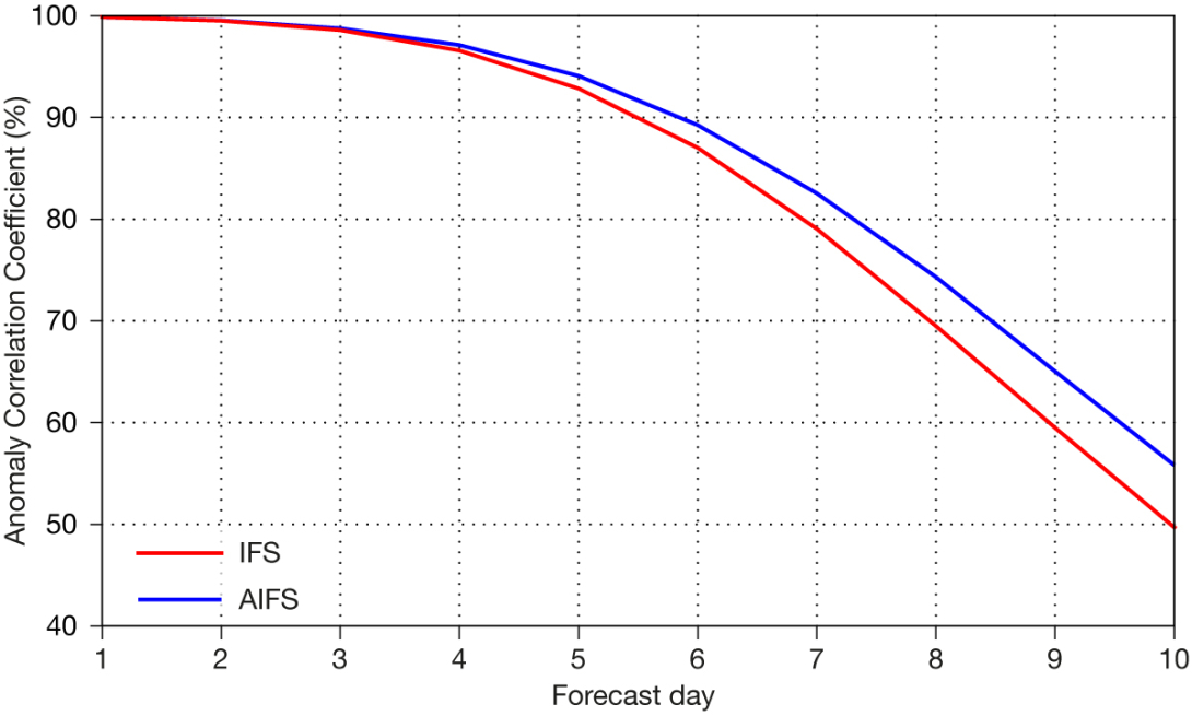
11 minutes ago, Go Kart Mozart said:
Ahh, it's exaggerating the block. AI has nothing like that...it shows a different problem, a consolidated bullseye vortex over James Bay.
Speaking of AI, I have been watching it closely. It seems to work rather like an ensemble...very good beyond four days, not as good as the operationals within four days. I would surmise that it is better in the longer range because it does not make compounded errors like the operationals. Within four days, the operationals are better as they are making a detailed analysis of the current atmosphere rather than just recognizing patterns.
Not my observation, but I've seen chatter about how the AI ECMWF has been showing more run to run consistency (i.e. no wild swings).
Of course the question is whether this is a real confidence builder, or only perceived because of the run to run stability. In theory being able to quickly produce a large ensemble might be able to truly give us the kind of dispersion we need for probabilistic forecasting. BUT the problem with AI is that it needs history to train on, so if it has never happened before the model isn't going to create it like a deterministic might.
You aren't wrong about the day 4 or so difference though.
-
2
-
-
1 hour ago, Damage In Tolland said:
They never made anything public or released anything on the extent of damage there . Just hushed it all up under the rug.

On the NWS side of things, StormData will be finalized shortly, and the Service Assessment takes significant time to complete. I think the Buffalo blizzard took the better part of a year to complete all the interviews and compile information.
-
3 minutes ago, WxWatcher007 said:
If we can’t produce here we should just merge with the SE forum
South of the Pike can merge with the Mid Atlantic forum. Kevin can switch seasonally depending on which ASOS he is referencing.
-
1
-
-

-
1
-
7
-
-
4 minutes ago, dendrite said:
I had this on the wall of my dorm room next to Sarah Michelle Gellar
Difax charts sticking together.
-
1
-
-
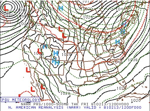
23 minutes ago, dendrite said:
Ah, the great high pressure of Feb 13, 1981. The event that truly got me into weather.
Will will remember synoptic class and Colucci saying that high pressure can be sexy too.
-
1
-
-
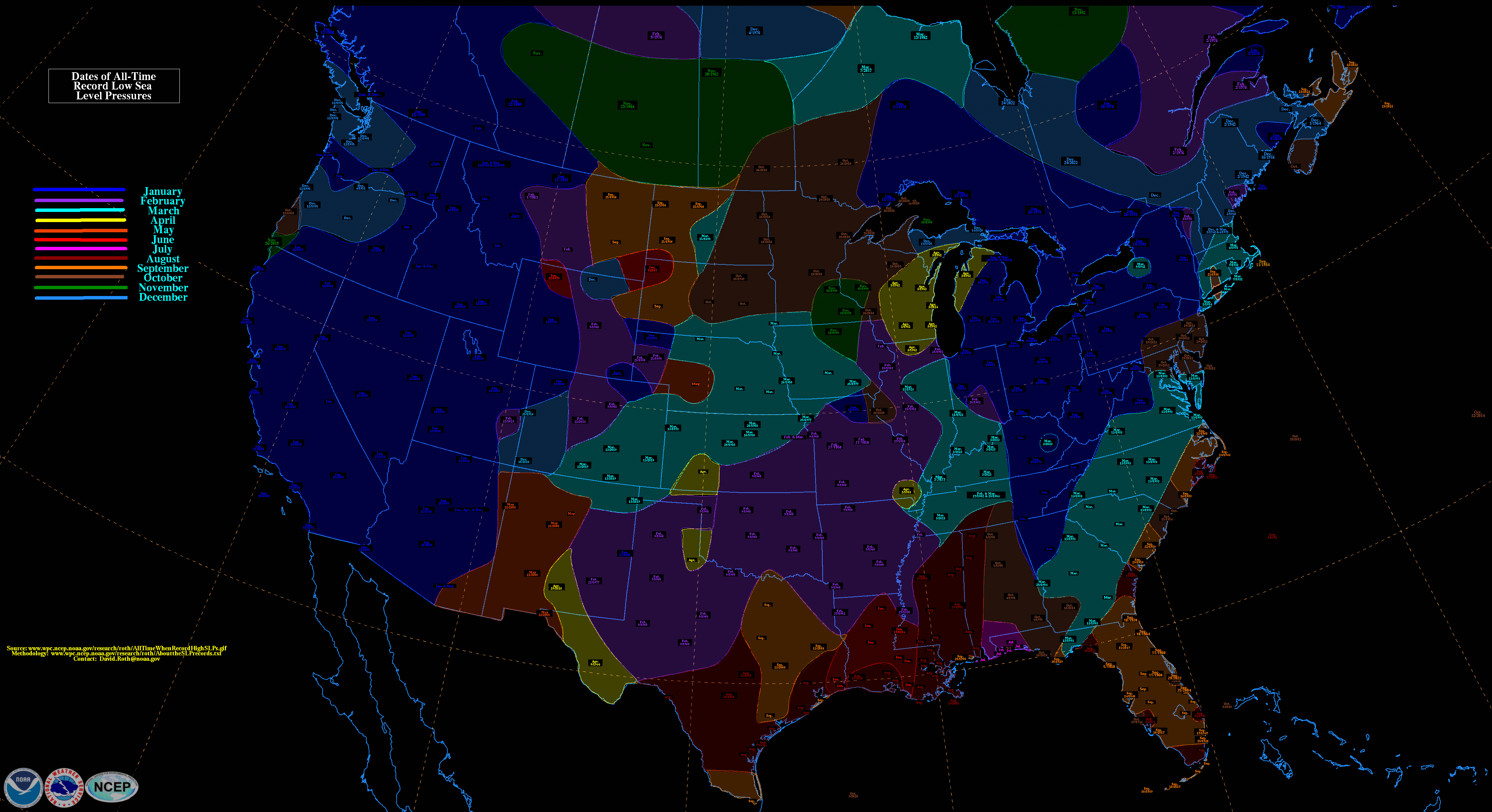
1 minute ago, HoarfrostHubb said:
Is there one for February?
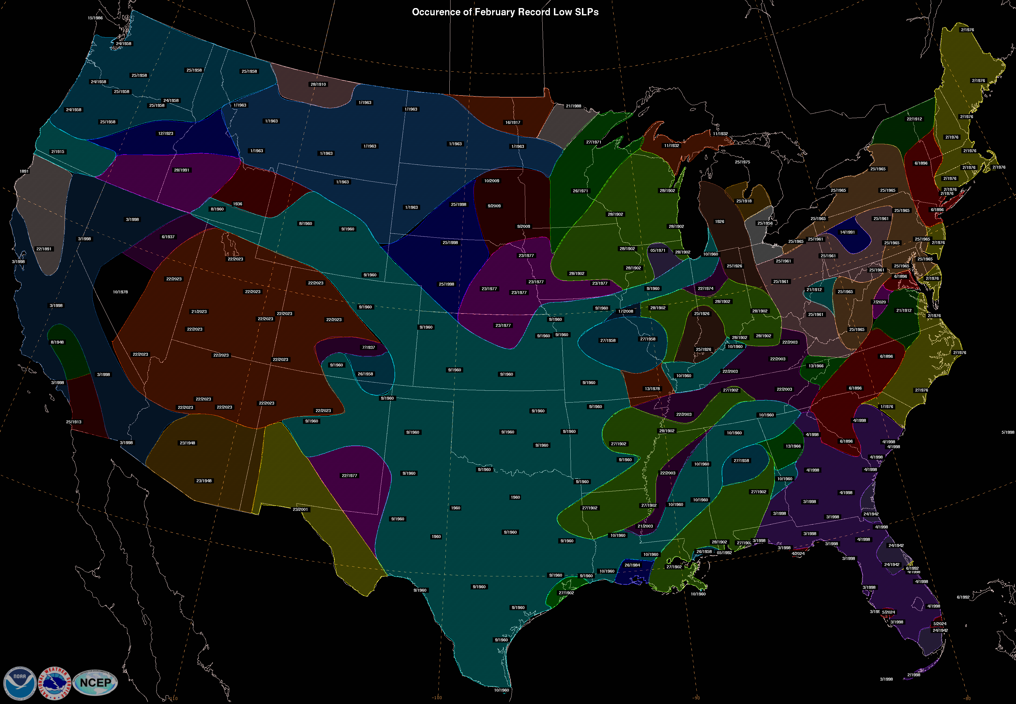
WPC tries to keep a running tally here: https://www.wpc.ncep.noaa.gov/research/roth/SLPrecords.html
-
2
-
2
-
-
17 minutes ago, ORH_wxman said:
Lol Jeff Smith and I were going nuts over that one. Freshman year at Cornell but we weren’t back from winter break yet…but we were IMing eachother the NGM and ETA outputs the night before. He was down in Plymouth, MA…for a brief moment it was looking like an epic blizzard of the century for immediate coastal MA.
The problem back then was the Euro only came out once a day…12z run but not until like 8pm at night, lol. So when you were viewing 00z runs, you always had in the back of your mind, “I wonder if the Euro will say anything remotely similar tomorrow”.

Me and you learning how to forecast with the NGM.
-
2
-
-
11 minutes ago, ma blizzard said:
This would have led to some epic melts ..

The March 1914 shows up on a lot of monthly low pressure records for the area too. Of course to get monthly low pressure records you usually need the storm to track over your backyard, which tends to be bad for snow. So a lot of our lowest pressure are written on Cleveland's Dead Sea Scrolls.
-
5
-
-
1 minute ago, ORH_wxman said:
There was a storm I recall that went into the upper 940s in January 2000…wanna say it was 1/21/00….the old NGM model the day before the event backed it close enough that it was giving 4” of QPF to E MA coast and Harvey Leonard started honking. ETA was trending west too but not quite as crazy…but still big QPF. The NGM was usually dry-biased so it was eye-popping to see those numbers.
It ended up scooting east and just scraped us with a few inches. I think the storm annihilated Hazey’s area in Nova Scotia.
Of course you do.
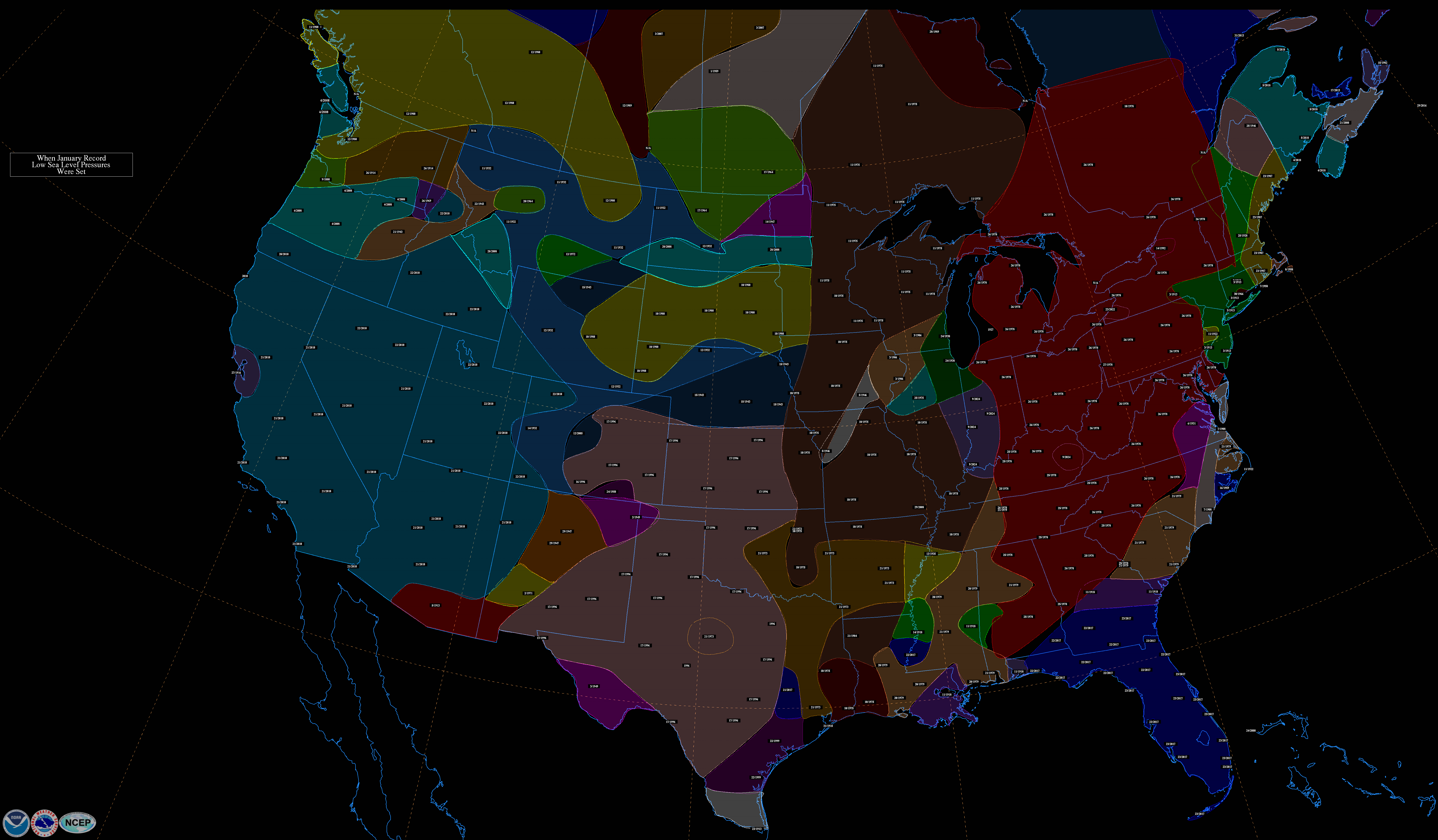
For half of Nova Scotia, that's the record low January pressure.
-
1
-
2
-
-
1 minute ago, Hoth said:
1938 cane around 938 at landfall I believe. Sandy around 940, but that was obviously Jersey. 2018 has gotta be at the top for winter systems.
Pretty cool to see that little oval of September 1938 within a sea of cool season bombs.
-
3
-
-
9 minutes ago, CoastalWx said:
Near our latitude? Pretty sure never?
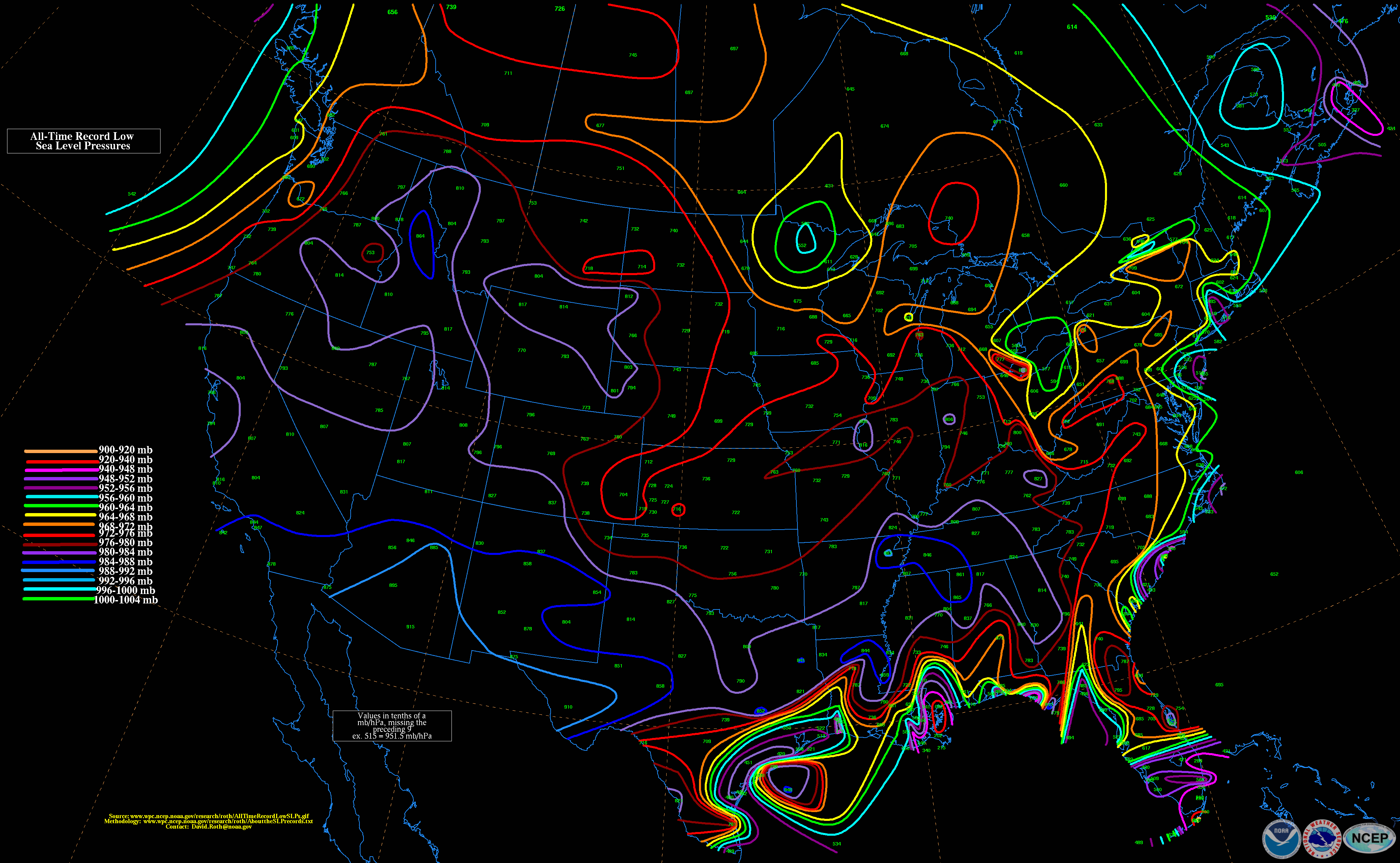
Those 940s are all tropical too.
January 2018 is probably the most prominent in my mind (949 I believe), but I don't have a steel trap for dates and events like Will. My brain is more of a wet paper bag these days.
-
3
-
3
-
-
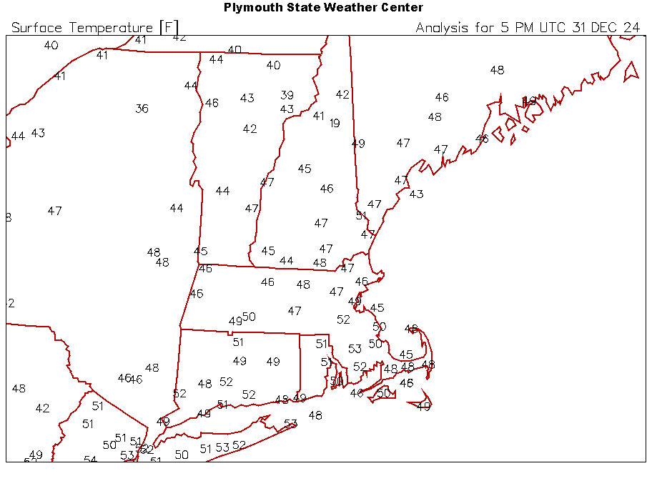
14 hours ago, dendrite said:
Drizzle intensity is determined by visibility just like snow.
1/4sm or less is +DZ. DZ is >1/4sm and <=1/2sm. -DZ is >1/2sm.
But yeah you never really see it in obs except for some stray AWOS sites. Usually the vis reduction gets attributed to fog so in ASOS METARs you see -DZ FG.
I’ll assume the forecast algorithms just see the visibility forcecast with the drizzle forecast and if there’s 1/4sm in the grids “heavy drizzle” gets regurgitated in the wording.
Likely what happened here is that dense fog (+FG) was added to the grids, which carries a 1/4 mile visibility. Then drizzle was added and intensity was based off visibility (which was 1/4 mile because of the fog) so you get +DZ.
But in reality I'm not sure I've ever seen a forecaster explicitly forecast DZ or +DZ, it's almost always -DZ.
-
1
-
-
17 minutes ago, Damage In Tolland said:
Today’s high temp was colder than yesterday at 27.5 vs 29 yesterday. These no mix days the temp doesn’t rise or fall too much this time of year
Deep winter.
-
3
-


Joker January
in New England
Posted
He's starting to get flashbacks to 2010.