

OceanStWx
-
Posts
20,131 -
Joined
-
Last visited
Content Type
Profiles
Blogs
Forums
American Weather
Media Demo
Store
Gallery
Posts posted by OceanStWx
-
-
1 minute ago, 40/70 Benchmark said:
Good luck with that.
Good luck with what? All I'm saying is that it is pretty unique that all the clusters' high end goalposts are decent events. Usually there is a total rat in there.
I'm still trying to tease out reasoning, but to me that suggests that timing is more of a factor in producing snow than amplification with this system. Aside from holiday travel aspect, I'm pretty skeptical still.
-
 1
1
-
-
59 minutes ago, CoastalWx said:
That Friday low on the gfs is still an interior deal, but would include many more vs for NNE. Potentially into the 128-495 area.
I think the rest of the coastals peeps wait until after 12/5. Maybe a few flurries or shsn next week.
Interesting system for the cluster analysis. There are definitely clusters (the flatter ones) that have lower mean snowfall, but all of the clusters have a solid 90th percentile event. So even the upper end of the flat members can produce a good low end warning event.
-
6
-
-
4 minutes ago, Typhoon Tip said:
do you think those kinds of tornadoes might be assisted by some sort of raging synoptic forcing
Definitely going to have synoptic forcing there, but my gut feeling is that these were more waterspouts moving onshore vs supercells.
-
11 minutes ago, tamarack said:
Here it was 2005, a modest 3.7" but our daughter/SIL were visiting and their (then) home at GSP didn't offer much for snow. We had moderate SN without a breath of wind for most of the daylight hours. (Only later did we learn about the EF-1 and EF-0 tornados in the midcoast. First cold-air tors I'd ever heard of.)
I need to go back and try and case study that one (much harder with ::gulp:: data 20 years old), but IWI started the day with 1/4 +SN and ended up with tornadoes not too far away after climbing to near 45 degrees. Must've been warmer on the other side of the warm front too.
Buoy water temp at the LNB was like 47 too, so probably had really steep lapse rates from the water to the 3 km level.
-
Just now, Lava Rock said:
meh, oct record is 80F, 1946
The November record will get there eventually.
We tied the previous record of 74 in 2020, and then broke it in 2022 (75).
-
 1
1
-
-
1 hour ago, CoastalWx said:
Why does Phil keep posting sad emojis? Enjoy it. Record highs possible tomorrow. At least we know this weather overachieves compared to winter.
PWM could break the all time Novie high on Friday. Let's do it!
-
1
-
-
2 hours ago, OceanStWx said:
Very much in flux at the moment. Essentially the FAA pays the NWS for roughly 90 mets to staff CWSUs to handle IN FLIGHT forecasts (local WFOs handle the takeoff/landing forecasts). The FAA has been looking to cut costs for years and the CWSUs always seem to be on the chopping block. It appears this time they really tried to make the clean break, but there is plenty of negotiating going on behind the scenes.
Local WFOs are not equipped or staffed to be able to handle briefing the FAA on demand, so that's not going to be the solution. Either they come up with a new agreement (maybe reduced staffing?) or they'll contract that forecast out to a company like Scott's. But the key is that they need some centralized entity to collaborate with the FAA. Because it's not just about the in route forecast, it's maintaining "gates" for flights to fly through on the way to the airport. You can't have Southwest and Delta winging it around thunderstorms, you need to the FAA to tell them which heading and what flight level to maintain so you don't have collisions.
As an addendum, almost all the articles I've read have stated the FAA is opting for some sort of automated computer based software for in route weather decision making, but none of the articles describe what that is.
I would have a hard time believing there is computer software at this time that can make decisions about air traffic routing, but dumping people in favor of a computer would certainly save money.
-
1
-
-
On 10/25/2024 at 8:19 AM, CoastalWx said:
Used to be. I moved away from forecasting and got into the corporate side of the business. Although that part got divested and I’ve been doing work on other products, but I miss the weather stuff so we’ll see what happens in the future.
Anyways I still keep close tabs on the old team. I’ve heard rumors that this may happen, but I have no idea what will substitute in place. They’ll need someone to do that work for general aviation. Many commercial airlines have their own mets and that’s where my previous work was.
On 10/25/2024 at 9:55 AM, tunafish said:Appreciate the context. Yeah, I would have to think someone has to do that work. Can't have planes routinely falling out of the sky.
Very much in flux at the moment. Essentially the FAA pays the NWS for roughly 90 mets to staff CWSUs to handle IN FLIGHT forecasts (local WFOs handle the takeoff/landing forecasts). The FAA has been looking to cut costs for years and the CWSUs always seem to be on the chopping block. It appears this time they really tried to make the clean break, but there is plenty of negotiating going on behind the scenes.
Local WFOs are not equipped or staffed to be able to handle briefing the FAA on demand, so that's not going to be the solution. Either they come up with a new agreement (maybe reduced staffing?) or they'll contract that forecast out to a company like Scott's. But the key is that they need some centralized entity to collaborate with the FAA. Because it's not just about the in route forecast, it's maintaining "gates" for flights to fly through on the way to the airport. You can't have Southwest and Delta winging it around thunderstorms, you need to the FAA to tell them which heading and what flight level to maintain so you don't have collisions.
-
4
-
-
6 hours ago, dendrite said:
Nevermind…I see that the CLI report is using only the airport extremes and not the threaded history.
Correct. The move from downtown to the airport was too big a change to thread.
-
47 minutes ago, Typhoon Tip said:
so ... both the met and mav machine/mos coverage are right around 70 for sat maxes along the bdl-fit-ash-bed arc of the interior.
the 850's are ~ +13c ... there's a light w to sw flow through the region, with way < 50% ceiling level rh values, while a neutral-dvm column. in other words, unadulterated sun.
it's an interesting test here, because those metrics in that relationship should synergize ( at least some ...) warmer, while at the same time it's tough to ignore the sun is nearing the southern tree line at zenyth - i.e., getting tepid by now.
the straight up adiabat from 13 is about 74 or 75, but that doesn't include the 2-meter super adiabatic slope temp... which can be 3 or 5 f above the adiabat after april 1 or so. not so sure about october 17 and fade away jump shots tho.
it's not like the models can't 'see' the warmth entirely ... mex is over 75 on monday. but i'm curious if we can get an 80 out of the climo sites per the course of this sat - next tues ...
Keep in mind that the cool season equations were implemented 10/1 and the transition buffer ended on 10/15.
-
4 hours ago, tamarack said:
No doubter this morning, 26° with thick frost and a 1/16" skim on the water in the washtub. Almost time to empty the thing and store it. Saw 23 at IZG.
23 at least at SFM too in the sand pit.
-
1
-
-
7 minutes ago, tamarack said:
32 again this morning. We've touched 32 twice without seeing a frost but yesterday's 33 included a windshield-scraper morning. Nanoclimate?
This is why I hate frost advisories. It is so difficult to know exactly when frost will form.
I vote hard freeze at 28 and be done with it.
-
2
-
 1
1
-
-
2 minutes ago, tamarack said:
Some change numbers for a rural site are below. The Farmington co-op records began in 1893 and ended halfway thru October 2022 when the volunteer's health prevented his taking measurements and no one picked up the torch. (Very sad because this site has the most complete records for any Maine co-op I've found that dates from the 19th century. Only eleven months are missing and just one month after 1913.)
Up until September of 1966 the obs sites (several) were all in the town center. After that the site was 1.5 miles north of the center in a rural setting - one 2-lane road with scattered houses and with forest to the east, ag fields on the flood plain to the west. The numbers below are changes in temperature from the 1970s to the 2010s. ('60s omitted because 2/3 were in town, '20s omitted because only 2.8 years of obs, though the temperature rise was continuing.)2010s temps minus 1970s temps
Year DJF DJFM JJA
MAX 1.78 2.76 2.97 0.27
MIN 4.53 8.06 6.61 2.75
MEAN 3.08 5.41 4.58 1.51Those cold season changes are shocking. (But it's only one site)
Just passed Dennis' house the other day for the first time. They still have his NOAA observer sign up despite his passing last December.
We're absolutely seeing big cool season changes here. We know we have less snow cover days outside of the mountains. But we are also seeing more of what happened in December. Snow that falls in the mountains is "more ripe" and ready to melt when we have the inevitable rainer. In the past the snow would just absorb that rain and we'd move on to the next snow pattern.
-
2
-
-
12 minutes ago, CoastalWx said:
Well the Democrats did it.
The messenger shuffle was really just Ekster using the weather machine to screw western New England out of QPF the whole time.
-
 3
3
-
-
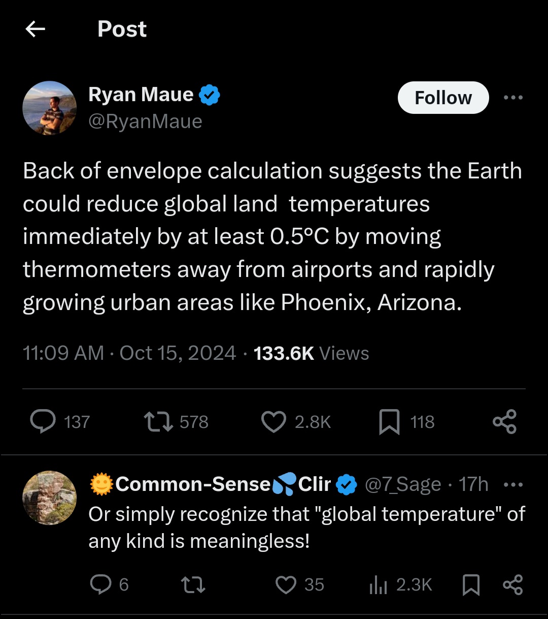
20 minutes ago, tunafish said:
Credit to OceanStWx for pointing this tweet out
https://x.com/RyanMaue/status/1846206890063142994
Not sure what's worse....this guy genuinely believing this would work or his followers in the comments adamantly agreeing.
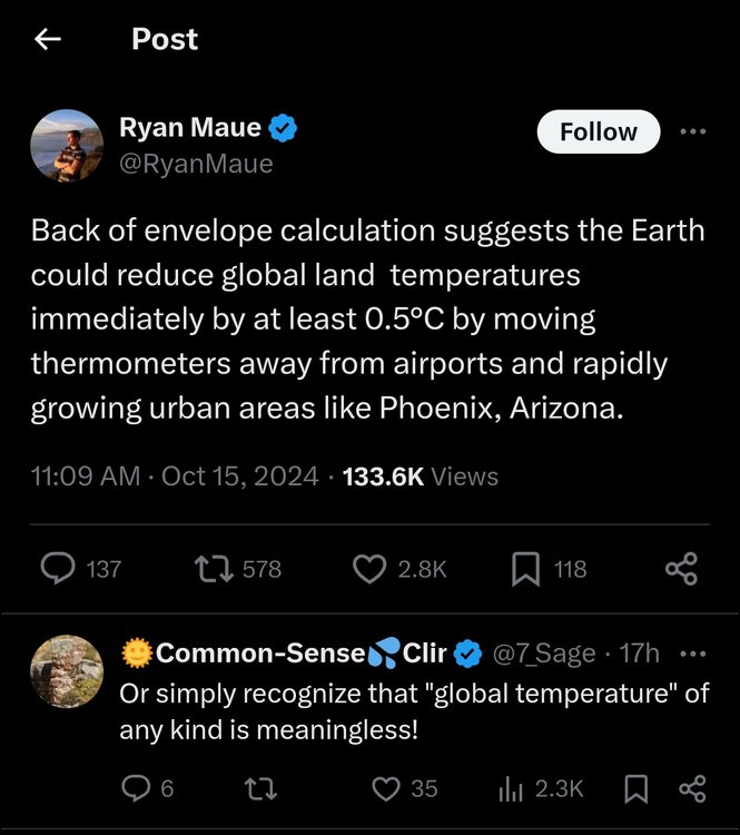
There is absolutely an argument to be made that urbanization around ASOSs is increasing temperatures by some margin, but like that's where people live and those are real temperatures.
We know temps are rising in both urban and rural settings, and land use changes are absolutely a driver of changing climate (it's just not a fossil fuel driven change).
-
 1
1
-
-
6 minutes ago, tunafish said:
There's some CoCoRAHS observers near by. Not sure how consistent their data is, though. Basically how I ended up with you guys.
That is usually our first point of contact. Find the CoCoRaHS observers who have a solid reporting history. I know we've reached out to a few by CON.
The problem is that you have to be within so many miles of the ASOS and a similar elevation, etc. It's hard to find dedicated weather weenies that meet all those criteria.
-
1
-
-
33 minutes ago, dendrite said:
Anyone within 5 miles of CON want to get paid to measure snow for the NWS this season?
Yeah I was going to advertise this too. It's getting harder and harder to find someone to do this for us. We lost AUG years ago and still haven't replaced the observation, for the state capital no less.
-
1
-
-
The winter equipment install happens today for @tunafish, the season is officially open for business.
-
3
-
-
12 minutes ago, dendrite said:
Not really. Mine struggles to keep flower buds through winter, but the mild 23-24 gave me a heavy fruit set before the grey rats got them. I’m looking to get a Contender and PF-24C for next year. They’re 2 of the hardiest with late flowering.
I had a great fruit set this year too, but I think leaf curl got me and the fruit shriveled up and fell off. I have one lonely peach left. (Redhaven)
-
4 minutes ago, bobbutts said:
Cell by Alton shows 3.5" hail icon on grlevel3. About as large as I can remember seeing. Wonder what size is reaching the ground?
Algorithms might be getting tricked by some of the bad data due to scatter spikes. But I could see siggy hail in there.
-
1
-
-
2 minutes ago, Sey-Mour Snow said:
No
Just a primer for Debby
-
1
-
-
On 7/14/2024 at 11:08 AM, dendrite said:
CON +6.4
MHT +6.3
PWM +4.2So DAW seems a good 2-3F too warm.
@OceanStWx Have you guys had any suspicions about DAW at the office?
I haven't been at the office since April, so I suspect I know nothing. I hadn't seen any email traffic about it, but that doesn't mean it wasn't being discussed on the internal chat.
-
56 minutes ago, tunafish said:
Maybe not day 10, but how about day 14?

Two feet after the equinox to claw my way to normal snowfall. Just how you draw it up in the pre-winter meetings.
-
1
-
2
-
1
-
-
As someone who has never experienced totality, I'm sure it looks the same way just before totality arrives, but seeing the eclipse shadow pass JUST to our north was pretty cool in its own right.
We took the kids out of school and drove as far north as my in-laws (99.12%), but we weren't about to trap ourselves in the car with them in the traffic to the north. Dark enough to see Venus and Jupiter, the kids got a kick out of it.
-
2
-
Blowvember - and not named for wind potential
in New England
Posted
Oh definitely not SNE. I would amend my previous post to say north of the Pike.