

OceanStWx
-
Posts
19,758 -
Joined
-
Last visited
Content Type
Profiles
Blogs
Forums
American Weather
Media Demo
Store
Gallery
Posts posted by OceanStWx
-
-
11 minutes ago, dendrite said:
I could probably walk 5 minutes to peas.
Please report only your largest failstones
-
 2
2
-
-
2 minutes ago, weatherwiz said:
Looks like a Watch coming soon!!!!
I love the shade SPC throws about wind. "Isolated 45-60 mph gusts"
-
27 minutes ago, CoastalWx said:
Yeah I was impressed by the hail in downtown BOS. That was the last morning/aftn severe day I can recall. I think we had some sort of EML in place too?
I imagine some non-standard layer had 7+ lapse rates, but our 17z sounding had 6.5 from 700-500. Huge CAPE (2500) for around here, and 50 knots shear.
-
 1
1
-
-
30 minutes ago, CoastalWx said:
Big day. Morning severe (tree hit by lightning across street from me) and my wife at Northeastern University recording quarters raining down in the late day severe.
Half dollars at our old condo. Had my wife (then girlfriend) running around the deck to find the largest stone because I was at work.
-
1
-
 1
1
-
-
22 minutes ago, CoastalWx said:
72.5 for high. Only a few above our average high for Christmas.

Average temp at BOS on 12/23 is 33.3 degrees. You have to walk it back to 12/14 before you get an average temp warmer than that (33.7).
-
3
-
-
17 minutes ago, CoastalWx said:
Indeed BOX said there was no tornado in Chaplin. Lol.
@Damage In Tolland got his tree topper and nothing more.
-
1 hour ago, tamarack said:
Jeff's area has the bigger mountains, 4,000-footers with up to 3,000 feet altitude gain. If you would rather not walk up a Sugarloaf ski trail, the Caribou Pond Road west of the 'Loaf is crossed by the AT, offering a more natural route up to Maine's 2nd tallest mountain. Tumbledown has very heavy use though midweek would likely be okay, gain is 1500-1800 feet, depending on which summit one takes. One route is very steep, almost cliff-like (so I've been told). Shorter hikes include 2 different Bald Mountains. Perkins Bald is on Rt 156 only 7-8 miles from Wilton. Signage is iffy and parking quite limited. Altitude gain is a bit over 1,000 feet. The other Bald, in Oquossoc (part of Rangeley) is an hour's drive, though a quite pretty one with a better chance of seeing moose. That Bald is reached by Bald Mountain Road, off Rt 4 about 500 feet from that highway dumping into Mooselook Lake. I've not been up the Perkins Bald but love the one in Oquossuc. That mountain lies between Mooselook and Rangeley Lakes, has good parking and a big sign (and a vault toilet), and offers 3/4 mile of uphill thru forest followed by 1/2 mile+ of rock scramble. Some pitches look daunting but 3 years ago my then-5-year-old grandson had no trouble. Perkins Bald has open rock at the summit, Oquossuc has a 30-foot observation tower made for the lower section of an old firetower.
You can learn more about Bigelow, Tumbledown and Oquossuc Bald at Maine.gov/agencies/Agriculture, Conservation and Forestry. Searching for Maine Bureau of Parks and Lands might get you there more quickly.
We've had wonderful lobster rolls at the seafood place on Rt 2 just east from the center of Farmington, but you might get an even better one at the coast.
But sounds like the access road is a mess from all the rain/flash flooding.
Also yes, if you head up from the Loop Trailhead it is quite steep, but the Brook Trail is more gradual. I wouldn't recommend looping it down the to the Loop Trailhead though, because you have to climb down through the ladders and rock cave. Going up is much easier in that stretch I think.
-
1
-
 1
1
-
-
Just now, Ginx snewx said:
Head scratcher to me. Doesn't really match what the radar said, with a two scan TDS for Easton that's more than 400 yards. And Brockton definitely had a TDS too. Microburst don't throw debris into the air.
-
2
-
-
2 minutes ago, JJBASHB said:
It really is, especially with EF0-1 tornados that end up 50-150 yards wide.
Yeah most of the time the tornado path looks like it's around 300 yard (but some of that could be RFD damage, hard to say when it's all sporadic trees), and at its widest around 450 yards. From the centerline to Ridgewood was nearly 3/4 of a mile. Far enough that could've been NBD. Given the environment, the RFD would've been the next windiest part of the storm, and a good deal south of Ridgewood. This wasn't the type of storm with a massive forward flank wind on it.
-
1
-
-
7 minutes ago, TauntonBlizzard2013 said:
Interesting…. Like I said above, my sister in law lives 2 streets over from Kennedy circle and there isn’t so much as a twig down there.
couldn’t have been very wide or on the ground very long.
Based on the warning motion vector and the damage path, it was on the ground for around 8 or 9 minutes. Which matches the TDS, it was there for two scans which is at least 4 minutes but not quite 10.
It's also clear that this wasn't continuously on the ground either. There are lots of roads it crossed without any damage indicated by BOX so far. So a weaker circulation that was "skipping" is likely.
-
4 hours ago, TauntonBlizzard2013 said:
School St is a mess. Everything else is fake news
One dead tree down in someone’s front yard on beaver dam rd. Nothing on heath rd or prospect st.
Not sure any of it is a tornado though
It's definitely going to be a tornado. I'm following along as BOX uploads the damage points into our system, and it looks like mostly (all?) tree damage. High end EF0/low end EF1 type stuff. The still photo in the tweet above you can get the sense of what BOX is looking for beyond the damage itself. You can see the downed trees, while chaotic, are crossing paths showing convergent wind vs divergent straight line.
-
2
-
-
1 minute ago, CoastalWx said:
Multiple reports of trees and wires down in Easton.
I'm listening to the scanner now and it's all hit and run chatter.

-
Just now, TauntonBlizzard2013 said:
My sister in law lives right over there and she said they got nada.
Unless you lived in those subdivisions it may not have been much to write home about.
-
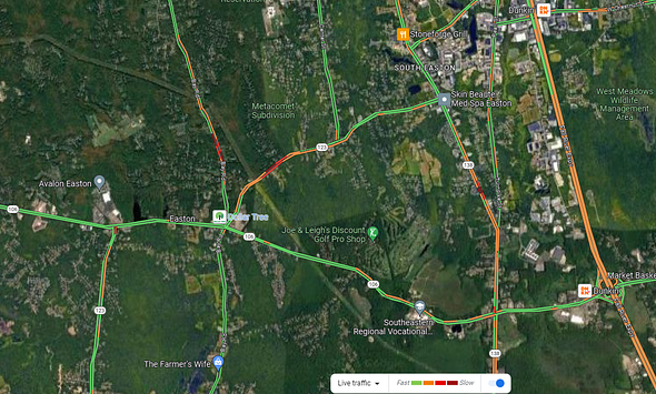 3 minutes ago, TauntonBlizzard2013 said:
Bloody hell
That traffic stoppage is a telltale sign that some
 occurred.
-
3
-
-
Just now, Chrisrotary12 said:
Which radar and level you looking at?
BOX. Like around 0024z and 0030z. 0.9 degree slice is a little less noisy than 0.5.
-
Just now, TauntonBlizzard2013 said:
Huh?
There's going to be tornado damage just north of 495 near Easton/Raynham, and then the south side of Brockton.
-
1
-
1
-
-
3 minutes ago, Modfan2 said:
Picture from Allen Hill in Brooklyn looking west to Chaplin. 1.30” from this round
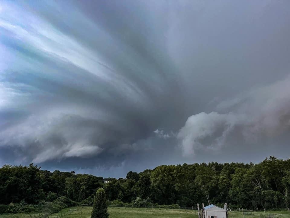
That kind of sculpted updraft shows you just how fast it was spinning aloft.
-
3
-
-
Definitely two TDSs there in Bristol/Plymouth Counties.
-
1
-
-
3 minutes ago, weatherwiz said:
Confirmed tornado over Chaplin
3 minutes ago, SRRTA22 said:Tornado observed
Radar confirmed, so nobody has actually spotted one.
-
1
-
1
-
-
Really spinning like a top in the mid levels. There's enough juice below 10 kft that we could get a hose to the surface.
-
2
-
-
There's a little BWER on that UCONN cell. I would pull the trigger I think.
-
1
-
-
4 minutes ago, Damage In Tolland said:
Posted video . Reminds me of the tree topper cell we had 7-8 years ago
STP is near 1, so I could see pulling the trigger once rotational velocity is over 25 kt. Right now it's about 23.5 kt near Manchester.
Pretty classic TOR problem of sidelobe contamination though.
-
Just now, Damage In Tolland said:
This cell over me spinning nicely
Pics or it didn't happen.
(You're not wrong though)
-
5 minutes ago, CoastalWx said:
Flaccid stuff
Skinny CAPE, no girth.
-
2
-
2
-
August model and weather disco
in New England
Posted
We'll get 'em next time.