MGorse
-
Posts
2,254 -
Joined
Content Type
Profiles
Blogs
Forums
American Weather
Media Demo
Store
Gallery
Everything posted by MGorse
-
Given these model solutions, the 700-850 mb frontogenesis is going to be insane. If correct, easily a period of 2-3 inches per hour.
-
The 00z NAM is like meteorological porn!
-
No comment.
-
Go by the legend range colors. The labeled numbers (i.e 1-14) are probability data being applied. Stupid, yes.
-
Blizzard watches no longer exist.
-
Holy shit!
-
Well hello there 18z NAM, I see you!
-
Impressive model trends today so far. If the storm ends up being intense and closer to the coast, there will be a zone of intense upward motion/frontogenesis resulting in 2+ inches per hour snowfall rates. Winds will be an issue, but it may be a challenge to achieve blizzard conditions as the snow could be too wet. It will be interesting to see how this pans out.
-
Just to clarify, Watches are not downgraded. They are upgraded or canceled.
-
Well now, maybe the GFS is not sniffing glue?
-
The recon data, as far as I know, is available for all to use.
-
Yup, most of the energy is onshore today. The recon is also for atmospheric river research/data.
-
Yes, there were recon data yesterday at 18z and 00z in the eastern Pacific. Looks like some recon data is scheduled again for 00z this evening.
-
The GFS sniffing glue or something?
-
Not surprised!
-

E PA/NJ/DE Winter 2025-26 Obs/Discussion
MGorse replied to LVblizzard's topic in Philadelphia Region
The 06z GFS certainly is a WOW, but that has to be over amplified! -
Early Monday morning 2/16 last minute event OBS/Discussion
MGorse replied to The Iceman's topic in Philadelphia Region
49 here currently. Some spotty grass showing now but still impressed with the snow cover hanging on. -
E PA/NJ/DE Winter 2025-26 Obs/Discussion
MGorse replied to LVblizzard's topic in Philadelphia Region

-
E PA/NJ/DE Winter 2025-26 Obs/Discussion
MGorse replied to LVblizzard's topic in Philadelphia Region
Well, the model trends have become interesting. -
E PA/NJ/DE Winter 2025-26 Obs/Discussion
MGorse replied to LVblizzard's topic in Philadelphia Region
The Global High-Resolution Atmospheric Forecasting (GRAF) model is a propriety, physics based, numerical weather prediction system developed by The Weather Company (an IBM Business) in collaboration with the National Center for Atmospheric Research (NCAR). -
E PA/NJ/DE Winter 2025-26 Obs/Discussion
MGorse replied to LVblizzard's topic in Philadelphia Region
We are required to use the NBM for the official NWS forecast. Through collaboration though we can edit that if it is significant enough. It is quite the touchy new policy that many are not happy with. It basically adds more work than saving time as we were told it would. NBM has its flaws plus it always lags behind at least one model cycle. -
It can vary.
-
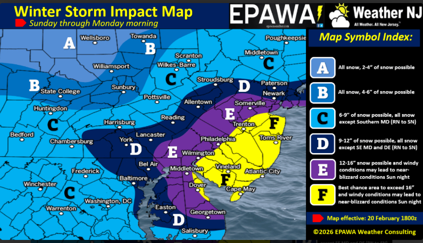
As of 1 PM... 7.4" at PHL. 6.6" at NWS Mount Holly
-
Changing to sleet here at NWS Mount Holly.