Ralph Wiggum
-
Posts
17,384 -
Joined
-
Last visited
Content Type
Profiles
Blogs
Forums
American Weather
Media Demo
Store
Gallery
Everything posted by Ralph Wiggum
-

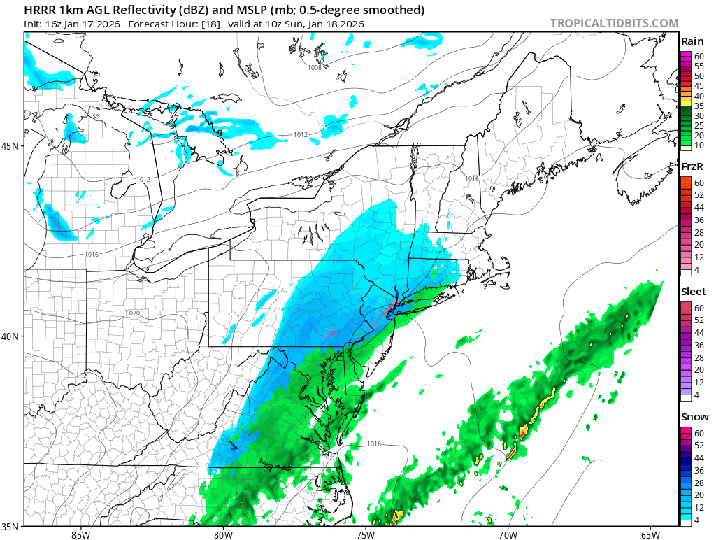
E PA/NJ/DE Winter 2025-26 Obs/Discussion
Ralph Wiggum replied to LVblizzard's topic in Philadelphia Region
4.25" here in Telford, winding down. 4" back home im told and still ripping. BTW, tomorrow 5am. @RedSkyall is right in the world....daytime snow back to back days!
-
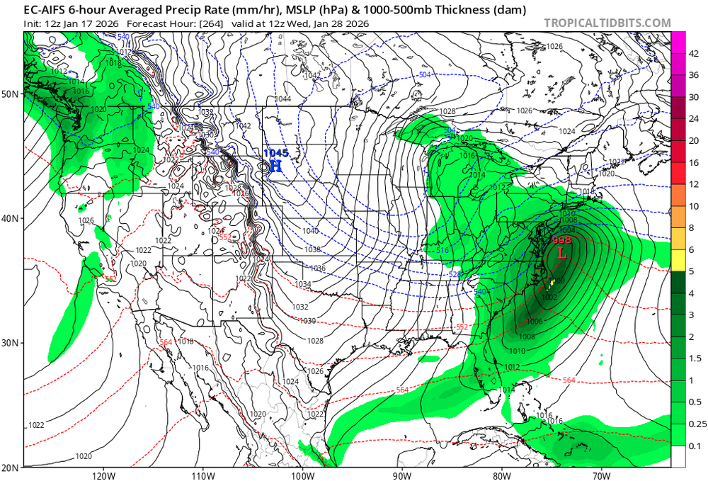
Euro AI puts all its eggs in the Jan 27-29 basket. Pretty sure most of us would take this look at this range. Eta: just a triple phaser based on h5 vort, nothing to goon over
-
Just some good blocking as nacho said.
-
But in a Nino we dont always have the cold air with the NS being more lax. We can thank this Nina for the abundance of arctic air around, imho.
-
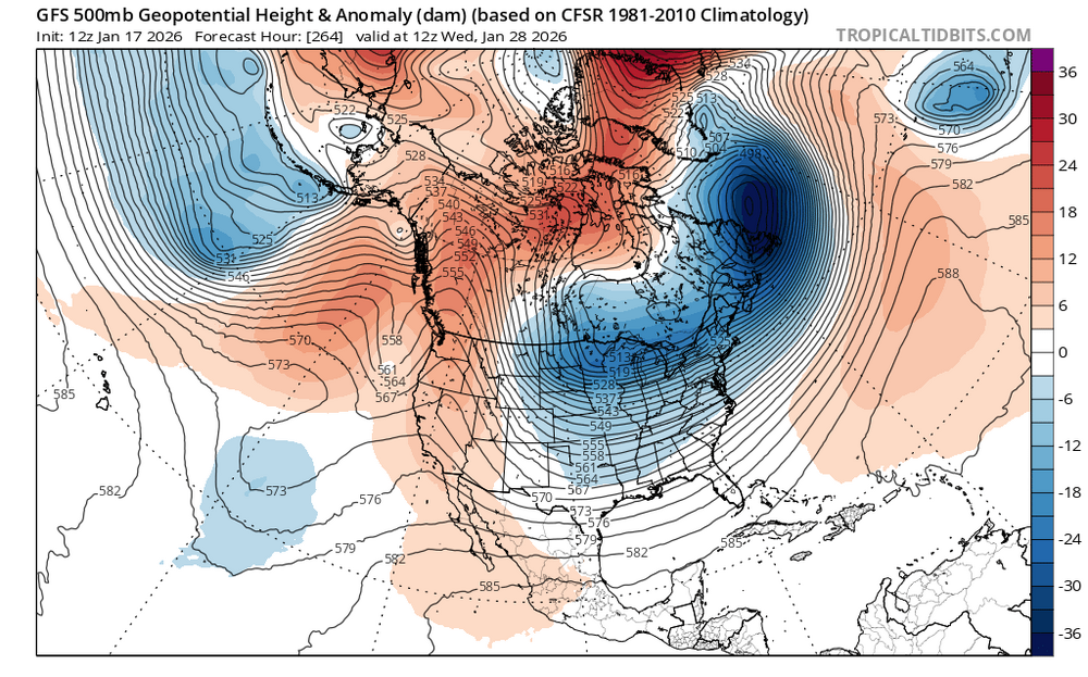
Its the op so grain of salt, but geez....look out West says stj is just beginning to warm up. And those looks up top and out West are chef's kiss
-
Unclear if the 25th is the big one or 29th, or both. But 25th can hit followed by an Archabault near the 29th as the NAO briefly flips positive. Loving the loaded pattern. Sometimes the last in succession when a tellie flips is the one we do this hobby for, so we'll see.
-
Looks like as pna builds back in at 216 a split flow develops with stj energy feed undercutting the ridge.
-
And....even if this isnt exactly what we want, there is the next one on its heels a few days later. Roll the dice enough and we win.
-
Looks like the ice storm some were honking about.
-
Allen Iverson GFS has a BIG system on the 29th as well fwiw. Alot of fucking potential guys.
-
I think we have pieces coming out. There will be another behind this for the next window too imo. But THIS is nice! Where are Chuck and Arlington?
-
You know u wanna say it!
-
The Allen Iverson GFS buries the baja upper low in the SW fwiw. However, ensembles support it ejecting East attm.
-
Gooning as you do the pbp on this.
-
I have my eyes on the Baja Blast upper low around 144. Thats the thing I like for the 27-29 window. If that gets hung up out there im perfectly fine with several days of impulses ejecting east from that if the bowling ball doesnt hold together. Noted prior, biggest fail for that window attm is a slider or suppression. But we'll see. No ssense dissecting into too much detail on that at this point. Edited to fix typos from my fat ass fingers.
-
E PA/NJ/DE Winter 2025-26 Obs/Discussion
Ralph Wiggum replied to LVblizzard's topic in Philadelphia Region
Fv3 also bullish 2-4" additional tomorrow up here. Checking other mesos now -
E PA/NJ/DE Winter 2025-26 Obs/Discussion
Ralph Wiggum replied to LVblizzard's topic in Philadelphia Region
Puking marshmallows in Telford, 28F. Almost an inch. -
E PA/NJ/DE Winter 2025-26 Obs/Discussion
Ralph Wiggum replied to LVblizzard's topic in Philadelphia Region
WowWhat a difference once I got near ridge road.It really deteriorated quickly. Even 309 caved -
E PA/NJ/DE Winter 2025-26 Obs/Discussion
Ralph Wiggum replied to LVblizzard's topic in Philadelphia Region
Winter wonderland here , flakes flying on my way to telford -
Edited to say carolina coast, but still yeah, I'd chase
-
Sub 980 off of Carolina Coast is crazy op at range or not. Dont see that everyday. Full scale blizzard.
-
Heck of a storm signal and gaining some traction but still a long long way out.
-
Just an op run but good to see the consistent players run to run. Im happy with this run wrt general ideas for next week and forward.
-
Ways out there but man that period is still honking that ive been um, 'drooling' about.
-
Chuck/North Arlington system looks steady at 198. What's your take Randy? Ninja'd