yoda
-
Posts
63,097 -
Joined
Content Type
Profiles
Blogs
Forums
American Weather
Media Demo
Store
Gallery
Everything posted by yoda
-
Oh Day 1 Convective Outlook NWS Storm Prediction Center Norman OK 1128 AM CDT Thu May 15 2025 Valid 151630Z - 161200Z ...THERE IS AN ENHANCED RISK OF SEVERE THUNDERSTORMS ACROSS EAST-CENTRAL MINNESOTA...MUCH OF WISCONSIN...SOUTHERN AND WESTERN LOWER MICHIGAN...NORTHEAST ILLINOIS...NORTHERN INDIANA AND NORTHWEST OHIO... ...THERE IS A SLIGHT RISK OF SEVERE THUNDERSTORMS OVER PORTIONS OF VIRGINIA AND NORTHEAST NORTH CAROLINA... ... ...Central Appalachians/Mid-Atlantic... Large-scale height rises are expected across the region, but diurnal heating and orographic effects will aid in thunderstorm development across the higher terrain this afternoon. Northwesterly flow aloft will favor a southeastward storm motion within an environment of moderate/locally strong instability. 35-45 kts of northwesterly deep shear is anticipated, supporting supercell structures and clusters, posing a risk for large hail and damaging winds. The overall hodograph structure and resulting storm motion appears favorable for some very large hail over 2" in diameter as well. ..Mosier.. 05/15/2025
- 1,378 replies
-
- 2
-

-
- severe
- thunderstorms
- (and 2 more)
-
Oh okay then - I know this is more just to the S and W of most of us... But still don't see hatched hail around here very often... @high risk @George BM @Kmlwx @Eskimo Joe
- 1,378 replies
-
- 3
-
-
- severe
- thunderstorms
- (and 2 more)
-
12z NAM Nest soundings suggest nastiness tomorrow evening into nighttime
- 1,378 replies
-
- 2
-
-
- severe
- thunderstorms
- (and 2 more)
-
Which ones?
-
I know we've mentioned the trigger issue, but damn, that 18z NAM sounding for DC metro at 00z Saturday
-
https://www.espn.com/nfl/story/_/id/45146544/rb-derrick-henry-agrees-two-year-30m-extension-ravens Congratulations Ravens fans
-
What do you think of the MCS complex and increasing MLLR/hodographs early Saturday morning the 12z NAM comes up with?
-
Someone broke the 12z NAM Nest soundings at the end of its run 5000-6000+ SBCAPE because DPs are in the upper 70s
- 1,378 replies
-
- 3
-

-

-
-
- severe
- thunderstorms
- (and 2 more)
-
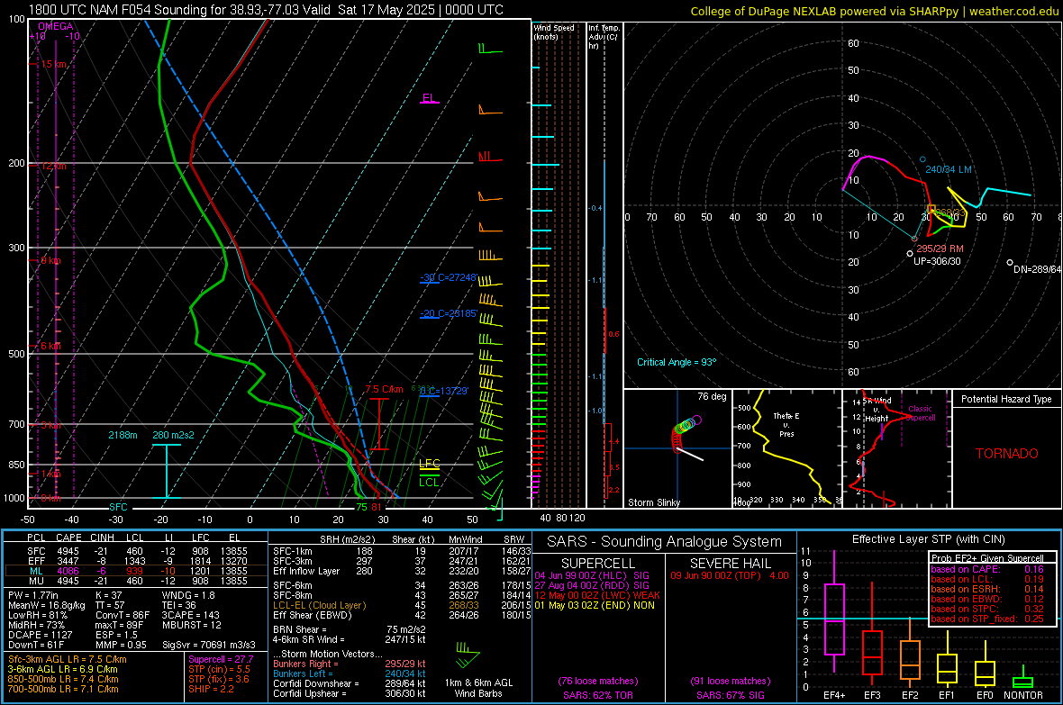
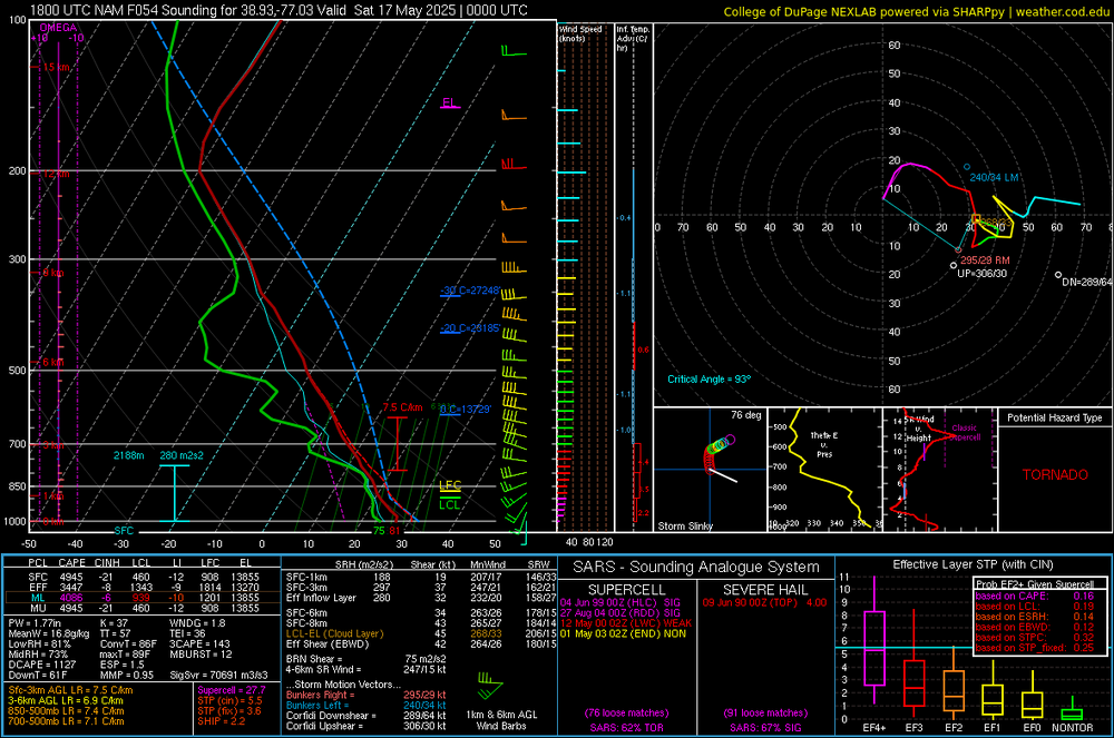
12z NAM continues with the significant hail in the SARS... probably overdone with SBCAPE - suggesting 4000 J/KG... but 21z Friday near DCA is 88/73 Then it really lights up again around 09z SAT... ML Lapse rates are near 8 C/KM and hodos quickly become curved and elongated
- 1,378 replies
-
- 1
-
-
- severe
- thunderstorms
- (and 2 more)
-
Some unheard of values for our region showing up on some of the 00z NAM soundings re SHIP... seeing 2.5 to 3.5 values. Supercell composite lights up quickly Friday afternoon and evening... and lots of significant hail showing up in the SARS, especially some 2" to 4" ones June 9 1990 00z IAD 3.50" is one of them @high risk @Kmlwx @Eskimo Joe
- 1,378 replies
-
- 1
-
-
- severe
- thunderstorms
- (and 2 more)
-
Flash Flood Warning National Weather Service Baltimore MD/Washington DC 935 PM EDT Tue May 13 2025 ...FLASH FLOOD EMERGENCY FOR THE STANARDSVILLE, RUCKERSVILLE, AND DAWSONVILLE AREAS INCLUDING THE HIGHWAY 29 AND 33 CORRIDORS... The National Weather Service in Sterling Virginia has issued a * Flash Flood Warning for... Greene County in central Virginia... * Until 1245 AM EDT. * At 935 PM EDT, emergency management reported thunderstorms producing heavy rain in The Stanardsville, Ruckersville, and Dawsonville areas including the Highway 29 and 33 corridors. Between 3 and 6 inches of rain have fallen. The expected rainfall rate is 1.5 to 2.5 inches in 1 hour. Additional rainfall amounts of 1 to 3 inches are possible in the warned area. Flash flooding is already occurring. This is a FLASH FLOOD EMERGENCY for The Stanardsville, Ruckersville, and Dawsonville areas including the Highway 29 and 33 corridors. This is a PARTICULARLY DANGEROUS SITUATION. SEEK HIGHER GROUND NOW! HAZARD...Life threatening flash flooding. Thunderstorms producing flash flooding. SOURCE...Emergency management reported. IMPACT...This is a PARTICULARLY DANGEROUS SITUATION. SEEK HIGHER GROUND NOW! Life threatening flash flooding of low water crossings, small creeks and streams, urban areas, highways, streets and underpasses. * Some locations that will experience flash flooding include... Stanardsville... Ruckersville... Lydia... Amicus... Mcmullen... Haneytown... Quinque... Saint George... Fletcher... Burtonville... Shady Grove... Newtown... Dawsonville... Mission Home... This includes the following Flood Prone Roads... Mutton Hollow Road near Spotswood Trail, Carpenters Mill Road at Route 607, Advance Mills Road and and Route 617, Westview Road and Deep Step Drive, Seminole Trail at White Run near Route 645, Route 621 along South River near Madison Road, 3300 Block of Spotswood Trail, Garth Road near Swift Run, Dyke Road near Blue Run near Spotswood Trail, South River Road near The South River, Dundee Road at The South River, Middle River Road near The Conway River, Octonia Road at South River Road and Celt Road near Amicus Road. PRECAUTIONARY/PREPAREDNESS ACTIONS... Move to higher ground now! This is an extremely dangerous and life-threatening situation. Do not attempt to travel unless you are fleeing an area subject to flooding or under an evacuation order. Turn around, don`t drown when encountering flooded roads. Most flood deaths occur in vehicles. Be especially cautious at night when it is harder to recognize the dangers of flooding. && LAT...LON 3836 7843 3832 7838 3832 7836 3829 7836 3829 7835 3828 7835 3827 7829 3819 7837 3828 7866 3829 7865 3829 7864 3834 7855 3836 7854 3837 7853 3839 7852 3840 7850 3848 7845 3845 7844 3841 7844 3838 7842 FLASH FLOOD...OBSERVED FLASH FLOOD DAMAGE THREAT...CATASTROPHIC EXPECTED RAINFALL RATE...1.5-2.5 INCHES IN 1 HOURS
-
BULLETIN - EAS ACTIVATION REQUESTED Flash Flood Warning National Weather Service Baltimore MD/Washington DC 1007 PM EDT Tue May 13 2025 ...FLASH FLOOD EMERGENCY FOR MADISON COUNTY BETWEEN THE CREST OF THE BLUE RIDGE AND HIGHWAY 29... The National Weather Service in Sterling Virginia has issued a * Flash Flood Warning for... Madison County in northwestern Virginia... * Until 115 AM EDT. * At 1007 PM EDT, emergency management reported widespread flooding and water rescues in Madison County between the crest of the Blue Ridge and Highway 29. Between 4 and 7 inches of rain have fallen. The expected rainfall rate is 0.5 to 1 inch in 1 hour. Additional rainfall amounts of 0.5 to 1 inch are possible in the warned area. Flash flooding is already occurring. This is a FLASH FLOOD EMERGENCY for Madison County between the crest of the Blue Ridge and Highway 29. This is a PARTICULARLY DANGEROUS SITUATION. SEEK HIGHER GROUND NOW! HAZARD...Life threatening flash flooding. Thunderstorms producing flash flooding. SOURCE...Emergency management reported. IMPACT...This is a PARTICULARLY DANGEROUS SITUATION. SEEK HIGHER GROUND NOW! Life threatening flash flooding of low water crossings, small creeks and streams, urban areas, highways, streets and underpasses. * Some locations that will experience flash flooding include... Madison... Big Meadows... Brightwood... Aylor... Banco... Haywood... Criglersville... Pratts... Syria... Graves Mill... Wolftown... Shelby... Aroda... Etlan... Hood... Rochelle... Oakpark... Leon... Twymans Mill... Fletcher... PRECAUTIONARY/PREPAREDNESS ACTIONS... Move to higher ground now! This is an extremely dangerous and life-threatening situation. Do not attempt to travel unless you are fleeing an area subject to flooding or under an evacuation order. Turn around, don`t drown when encountering flooded roads. Most flood deaths occur in vehicles. Be especially cautious at night when it is harder to recognize the dangers of flooding. && LAT...LON 3837 7812 3833 7808 3831 7811 3830 7810 3827 7815 3827 7818 3826 7818 3823 7822 3823 7825 3828 7830 3828 7835 3832 7836 3837 7843 3845 7844 3848 7845 3853 7844 3856 7838 3859 7838 3863 7834 3840 7810 FLASH FLOOD...OBSERVED FLASH FLOOD DAMAGE THREAT...CATASTROPHIC EXPECTED RAINFALL RATE...0.5-1 INCH IN 1 HOUR
-
Reverse psychology i see
-
Flood watch expanded northward and eastward Flood Watch National Weather Service Baltimore MD/Washington DC 125 PM EDT Mon May 12 2025 MDZ501-502-510-VAZ028-031-050-051-053>056-501-502-505-506-526-527- WVZ050>053-503-504-130130- /O.EXB.KLWX.FA.A.0004.250513T1000Z-250514T1000Z/ /00000.0.ER.000000T0000Z.000000T0000Z.000000T0000Z.OO/ Extreme Western Allegany-Central and Eastern Allegany-Eastern Garrett-Frederick VA-Clarke-Orange-Culpeper-Fairfax- Arlington/Falls Church/Alexandria-Stafford-Spotsylvania-Northern Fauquier-Southern Fauquier-Western Loudoun-Eastern Loudoun- Northwest Prince William-Central and Southeast Prince William/Manassas/Manassas Park-Hampshire-Morgan-Berkeley- Jefferson-Western Mineral-Eastern Mineral- 125 PM EDT Mon May 12 2025 ...FLOOD WATCH IN EFFECT FROM TUESDAY MORNING THROUGH LATE TUESDAY NIGHT... * WHAT...Flooding caused by excessive rainfall continues to be possible. * WHERE...Portions of western Maryland, including the following areas, Central and Eastern Allegany, Eastern Garrett and Extreme Western Allegany, Virginia, including the following areas, Arlington/Falls Church/Alexandria, Central and Southeast Prince William/Manassas/Manassas Park, Clarke, Culpeper, Eastern Loudoun, Fairfax, Frederick VA, Northern Fauquier, Northwest Prince William, Orange, Southern Fauquier, Spotsylvania, Stafford and Western Loudoun, and West Virginia, including the following areas, Berkeley, Eastern Mineral, Hampshire, Jefferson, Morgan and Western Mineral. * WHEN...From Tuesday morning through late Tuesday night. * IMPACTS...Excessive runoff may result in flooding of creeks, streams, and other low-lying and flood-prone locations. Low-water crossings may be flooded. * ADDITIONAL DETAILS... - While showers will spread into the area today, a prolonged period of moderate to heavy rain with embedded thunderstorms is expected late tonight into Tuesday night. Rainfall amounts of 2 to 4 inches are likely, with locally higher amounts possible along the eastern slopes of the Blue Ridge Mountains and Alleghenies. This rainfall may lead to scattered instances of flooding. - Please visit www.weather.gov/safety/flood for flood safety and preparedness information PRECAUTIONARY/PREPAREDNESS ACTIONS... You should monitor later forecasts and be alert for possible Flood Warnings. Those living in areas prone to flooding should be prepared to take action should flooding develop.
-
12z CMC is a deluge... 3 to 5"... everybody over 2" except DE
-
12z GFS looks like 1.5" to 2.5" for many through 84
-
Morning AFD from LWX on the threat By Fri, another ULL will track eastward toward the Great Lakes. At the surface, a notable moisture return will occur from the Gulf of America into the Ohio Valley and Mid-Atlantic Fri into Sat. This will be coupled with some of the warmest temperatures of the spring thus far (mid to upper 80s both days), resulting in modest instability. The combination of low-level moisture, steep low-level lapse rates, steep for the Mid-Atlantic mid-level lapse rates, and strong flow will yield the potential for strong to severe thunderstorms. Depending on timing of cold front, Saturday may be the more active day, or it may be to the south of the area. Will continue to monitor. Regardless, the end of the week could yield a couple days of severe weather. High pressure may briefly move in Sun, but uncertainties with frontal positioning and the next shortwave over the Ohio Valley exist.
- 1,378 replies
-
- 1
-
-
- severe
- thunderstorms
- (and 2 more)
-
Correct so far with your call re watches Flood Watch National Weather Service Baltimore MD/Washington DC 310 AM EDT Mon May 12 2025 VAZ025>027-029-030-036>040-507-508-121515- /O.NEW.KLWX.FA.A.0004.250513T0000Z-250514T0000Z/ /00000.0.ER.000000T0000Z.000000T0000Z.000000T0000Z.OO/ Augusta-Rockingham-Shenandoah-Page-Warren-Nelson-Albemarle-Greene- Madison-Rappahannock-Northern Virginia Blue Ridge-Central Virginia Blue Ridge- 310 AM EDT Mon May 12 2025 ...FLOOD WATCH IN EFFECT FROM THIS EVENING THROUGH TUESDAY EVENING... * WHAT...Flooding caused by excessive rainfall is possible. * WHERE...Portions of central, northwest, and western Virginia, including the following areas, in central Virginia, Albemarle, Central Virginia Blue Ridge, Greene and Nelson. In northwest Virginia, Madison, Northern Virginia Blue Ridge, Page, Rappahannock, Shenandoah and Warren. In western Virginia, Augusta and Rockingham. * WHEN...From this evening through Tuesday evening. * IMPACTS...Excessive runoff may result in flooding of creeks, streams, and other low-lying and flood-prone locations. Low-water crossings may be flooded. * ADDITIONAL DETAILS... - While showers will spread into the area today, a prolonged period of moderate to heavy rain with embedded thunderstorms is expected tonight into Tuesday. Rainfall amounts of 2 to 4 inches are likely, with locally higher amounts possible along the eastern slopes of the Blue Ridge Mountains. This rainfall may lead to scattered instances of flooding. - Please visit www.weather.gov/safety/flood for flood safety and preparedness information. PRECAUTIONARY/PREPAREDNESS ACTIONS... You should monitor later forecasts and be alert for possible Flood Warnings. Those living in areas prone to flooding should be prepared to take action should flooding develop.
-
@Kmlwx @Eskimo Joe @high risk this sounds great for now lol (from the afternoon AFD from LWX) As we move toward the end of the week, a deep upper low and attendant strong surface low will slowly track eastward into the Upper Great Lakes. As this occurs, rich low-level moisture will be drawn north and east from the Gulf into the Ohio Valley and Mid- Atlantic. Simultaneously, a strong belt of mid-level flow (35-50 knots in the 700-500 hPa layer) will spread overtop that rich low- level moisture, advecting a remnant elevated mixed layer plume eastward as it does so. Rich low-level moisture, steeper than climatology mid-level lapse rates, and strong mid-level flow will result in an environment on Friday, and potentially even Saturday as well, characterized by both strong instability and strong deep layer shear. The EPS and GEPS ensemble means have 2000-3000 J/kg CAPE along with 35-50 knots of 0-6 km bulk shear. The GEFS show lesser instability and similar shear values, but have a well-know low bias when it comes to instability. This type of parameter space raises concerns for severe thunderstorms. While the parameter space being advertised at the moment by models is toward the higher end of what we typically see in this part of the country, we`re still at day 6 and 7, and there is plenty of time for things to change, especially when an upper level low is involved (which models notoriously struggle with in the long range). With an elevated mixed layer involved, there are also signs of stronger capping than we typically see, so that could complicate things as well. For now, the end of the week is a period to monitor for potential severe thunderstorms, with the expectation that the forecast can and will change this far out.
- 1,378 replies
-
- 1
-
-
- severe
- thunderstorms
- (and 2 more)
-
FFWs likely coming tomorrow SHORT TERM /MONDAY THROUGH TUESDAY NIGHT/... Monday will act as a day of transition ahead of a wet pattern setting up through around mid-week. The mentioned upper low swirling across the Deep South is part of a larger scale blocking regime (Rex Block). As a deep upper trough swings into the western U.S., this will help nudge the stalled downstream upper low. As this feature gains latitude in time, so will its immense moisture pool, strong jet forcing, and overall shift in sensible weather. Its slow poleward movement will carry some risk of flooding, particularly where upslope trajectories come into play (i.e., the eastern slopes of the Blue Ridge Mountains). Although the local area is in continued drought conditions, forecast rainfall amounts are high enough to cause some flooding concerns late Monday through at least Tuesday night. The latest forecast package calls for rain to arrive into the Potomac Highlands and central Shenandoah Valley by Monday morning. Amounts should initially be light, particularly in light of initial dry boundary layer conditions which may cause some evaporation to occur. However, eventual moistening of the column is expected which will gradually increase overall precipitation efficiency. The swath of showers is expected to track northeastward in time before reaching the I-95 metros by around the evening rush hour. Despite all of the increased cloud cover, high temperatures should still reach the low/mid 70s, with 60s more likely across the central Shenandoah Valley back into the Alleghenies. Conditions continue to deterioriate into the night with southeasterly moist advection further increasing. This moisture plume appears tied all the way down through the southern Gulf of America into the western Caribbean. Characterized by precipitable waters around 1.50 to 1.60 inches, this is easily 1.5 to 2 standard deviations above average for mid-May. Not surprisingly, forecast rainfall amounts are quite high, but are also variable due to uncertainies in the upper low track. By Tuesday morning, the main upper low is expected to lift across the Mid-South toward the southern Appalachians. The surface reflection of this system weakens as the upper low slowly begins to fill, but the quality of moisture remains intact. Tuesday will offer plenty of rainfall with 6-hour totals in the 0.25 to 0.50 inch range, locally higher toward the Blue Ridge. Given how spread out this event occurs over, much of this rain could prove to be beneficial in nature. However, this will less likely be the case along and east of the Blue Ridge where storm totals could be double the rest of the area. Current forecast storm totals are around 1.50 to 2.00 inches, but with 2.50 to 4.00 inches in the mentioned mountainous locations. While Flood Watches are not out yet, these will likely be considered during subsequent shifts.
-
Next Friday into the weekend looks intriguing per afternoon AFD from LWX After a short reprieve, the system later in the week will have a lot more fuel to work with. As high temperatures on Friday are expected to rise into the mid/upper 80s (coupled with dew points approaching 70 degrees), instability should be plentiful. Some strong to severe thunderstorms are possible as this system tracks through on Friday into early next weekend. Details hopefully become more apparent in the next few days.
- 1,378 replies
-
- 2
-
-
- severe
- thunderstorms
- (and 2 more)
-
Afternoon AFD from LWX makes it sound good The upper low will continue to slowly drift northeastward from the Lower Mississippi Valley into the Tennessee Valley Monday into Monday night. As this occurs, showers will gradually overspread the area from southwest to northeast. As it stands now, most guidance holds precipitation off in the DC Metro until the late afternoon or early evening hours, with precipitation not starting until after dark Monday night around Baltimore. The rain may start to become steadier and moderate to locally heavy at times by late Monday night, especially across Central Virginia. By Monday night, model soundings show deep, saturated profiles, with very limited instability and precipitable water values closing in on 1.5 inches. The lack of instability should limit rainfall rates somewhat, with most of the rain falling as a steady, soaking rain as opposed to very heavy downpours that you`d typically see with a summer thunderstorm. Still, model guidance hints that rainfall totals may reach around 1-2 inches across Central Virginia by daybreak Tuesday, with more rain expected to fall Tuesday into at least Wednesday (see long term discussion below). && .LONG TERM /TUESDAY THROUGH SATURDAY/... A highly amplified and blocky synoptic pattern sets up for a majority of next week. The initial feature of interest is a slow moving closed low which is currently spinning over the Deep South. This deep and anomalous system is set to become more negatively- tilted in time while crossing the Tennessee Valley on Tuesday. Eventually this trough begins to evolve into more of an open wave as it treks toward the Mid-Atlantic region by mid-week. The slow forward motion of this particular system may not see the trough axis pass by until Thursday morning. At this point, the associated surface fronts exit into the coastal Atlantic as high pressure briefly returns. Mid/upper heights begin to build in earnest by late in the work week ahead of the next weather maker. What is currently a strong upper trough off the West Coast will undergo a complex evolution across the nation over the next several days. As expected, a large array of spread is noted across the board when evaluating all recent guidance. The overall pattern shift does favor unsettled conditions on Friday into portions of next weekend. Looking more closely at Tuesday into Wednesday, the mentioned closed low will tap into anomalous Gulf moisture. Characterized by anomalies around 1 to 1.5 standard deviations above normal, this system will interact with strong dynamics with the upper low to produce periods of moderate to heavy rainfall. Ensembles support around 2 to 3 inches of rain during a 24 to 48 hour period. Depending on how much of this falls at once, there will be some flood threat that emerges. However, this will depend on location and intensity of such showers.
-
Day 4-8 Convective Outlook NWS Storm Prediction Center Norman OK 0400 AM CDT Sat May 10 2025 Valid 131200Z - 181200Z ...DISCUSSION... Medium-range guidance indicates that a generally amplified, split mid/upper flow will persist across the mid-latitude Pacific through North America next week. It appears that this will include at least a couple of significant troughs digging inland of the U.S. Pacific Coast. The first may already be in the process of developing eastward across the Intermountain West early in this period (Tuesday), before progressing across the Rockies, Great Plains and Mississippi Valley during the middle through latter portion of next week. This may be followed by another significant trough digging inland of the Pacific coast by early next weekend. The lead trough will be relatively close on the heels of the remnants of an initially broad quasi-stationary/cut-off low, which may only slowly progress east of the Mississippi Valley through Atlantic Seaboard during the early to middle portion of next week. Low-level moisture return, in the wake of this perturbation and ahead of the mid-level trough emerging from the West, may continue to be impacted across at least parts of the Great Plains into mid week. Thereafter, there appears a general consensus that there will be a better coupling of large-scale forcing for ascent, aided by surface cyclogenesis, with a notable increase in low-level moisture and destabilization across the lower Missouri Valley into the Upper Midwest and lower Ohio Valley by late next Thursday into Thursday night. In the presence of strong shear, it appears that this environment could become supportive of supercells and/or one or two organizing severe storm clusters. Machine learning output and other guidance suggests that potential for strong to severe thunderstorms could persist and potentially become more widespread across the Ohio Valley into Mid Atlantic, and southern Great Plains, next Friday and Saturday. However, uncertainties remain too large at this time to introduce greater than 15 percent severe probabilities. ..Kerr.. 05/10/2025
- 1,378 replies
-
- 2
-
-
- severe
- thunderstorms
- (and 2 more)
-
Morning AFD from LWX suggests we all take .LONG TERM /TUESDAY THROUGH FRIDAY/... Main feature through the long term will be an ULL tracking from the Lower Mississippi Valley into the Mid-Atlantic before shearing out late in the week. Rain chances increase notably Tuesday into Wednesday as the ULL moves nearby. Unlike the past several ULLs to impact the area, this one originating from the Gulf will bring much more moisture with it. However, considerable uncertainty remains with QPF amounts among ensemble guidance, though a notable uptick from 24 hours ago. The probabilities of 1" of QPF is now in the 50- 70% range for much of the CWA. Given the spread, 2" probs are generally low, with the exception of the eastern slopes of the Blue Ridge where ensemble guidance highlights generally 30-40% probabilities. It should be noted some members do have several inches of rain across the FA, which could result in flooding if that came to fruition. The Weather Prediction Center has introduced a Slight Risk for excessive rainfall for portions of the area Tuesday/Tuesday night. Hopefully more clarity over the next several forecast cycles.
-
WPC has our area outlooked on Days 3 and 4 for excessive rainfall https://www.wpc.ncep.noaa.gov/qpf/excessive_rainfall_outlook_ero.php