

yoda
-
Posts
63,549 -
Joined
Content Type
Profiles
Blogs
Forums
American Weather
Media Demo
Store
Gallery
Everything posted by yoda
-

Late January and February Medium/Long Range Discussion
yoda replied to WinterWxLuvr's topic in Mid Atlantic
Looks better at 84 re h5 strength... -
Late January and February Medium/Long Range Discussion
yoda replied to WinterWxLuvr's topic in Mid Atlantic
Yeah, I think we would like it if the 12z NAM 84 h5 continued... but just IMO. Time for the 12z GFS to give something good- 4,130 replies
-
- 1
-

-
- prime climo
- cold canada
- (and 1 more)
-
Late January and February Medium/Long Range Discussion
yoda replied to WinterWxLuvr's topic in Mid Atlantic
no, he was Earthlight on here before that happened- 4,130 replies
-
- 1
-

-
- prime climo
- cold canada
- (and 1 more)
-
Late January and February Medium/Long Range Discussion
yoda replied to WinterWxLuvr's topic in Mid Atlantic
06z 126 vs 00z 132- 4,130 replies
-
- 1
-
-
- prime climo
- cold canada
- (and 1 more)
-
Late January and February Medium/Long Range Discussion
yoda replied to WinterWxLuvr's topic in Mid Atlantic
06z 120 vs 00z 126 -
Late January and February Medium/Long Range Discussion
yoda replied to WinterWxLuvr's topic in Mid Atlantic
06z 114 vs 00z 120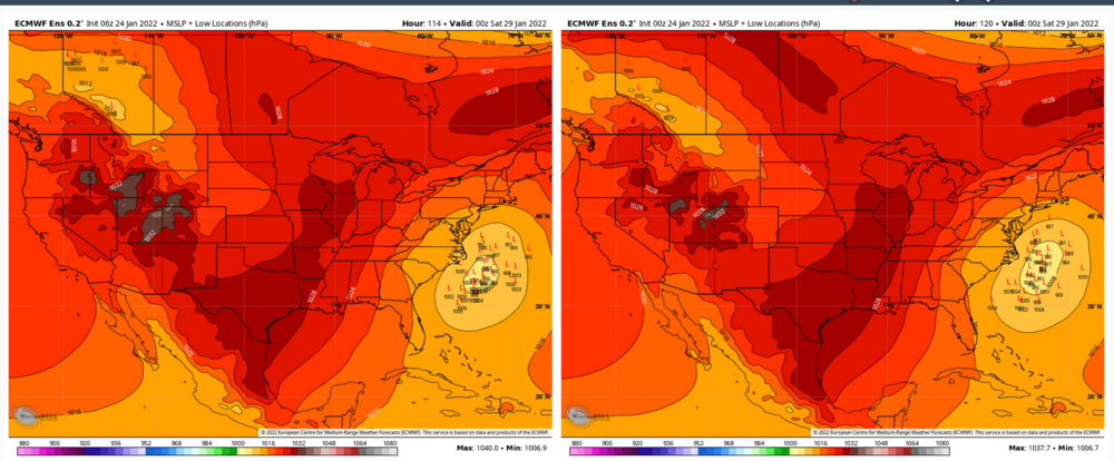
-
Late January and February Medium/Long Range Discussion
yoda replied to WinterWxLuvr's topic in Mid Atlantic
You're good Don't worry about it -
Late January and February Medium/Long Range Discussion
yoda replied to WinterWxLuvr's topic in Mid Atlantic
I was trying not to have like 6 huge images in one post if you are talking about mine. Give me a minute and I will rectify that -
Late January and February Medium/Long Range Discussion
yoda replied to WinterWxLuvr's topic in Mid Atlantic
Quick glance at the 06z EPS snow maps through 144 (reminder, there are 50 members): 17 give DCA at least 2" 9 give DCA at least 6" 6 give DCA at least 10" 1 mega hit approaching 2 feet- 4,130 replies
-
- 2
-
-
-
- prime climo
- cold canada
- (and 1 more)
-
Late January and February Medium/Long Range Discussion
yoda replied to WinterWxLuvr's topic in Mid Atlantic
- 4,130 replies
-
- 1
-
-
- prime climo
- cold canada
- (and 1 more)
-
Late January and February Medium/Long Range Discussion
yoda replied to WinterWxLuvr's topic in Mid Atlantic
yeah... that some big changes at h5 between 06z EPS at 120 and 00z EPS at 126 lol -
Late January and February Medium/Long Range Discussion
yoda replied to WinterWxLuvr's topic in Mid Atlantic
It would look like the 06z EPS came west some more -
Late January and February Medium/Long Range Discussion
yoda replied to WinterWxLuvr's topic in Mid Atlantic
06z EURO h5 at 90 00z EURO h5 at 96- 4,130 replies
-
- 2
-
-

-
- prime climo
- cold canada
- (and 1 more)
-
Late January and February Medium/Long Range Discussion
yoda replied to WinterWxLuvr's topic in Mid Atlantic
Waiting for the last frames of the 06z EURO... but can already tell the westward movement by hour 84 compared to 00z 90- 4,130 replies
-
- 1
-
-
- prime climo
- cold canada
- (and 1 more)
-
Apparently, in the zones, it says low around 10 at DCA
-
Late January and February Medium/Long Range Discussion
yoda replied to WinterWxLuvr's topic in Mid Atlantic
I'm guessing you want the h5 to move from the bigger circle to the smaller one in this image?- 4,130 replies
-
- 1
-
-
- prime climo
- cold canada
- (and 1 more)
-
Late January and February Medium/Long Range Discussion
yoda replied to WinterWxLuvr's topic in Mid Atlantic
You could see the Major changes coming by 96- 4,130 replies
-
- 3
-
-
- prime climo
- cold canada
- (and 1 more)
-
Late January and February Medium/Long Range Discussion
yoda replied to WinterWxLuvr's topic in Mid Atlantic
Major differences show up at h5 06z 132 compared to 00z 138- 4,130 replies
-
- 2
-
-
- prime climo
- cold canada
- (and 1 more)
-
Late January and February Medium/Long Range Discussion
yoda replied to WinterWxLuvr's topic in Mid Atlantic
06z GFS h5 looks a bit better and further west at 120 -
Late January and February Medium/Long Range Discussion
yoda replied to WinterWxLuvr's topic in Mid Atlantic
-
Late January and February Medium/Long Range Discussion
yoda replied to WinterWxLuvr's topic in Mid Atlantic
Ridge is a little bit wider and stronger out west on the 06z ICON at 114 compared to 00z at 120 -
Late January and February Medium/Long Range Discussion
yoda replied to WinterWxLuvr's topic in Mid Atlantic
FWIW- 4,130 replies
-
- 1
-
-
- prime climo
- cold canada
- (and 1 more)
-
Late January and February Medium/Long Range Discussion
yoda replied to WinterWxLuvr's topic in Mid Atlantic
The placement of the ridge at 144 is yes- 4,130 replies
-
- 1
-
-
- prime climo
- cold canada
- (and 1 more)
-
Late January and February Medium/Long Range Discussion
yoda replied to WinterWxLuvr's topic in Mid Atlantic
So 18z EPS at 144? -
I see unreadable threads in our future

