Dunkman
-
Posts
2,080 -
Joined
-
Last visited
Content Type
Profiles
Blogs
Forums
American Weather
Media Demo
Store
Gallery
Everything posted by Dunkman
-
Hard to get excited about the incoming flizzard when sitting at 1.5" for the winter so far. Need more than that here!
-
Who could have guessed that a SW wind would be bad for cad?
-
So I shouldn't say this but as soon as I saw reports of 6" from CHS the first thing I thought was how long has it been since Raleigh had 6" of snow? Was it this decade?
-
Beam height. It's not snowing anywhere near the surface to your west. The 0.5° scan is 3000 feet above the surface in Sanford, which is the closest location to the radar site that's actually showing a return.
-
So how about all those storms over the years that were supposed to jackpot the Triad and Triangle and miss SW VA only to have Roanoke jackpot every single time? Why can't that happen when I'm supposed to be too far NW? Just once? Jokes aside I'm pretty glad that I don't have to sweat this one out. Looks extra stressful even by NC winter storm standards.
-
There are a couple partly cloudy days in my 7 day forecast. I'm sure we can squeeze a few inches out of one of those...
-
The December to Remember 7th-8th blue turd winter threat thread.
Dunkman replied to lilj4425's topic in Southeastern States
Yeah it's killing me too. It isn't the warm ground though, it's not sticking to elevated surfaces either. The air is just too warm. -
The December to Remember 7th-8th blue turd winter threat thread.
Dunkman replied to lilj4425's topic in Southeastern States
I haven't had a chance to look at the HRRR in depth but one thing I noticed briefly flipping through the mesoscale models is that through 21z Friday it's fairly substantially drier than all of the other models. This is true pretty much everywhere but especially as you go N and W from the heaviest totals. -
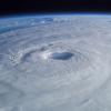
Most category 5 storms don't have the wind damage that Andrew did right at the core. I don't know if mesovortices have ever been proven as why Andrew's damage was so severe but it had something extra going on. I think I saw a tweet that Josh put this in his top 5 storms. I don't know the context of that tweet but he's definitely been in way more than 5 category 4-5 storms. edit to link tweet
-
I mean yeah they're pretty awful but the idea that Jose could dissipate more quickly isn't unreasonable. When Jose does dissipate however there isn't a lot of reason to think that the ridge will just suddenly build back in and shove Maria west. The Euro keeps Jose around for days longer than the GFS does and despite that Maria is actually closer to the coast on the Euro than the GFS before getting kicked out.
-
I think it makes sense to toss that one reading on the Rio Grande de Manati until proven otherwise. It doesn't match with the readings before and after at that gauge, upstream and downstream on that river, or to any of the rivers in the area. The COMP4 is more troubling because it isn't just one anomalous reading but it's at such an extraordinary level I'm not sure what to make of it.
-
No kidding. They've been working multiple storms for weeks now with no break.
-
Dropsonde a couple pages back is probably the most compelling evidence. Like 5 people posted it. Also were 152kt and 151kt unflagged SFMR on the 910mb pass.
-
So current heading based on NHC, recon, etc. is 300 degrees. Short term motion on radar honestly looks south of this. It's going to take a movement of 315 from the last recon fix to miss PR to the NE and something 310+ to clip the NE part of the country. Going right through the center of San Juan is 308.
-
Mine is already on upstairs. Trying to hold off downstairs but it's going to be close. Fab February?
-
You should always worry about sleet. I've had more sleet than snow the last 5 years. And I'm not talking liquid equivalent either. Actual ground measurements. 2 days ago I saw a model with snow at Disney World and now the NW Piedmont of NC is close enough to smell the sleet on the NAM. You're never safe!
-
Here's one from my run this morning. Perfect weather for me.