

Tatamy
-
Posts
2,585 -
Joined
-
Last visited
Content Type
Profiles
Blogs
Forums
American Weather
Media Demo
Store
Gallery
Everything posted by Tatamy
-
You had to be quite high or well north and west to get any accumulation. I passed through Bear Creek, PA on Tuesday 1931’ elevation and they had about 1” new OTG. In the Poconos you had to be above 1000’ to see a coating. Just goes to tell how difficult it has been to get snow on the ground so far this season.
-
Fair amount of interest out there on the models today for this one especially from the city on to the north and west. The CMC / Euro have this one along with 7 members of the GEFS. This is by no means anything overly significant however it is something to watch.
-
Steady light snow with visibility of about a mile. 35*
-
Not sure if anyone has looked at the 12z UKmet or the 12z Euro but both OP runs have bought into the system for Saturday hinted at by the ensembles earlier. Three members had it at 06z and 5 had it at 12z. The Euro has the event for next week for eastern NE as well.
-
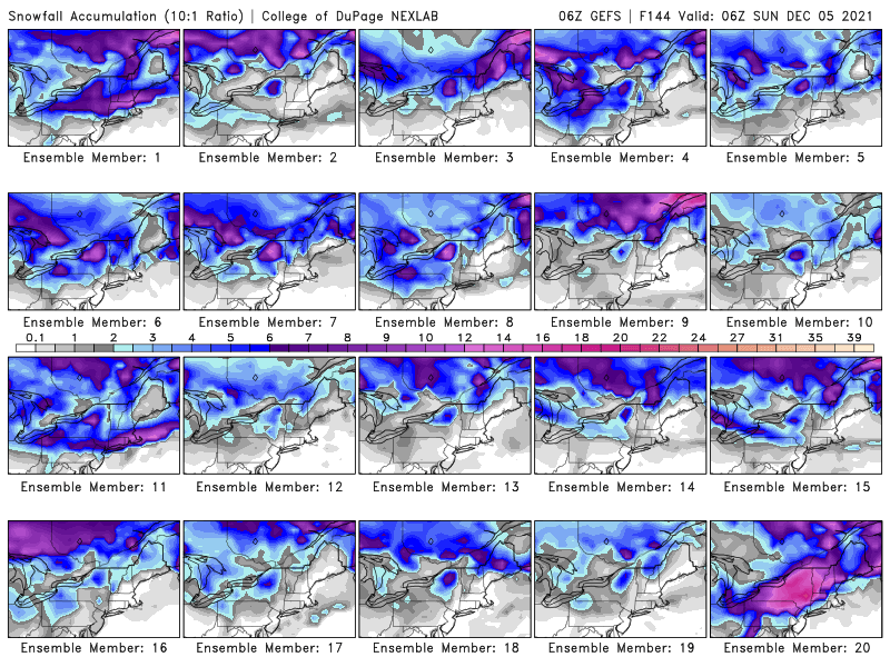
If you want to dig around in the models the 06z Ensemble run has 3 members that dig the short wave that is progged to pass across northern NE this weekend to a much greater degree than the mean.
-
06z Ensemble mean is not on board with this one https://weather.cod.edu/forecast/?parms=2021112906-GEFS-NE-winter-meansnacc-198-0-100
-
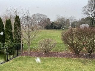
 Coating on colder surfaces here as well. 0.2” is the accum.
 -
December 2021 Obs/Disco...Dreaming of a White-Weenie Xmas
Tatamy replied to 40/70 Benchmark's topic in New England
12z GEFS snowfall mean would support the Euro idea of an inland runner for this time period. -
December 2021 Obs/Disco...Dreaming of a White-Weenie Xmas
Tatamy replied to 40/70 Benchmark's topic in New England
Sure is. 240 hrs on the 12z CMC and 252 hrs on the 12z GFS. Granted these are OP runs going out 10 days however the pattern is there. -
December 2021 Obs/Disco...Dreaming of a White-Weenie Xmas
Tatamy replied to 40/70 Benchmark's topic in New England
There is a site (or used to be) that shows the expected GEFS mean snowfall total. Does anyone have a link for it? -
It’s already here…
-
It’s about cloud cover and the wind speed. If the surface winds can decouple from the flow a few hundred feet up and go calm the bottom can drop out of the thermometer as shown. The cloud cover piece is self explanatory. I see similar events out here where on a cold morning lower spots (below 500 feet - approximately) can be colder than higher elevations due to being better able to decouple.
-
Tonight’s cold front has passed through here. I have light rain and the temperature is down to 51.
-
Every Friday night it seemed to snow. Don’t ever recall anything like that.
-
On the topic of snow it is snowing up in Mt. Pocono this evening with the trough swinging through. This is the second day in a row this has happened. This time it is actually accumulating on grassy areas.
-
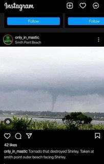
I came across this photo of the tornado that hit the Shirley area.
-
A station that I follow on WU in Cherry Grove recorded 54 mph at 3:29 pm SE Light on Block Island just reported a wind gust to 54 mph.
-
NWS Upton LSR's PRELIMINARY LOCAL STORM REPORT NATIONAL WEATHER SERVICE NEW YORK NY 441 PM EST SAT NOV 13 2021 ..TIME... ...EVENT... ...CITY LOCATION... ...LAT.LON... ..DATE... ....MAG.... ..COUNTY LOCATION..ST.. ...SOURCE.... ..REMARKS.. 0250 PM TSTM WND DMG 1 N LEVITTOWN 40.73N 73.52W 11/13/2021 NASSAU NY TRAINED SPOTTER DOWNED TREES AND WIRES NEAR TULIP LANE IN LEVITTOWN. PRELIMINARY LOCAL STORM REPORT NATIONAL WEATHER SERVICE NEW YORK NY 427 PM EST SAT NOV 13 2021 ..TIME... ...EVENT... ...CITY LOCATION... ...LAT.LON... ..DATE... ....MAG.... ..COUNTY LOCATION..ST.. ...SOURCE.... ..REMARKS.. 0320 PM TSTM WND DMG 1 S ISLIP TERRACE 40.74N 73.19W 11/13/2021 SUFFOLK NY AMATEUR RADIO MULTIPLE TREES AND WIRES DOWN, HOUSES WITH TREE DAMAGE, ROADS BLOCKED BY FALLEN TREES SOUTH OF MONTAUK HIGHWAY. PRELIMINARY LOCAL STORM REPORT NATIONAL WEATHER SERVICE NEW YORK NY 423 PM EST SAT NOV 13 2021 ..TIME... ...EVENT... ...CITY LOCATION... ...LAT.LON... ..DATE... ....MAG.... ..COUNTY LOCATION..ST.. ...SOURCE.... ..REMARKS.. 0344 PM TSTM WND DMG 1 ENE SHIRLEY AIRPORT 40.82N 72.86W 11/13/2021 SUFFOLK NY PUBLIC MULTIPLE TREES DOWN ON PONCHO DRIVE IN MASTIC. TREE ON POWERLINE. PRELIMINARY LOCAL STORM REPORT NATIONAL WEATHER SERVICE NEW YORK NY 419 PM EST SAT NOV 13 2021 ..TIME... ...EVENT... ...CITY LOCATION... ...LAT.LON... ..DATE... ....MAG.... ..COUNTY LOCATION..ST.. ...SOURCE.... ..REMARKS.. 0400 PM TSTM WND DMG 2 E REMSENBURG-SPEONK 40.81N 72.68W 11/13/2021 SUFFOLK NY NWS EMPLOYEE LARGE TREE DOWN ON ROAD. PRELIMINARY LOCAL STORM REPORT NATIONAL WEATHER SERVICE NEW YORK NY 410 PM EST SAT NOV 13 2021 ..TIME... ...EVENT... ...CITY LOCATION... ...LAT.LON... ..DATE... ....MAG.... ..COUNTY LOCATION..ST.. ...SOURCE.... ..REMARKS.. 0250 PM TSTM WND DMG LEVITTOWN 40.72N 73.51W 11/13/2021 NASSAU NY PUBLIC LARGE TREE DOWN ON HOUSE IN LEVITTOWN. PRELIMINARY LOCAL STORM REPORT NATIONAL WEATHER SERVICE NEW YORK NY 405 PM EST SAT NOV 13 2021 ..TIME... ...EVENT... ...CITY LOCATION... ...LAT.LON... ..DATE... ....MAG.... ..COUNTY LOCATION..ST.. ...SOURCE.... ..REMARKS.. 0250 PM TSTM WND DMG 1 WNW LEVITTOWN 40.73N 73.53W 11/13/2021 NASSAU NY PUBLIC LARGE TREE DOWN ON CAR ON HILLTOP ROAD IN LEVITTOWN. PRELIMINARY LOCAL STORM REPORT NATIONAL WEATHER SERVICE NEW YORK NY 402 PM EST SAT NOV 13 2021 ..TIME... ...EVENT... ...CITY LOCATION... ...LAT.LON... ..DATE... ....MAG.... ..COUNTY LOCATION..ST.. ...SOURCE.... ..REMARKS.. 0330 PM TSTM WND DMG EAST ISLIP 40.72N 73.18W 11/13/2021 SUFFOLK NY TRAINED SPOTTER LARGE BRANCHES, TREES, AND POWER LINES DOWN. PRELIMINARY LOCAL STORM REPORT NATIONAL WEATHER SERVICE NEW YORK NY 344 PM EST SAT NOV 13 2021 ..TIME... ...EVENT... ...CITY LOCATION... ...LAT.LON... ..DATE... ....MAG.... ..COUNTY LOCATION..ST.. ...SOURCE.... ..REMARKS.. 0310 PM MARINE TSTM WIND 15 S ATLANTIC BEACH 40.37N 73.70W 11/13/2021 M60 MPH ANZ355 NY BUOY NDBC BUOY 44065 MEASURED A WIND GUST OF 52 KNOTS. PRELIMINARY LOCAL STORM REPORT NATIONAL WEATHER SERVICE NEW YORK NY 326 PM EST SAT NOV 13 2021 ..TIME... ...EVENT... ...CITY LOCATION... ...LAT.LON... ..DATE... ....MAG.... ..COUNTY LOCATION..ST.. ...SOURCE.... ..REMARKS.. 0300 PM TSTM WND DMG 2 ENE BETHPAGE 40.76N 73.46W 11/13/2021 NASSAU NY PUBLIC LARGE TREE BRANCHES DOWN.
-
NWS Upton has reported the following wind gusts this afternoon at the Mesonet sites shown below: East Moriches 3:55pm 79 mph Mecox Bay 4:20pm 71 mph
-
Rain has changed to wet snow up in the Poconos as seen on a traffic camera near Mt. Pocono.
-
I was the same age but was in the NYC area during the run up to this event. My source of information was the Accuweather Mets on WINS. They spoke of a strong LP system that would be diving out of Alberta and would serve to generate an intense storm along the mid Atlantic coast. This discussion started on the Friday and Saturday before the event (Monday). This scenario was what was being generated on the models of that time. There seemed to be little doubt in their minds. The Mets I am referring to are Dr. Joel Myers, Dr. Joel Sobel, and Elliott Abrams. The only other event that I can recall that was forecasted that far in advance with that level of certainty was the Superstorm of 1993.
-
Low level inversion seems to be in place out here in eastern PA and NW NJ this morning. Low elevation locations are currently in the low to mid 30s while most other places are well into the 40s. This is resulting in 10 to 15 degree temperature differences across short distances.
-
Winds along the shore in most places never went down to calm to allow for radiational cooling. I have a station on Fire Island which never had winds go below 3-4mph and that resulted in temperatures staying in the 40s all night. Interestingly when I looked at WU there were stations almost within walking distance of the Great South Bay that did go calm and drop off to freezing.
-
Bottomed out at 26 out here.
-
My lettuce and parsley are still going strong. Everything else has been frosted out over the past two nights. I had some impatiens in pots that I had placed next to my foundation in order to see if I could keep them going. Last night’s frost got them. I have found that 24 degrees is the cutoff for what parsley will survive down to. I any case my lettuce and parsley are in flats that I can bring in if it gets that cold.

