

Tatamy
-
Posts
2,567 -
Joined
-
Last visited
Content Type
Profiles
Blogs
Forums
American Weather
Media Demo
Store
Gallery
Everything posted by Tatamy
-
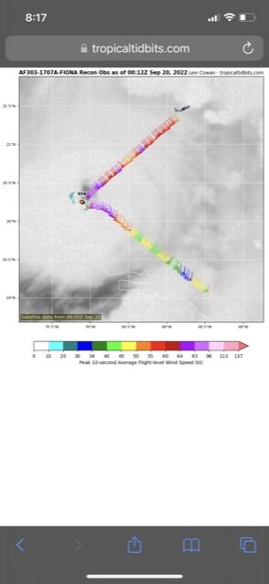
Recon is in the storm now and strongest surface winds have been measured ~ 65 - 70 kts. Strongest flight level winds have been measured at over 100 kts. Recon just flew to the south of Sable Island.
-
Environment Canada has a station there. Last report from an hour ago had winds of 37 knots with gusts to 47 knots.
-
Yup - 46 mph with a recent gust to 61 mph. Station is in a very exposed location as well.
-
Tropical Storm force wind gusts have now reached Cape Breton Island and eastern Nova Scotia. The highest wind gust I have seen so far is at Gabarus with a gust to 49 mph and a pressure of 29.12 inHg (Davis Network) Barometric pressure values close to this are common in that region at this time.
-
Regarding your statement about NYC not likely to get hit by a major hurricane, not true. In 1976 and 1985 Hurricanes Belle and Gloria made landfall on the south shore of Nassau County. Both were Cat 1’s. Belle at Jones Beach and Gloria further east towards Massapequa. If you can go down to Coney Island or any other beach and look out over the ocean then yes a hurricane and a major one at that can hit NYC or anywhere else in the region. Sandy has been described as a one in a 500 year storm and Fiona may end up in the same category. The fact that the east coast of North America has been hit by two such storms in ten years should be very concerning. You can argue that they were not “true” hurricanes however the cost of the damage caused by these speaks for itself. In any case if the right synoptic conditions present themselves then yes NYC can get hit by a Major hurricane.
- 1,529 replies
-
- 3
-

-
- hurricane
- tropical storm
- (and 1 more)
-
This is the Wreck Road station in Sandys Parish on Bermuda (Davis Network).
-
That’s not all of it. The station I have been following has been recording wind gusts over 80 mph since 6AM this morning local time. In fact during the 11AM hour the highest wind gust was 95 mph and during the 12PM hour they recorded a gust to 86 mph. Note that they are one hour ahead of us.
-
06z GFS. There have been a lot of statements made that Fiona will be post tropical when it reaches Nova Scotia. It appears that it will still have a relatively calm center at landfall. Note that these numbers are KPH.
-
Your eyes are not playing with you. Projected gusts on Sable Island are expected to reach 150 mph. Many places from Halifax and east are projected to see 80 - 100 mph gusts. This includes eastern Nova Scotia, Cape Breton Island, Prince Edward Island, and the SW coast of Newfoundland. The model is projecting efficient transfer of this wind energy to the surface.
-
06z Euro projected wind gusts for Fiona when it reaches Nova Scotia.
-
Strongest wind gust that I have found on the island so far has been a gust to 99 mph on the west end of the island. This has been measured within the past 10 minutes at a Davis station.
-
18z GFS
-
1 mph = 1.609344 kph The KPH number south of Nova Scotia would translate to 120 mph.
-
Incredible. A near 921 mb hurricane landfalling in Nova Scotia and 12 hours later it is still drifting in the area with a pressure of 942mb. This would be amazing if it hit Belize or another part of the Yucatán Peninsula. However it is coming ashore at 46N. No words.
-
06z Euro has the same scenario. Pressure at landfall is 935mb on the GFS and 928mb on the Euro.
-
06z GFS has the storm making landfall in eastern Nova Scotia / Cape Breton Island at 75 hours and basically parks it or moves very slowly in the vicinity for upwards of 12 - 15 hours. This is highly unusual in that in the majority of cases these storms rip through that area in 3 - 6 hours. This is going to lead to potential mass destruction in that region.
-
Expected pressure at landfall: 12z Euro is at 932mb 12z GFS is at 928mb 12z CMC is at 942mb These are all at 96 hours with the storm at Nova Scotia/ Cape Breton Island. Euro first saw this possibility early Saturday.
-
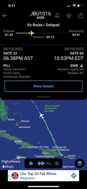
This is the status of the current recon flight. Looks like JBU1016 flew over the NE quadrant.
-
According to FlightAware this information is correct- they just flew over the hurricane.
-
It’s not just the track over the eastern part of the DR. The mountains over the central part of Hispaniola are upwards of 10000 feet in elevation. Air descending down the slopes of these mountains dries out and gets ingested into the circulations of these TC’s and inhibits reorganization and restrengthening. Not this time. Wow.
-
I have been tracking hurricanes since 1971. In that time period I have never seen a storm cross the full length of the DR and look like this only a few short hours later after emerging into the Atlantic. This is quite spectacular to watch unfold.
-
Fiona continues to move NW over the eastern DR.
-
Nova Scotia hits 0z Euro 0z CMC
-
0z Euro takes Fiona into Nova Scotia at 174 hrs. 937mb central pressure at that time with impacts spreading into Maine.
-
You are going to need a meridional flow pattern with a big east central deep US trough if you are looking for this to come up the coast. No ensemble support for this currently. As SnoSki 14 said this thing is likely gone once it passes through or even east of the Bahamas (assuming it crosses Hispaniola).

