Tatamy
-
Posts
2,581 -
Joined
-
Last visited
Content Type
Profiles
Blogs
Forums
American Weather
Media Demo
Store
Gallery
Everything posted by Tatamy
-
 This ties into the analysis on the 3K just posted by Bluewave.
 -
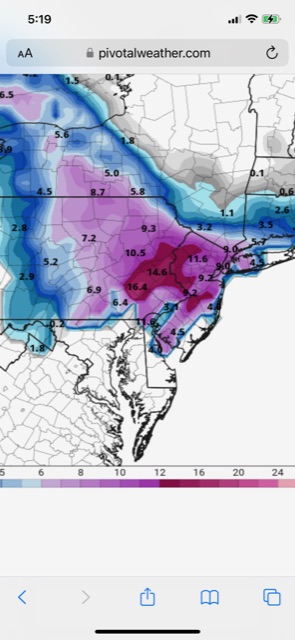
According to the 12z NAM it looks like the place to be for this event is LI Sound. Places along the north shore of Suffolk and the north fork would do good as well.
-
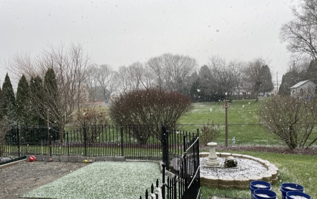
White rain
-
Nice burst of moderate snow passing through. 32•
-
Light wet snow falling here with a coating on colder surfaces.
-
If you are following this thread and have a weather station check your dew points. If they have increased in a short period of time this evening and your skies are now overcast check your conditions outside if you are along or north of I78. I am getting flurries here and I am seeing them reported on LI as well with the onshore flow.
-
Your R/S line for this event and others especially this time of year typically runs along LI Sound from east to west near the CT coast. You’re not the only one that gets to worry about R/S lines however. If you’re in NJ it’s typically along I80. In PA it’s Blue Mountain. In fact out here Blue Mountain is every bit the imposing geological barrier and guarantor of the R/S line as LI Sound is for you.
-
There is already a thread set up for the event for Sunday and Monday.
-
I was 2’ at 06z; ZIP at 12z; and now back to 15”. Gotta love this consistency.
-
The GEFS has been showing these hits for a few runs now. The problem has been with the OP.
-
I agree with Ant about the GFS in terms of consistency. As a PA guy I will take the 06z solution- knowing full well that there will be something totally different at 12z.
-
The 06z run with the IVT feature is certainly interesting to look at. The GEFS has been continuing to show the event even while the OP went AWOL.
-
What’s not to like about this morning’s 06z GFS / GEFS?
-
GEFS provides a much different story than the OP. Some big runs on some of the members for next week.
-
Look at the ensemble data.
-
GEFS 12z 162 hours GEFS 06z 168 hours
-
12z CMC with an intense tucked in solution for 12/16.
-
I saw that also. It does not get a lot of weight for this purpose however its solution is interesting.
-
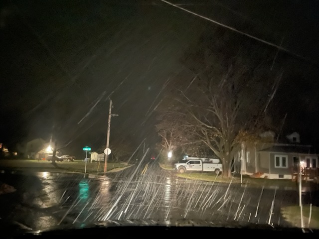
I actually went to chase this little event that night at a higher elevation and this is what I saw. I was convinced that I was not going to see anything at my place. It turned out that I didn’t have to. In any case it lasted less than 15 minutes.
-
Check out the MSLP and 10m AGL winds for the 06z GFS at 192 hours on Pivotal. This run has something for everyone. Hurricane force winds, 972 SLP - even a sting jet feature. Fortunately these features are off shore.
-
FWIW the 0z ensembles of the CMC are markedly colder than the OP in terms of precip type for the event later next week- especially inland.
-
06z GFS is an HECS. This one would produce blizzard conditions and hurricane force winds in the offshore waters. Big stuff on this run of the GFS.
-
The CMC is going with rain on the coast and ice inland for the event later next week. The Euro is rain for most with ice well inland for this one. The GFS seems to be on it’s own with the big snows.
-
A year before that it was the turn of the CMC to produce the gigaweenie maps for the 1/31/21 event. Many places in northern NJ and the other northern and western suburbs received 24-30” from that one.