nj2va
-
Posts
15,345 -
Joined
-
Last visited
Content Type
Profiles
Blogs
Forums
American Weather
Media Demo
Store
Gallery
Everything posted by nj2va
-

January 24-26: Miracle or Mirage JV/Banter Thread!
nj2va replied to SnowenOutThere's topic in Mid Atlantic
Sorry -
Jan 24-26 Weekend Snow and Sleetfest Model Thread Part Tres
nj2va replied to H2O's topic in Mid Atlantic
Wow, down to 22/3 here. -1/-6 at Deep Creek. -
January 24-26: Miracle or Mirage JV/Banter Thread!
nj2va replied to SnowenOutThere's topic in Mid Atlantic
Usually you’re the curse when you’re out there for your Wisp weekend, it’s 45 and rain. Glad your mojo has improved -
January 24-26: Miracle or Mirage JV/Banter Thread!
nj2va replied to SnowenOutThere's topic in Mid Atlantic
Let’s do this! Tommy will have a goal this period, calling it now -
January 24-26: Miracle or Mirage JV/Banter Thread!
nj2va replied to SnowenOutThere's topic in Mid Atlantic
I prefer to stay out of them b/c of the bitching and moaning about back-end, flip to mix, etc. Good call.. -
Jan 24-26 Weekend Snow and Sleetfest Model Thread Part Tres
nj2va replied to H2O's topic in Mid Atlantic
Looking at soundings, DC flips around 16 or 17z Sunday on the GFS, which is pretty close to the Euro. GFS QPF is ~0.8” so a really nice thump. -
January 24-26: Miracle or Mirage JV/Banter Thread!
nj2va replied to SnowenOutThere's topic in Mid Atlantic
Should I tag you in my obs when I first flip to sleet? -
January 24-26: Miracle or Mirage JV/Banter Thread!
nj2va replied to SnowenOutThere's topic in Mid Atlantic
Caps have had a banger of a 2nd period. Just owning the ice right now. -
Jan 24-26 Weekend Snow and Sleetfest Model Thread Part Tres
nj2va replied to H2O's topic in Mid Atlantic
If both NAMs are stubbornly showing that earlier flip than Euro/others tomorrow, I’ll definitely start to take it more seriously. I also want to check tomorrow morning how NAM has done in the south with the storm. -
Jan 24-26 Weekend Snow and Sleetfest Model Thread Part Tres
nj2va replied to H2O's topic in Mid Atlantic
It’s been a long time since the whole area has been under a WSW -
Jan 24-26 Weekend Snow and Sleetfest Model Thread Part Tres
nj2va replied to H2O's topic in Mid Atlantic
Yeah it was a touch better for us. At this point, I don’t think we’re going to see huge changes but 25-50 miles or 1-2 extra hours before sleet can mean 2-4” more of snow. -
January 24-26: Miracle or Mirage JV/Banter Thread!
nj2va replied to SnowenOutThere's topic in Mid Atlantic
Let’s go Caps! -
Jan 24-26 Weekend Snow and Sleetfest Model Thread Part Tres
nj2va replied to H2O's topic in Mid Atlantic
I’m kinda excited for a sleet bomb after snow. We’re going to be a glacier. Down to 27 here. 1/-3 at Deep Creek! -
Jan 24-26 Weekend Snow and Sleetfest Model Thread Part Tres
nj2va replied to H2O's topic in Mid Atlantic
Looks like maybe 0.4/0.5” QPF before the flip? -
Jan 24-26 Weekend Snow and Sleetfest Model Thread Part Tres
nj2va replied to H2O's topic in Mid Atlantic
Starting at 6z/12z tomorrow, its hard to completely discount the NAMs, especially the 3K thermals. -
Jan 24-26 Weekend Snow and Sleetfest Model Thread Part Tres
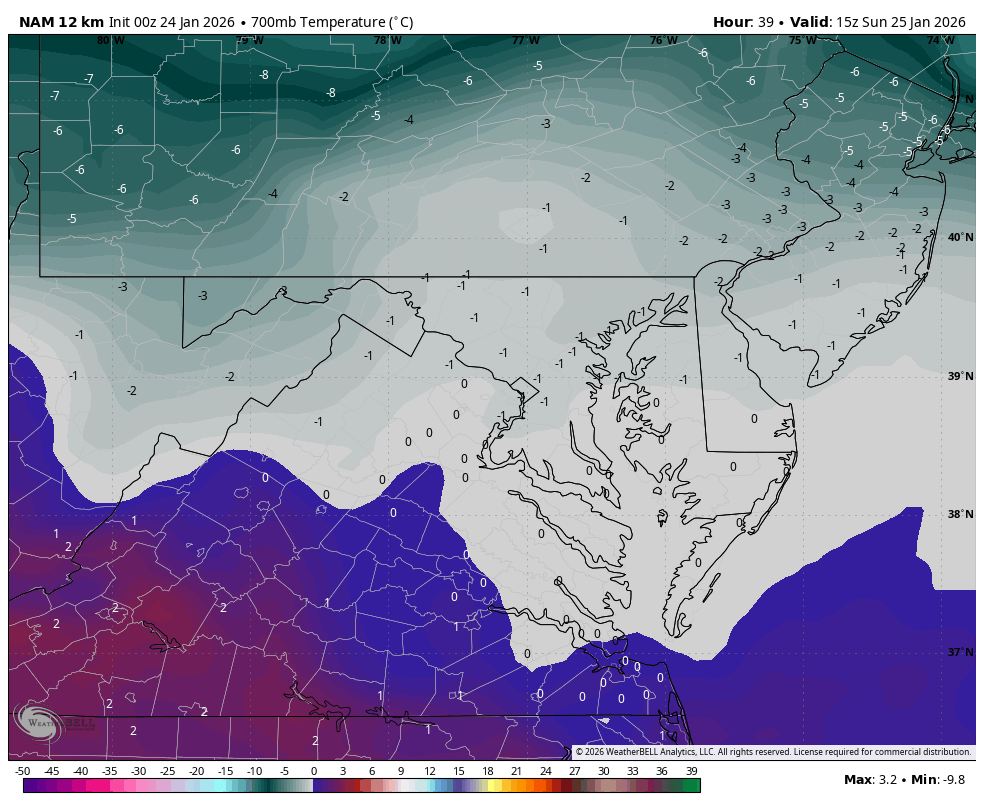
nj2va replied to H2O's topic in Mid Atlantic
15z on the 12k NAM at 700
-
January 24-26: Miracle or Mirage JV/Banter Thread!
nj2va replied to SnowenOutThere's topic in Mid Atlantic
Alexandria, I think it’ll be fun with the snow/sleet and freezing rain (to end). If McHenry was getting 2-3’, I would have chased. -
Jan 24-26 Weekend Snow and Sleetfest Model Thread Part Tres
nj2va replied to H2O's topic in Mid Atlantic
48H HRRR is better off being in the banter. -
January 24-26: Miracle or Mirage JV/Banter Thread!
nj2va replied to SnowenOutThere's topic in Mid Atlantic
I don’t know, I’m totally out on this storm until I know if Jenkins is back in. -
Jan 24-26 Weekend Snow and Sleetfest Model Thread Part Tres
nj2va replied to H2O's topic in Mid Atlantic
Temp dropping like a rock, down to 34/10. 5/0 at Deep Creek. -
January 24-26: Miracle or Mirage JV/Banter Thread!
nj2va replied to SnowenOutThere's topic in Mid Atlantic
Sorry, I forgot to respond last night…I don’t think it’s the greatest upslope setup with the departing storm track but certainly will have snow showers on Monday. -
January 24-26: Miracle or Mirage JV/Banter Thread!
nj2va replied to SnowenOutThere's topic in Mid Atlantic
Martini for happy hour - we got a snowstorm coming y’all! -
Jan 24-26 Weekend Snow and Sleetfest Model Thread Part Tres
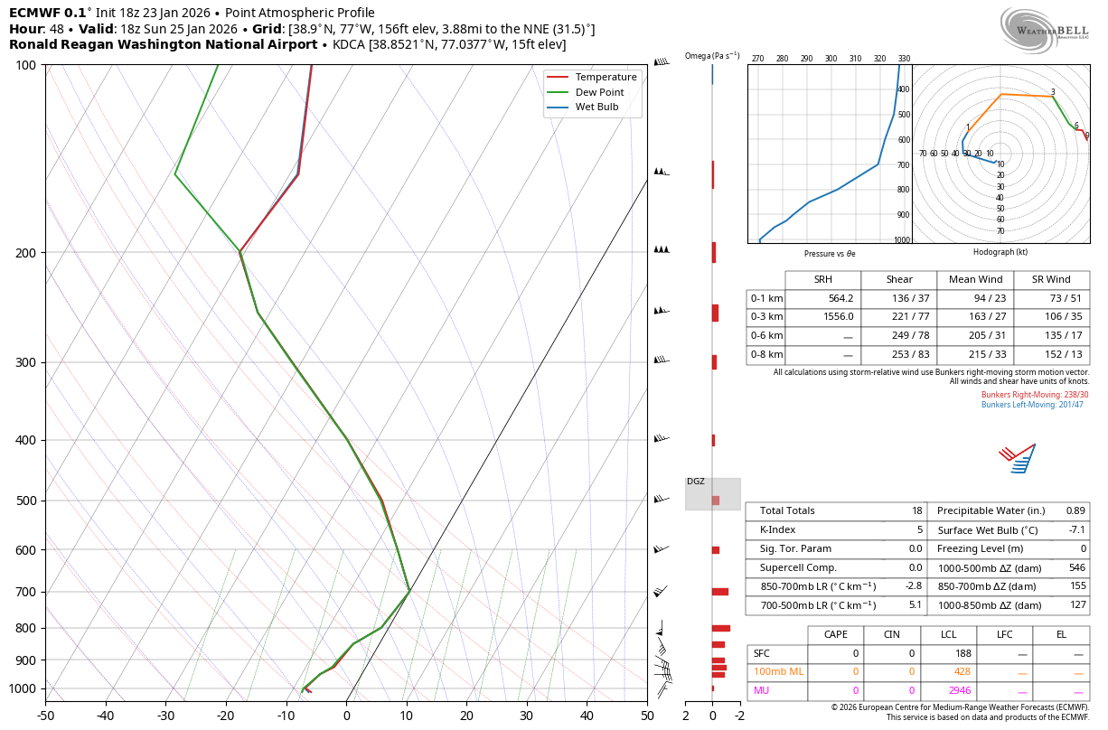
nj2va replied to H2O's topic in Mid Atlantic
That was a fantastic run for us. We hold until 18z with about 0.9” QPF by then. Here’s 18z at DCA. To me, this does look like freezing rain at 00z Monday but someone much smarter could correct me.
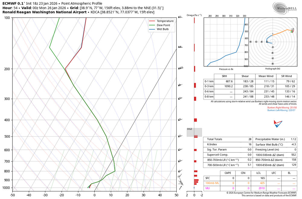
-
Jan 24-26 Weekend Snow and Sleetfest Model Thread Part Tres
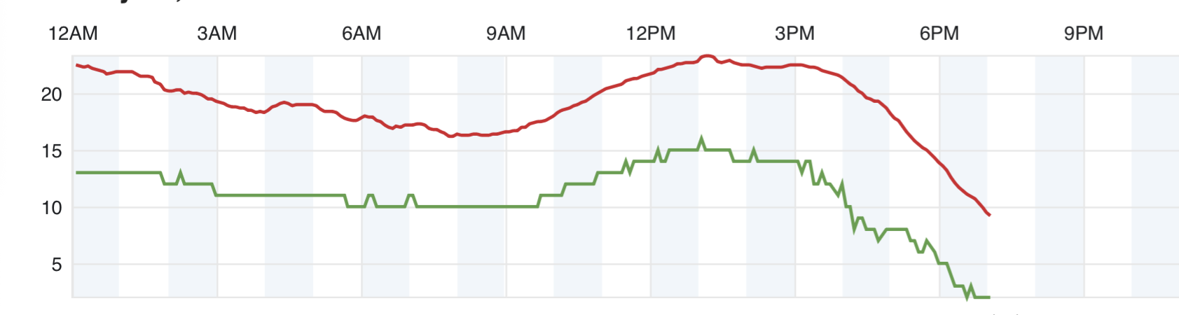
nj2va replied to H2O's topic in Mid Atlantic
For sure, here’s our Deep Creek temp. Down to 8 degrees.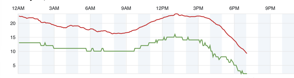
-
We leave for vacation on the 31st…tragic