mattskiva
-
Posts
498 -
Joined
-
Last visited
Content Type
Profiles
Blogs
Forums
American Weather
Media Demo
Store
Gallery
Everything posted by mattskiva
-
Under 50 dbz echoes now, good lightning show
-
Yeah that's the one. I wonder how much consideration is given to not setting off 5 million cell phones and waking up a whole metro area with EAS activation at 2am.
-
Left storm (is that kind of like left shark?) heading straight at me, about 15mi away. Tons of thunder and distant lightning now
-
Looks like maybe a hook in the SW portion of that cell now
-

2021 Mid-Atlantic Severe Weather - General Discussion
mattskiva replied to Kmlwx's topic in Mid Atlantic
There was a brief period of hail as it moved in (small hail). Lasted only about 3 minutes. Then garden variety thunderstorm, nothing exciting. -
2021 Mid-Atlantic Severe Weather - General Discussion
mattskiva replied to Kmlwx's topic in Mid Atlantic
Under the leading edge of that cell now - getting hail and lightning -
Excellent - I am down at our place at Colonial Beach this week and that track would seem to put the center of the storm pretty much right over top of us. That's a good bit west of the latest NHC track, though.
-
2021 Mid-Atlantic Severe Weather - General Discussion
mattskiva replied to Kmlwx's topic in Mid Atlantic
1" hail in SE loudoun area https://share.icloud.com/photos/0zy9Q0mb6wdf5m_evGzGqSApg#Chantilly_-_Cedar_Crest -
Waterspout here in Colonial Beach. Someone else caught it on video. Came right over our house, bent trees sideways and blew my storm door off its hinges. https://www.facebook.com/901050326645440/posts/3906459429437833/?vh=e&extid=0
-
I was in Carroll County, and I don't remember how much we got, but it was a lot.
-
Feb Long Range Discussion (Day 3 and beyond) - MERGED
mattskiva replied to WinterWxLuvr's topic in Mid Atlantic
Second this. I've been in NoVA for 30 years and Loudoun has historically done better than Philly. Not so much NW of Philly, that would be more like Winchester, but certainly better than downtown. -
Feb Long Range Discussion (Day 3 and beyond) - MERGED
mattskiva replied to WinterWxLuvr's topic in Mid Atlantic
IAD is really at 11.1? Doesn't feel like it here, and I am not far away. Winchester to psuhoffman may be doing well this year, but usually that line is more Manassas to Westminster. It seems like the line of non-suckage is more further NW than in normal years. -
Climo always wins
-
Pouring snow here in eastern Loudoun about 1.5" so far. This reminds me a lot of the borderline temps and rates of the Snowquester storm of a few years back - yes I know a sore spot for many, we got 8" while it was all rain 15 miles east.. The heavy wet nature of thr storm so far is very similar.
-
Feb Long Range Discussion (Day 3 and beyond) - MERGED
mattskiva replied to WinterWxLuvr's topic in Mid Atlantic
Maybe on the coastal plain, but it was well below that on the Allegheny Plateau about 3-4 years ago. I was on a trip with family in Canaan Valley and it was subzero highs (I think -6 one day, -8 the other) on a Sat & Sun in Feb. -
Jan 31st - 33rd Storm Obs and Disco like it's 1979
mattskiva replied to Bob Chill's topic in Mid Atlantic
14" so far here in Canaan Valley - based on forecasts, could get close to 20" by Wed. So much for the 3-6" forecast as of Sun AM. -
I can live with that Leesburg total. Was hoping for 20+ but I will survive.
-
DC always mixes during the big ones. And by always I don't mean usually, I mean nearly 100 percent of the time. Places like Loudoun, Frederick/Carroll do best often when DC mixes.
-
How much of this is from the frontend vs. coastal? Doesn't seem to imply as strong of a coastal as some of the earlier solutions.
-
So they're just forecasting based on the WAA, and they think that will last until Monday afternoon there?
-
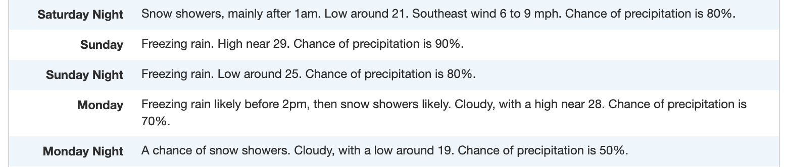
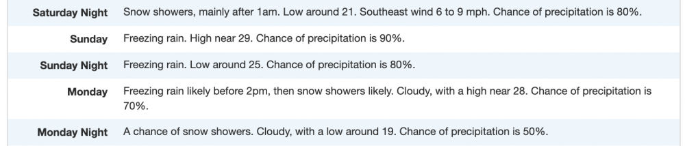
So, I know it's early and they will likely change this forecast, but what model is NWS PIT hugging in putting out this local forecast for Tucker County? Sure doesn't seem like any of them we've been discussing today -- unless there is a warm layer there that I'm missing.
-
Northern VA fringed. Fortunately it's a trash model and will be wrong.
-
I would literally pay for a forum where only the mets could post - even though it would mean I couldn't post. The amount of bad analysis from non mets is ... well, I was going to say stunning, but probably more accurate to say 'typical'.
-
Completely understandable. Also understand why @clskinsfan doesn't like a 2009-10 analog. That said, those of us out near Dulles strongly favor the suppressed solution . It's been five years since the last "big one" here -- and the setup is very similar to some of our historic storms. There is always some risk, but we are about 72 hours out and still have a coastal on the table -- it's been a while since we were this close.
-
Loudoun always does well compared to 90% of the sub - but you knew that