-
Posts
7,596 -
Joined
-
Last visited
Content Type
Profiles
Blogs
Forums
American Weather
Media Demo
Store
Gallery
Everything posted by ChescoWx
-

E PA/NJ/DE Winter 2023-2024 OBS/Discussion
ChescoWx replied to The Iceman's topic in Philadelphia Region
A cloudy but mild weekend with today being the warmest day for quite a while - in fact while today will soar well into the 50's we may very well not see a 50 degree or warmer day until we get to March. There is a slight chance of showers today but the main storm on the horizon arrives on Monday night. We should see rain possibly changing to wet snow from NW to SE toward Tuesday morning. Records for today: High 62 (1960) / Low 13 below (1899) / Precipitation 2.28" (2010) / Snow 22.8" (2010) - this was day 2 of our 6th largest snowstorm in County history with the 26.8" of snow that fell. -

E PA/NJ/DE Winter 2023-2024 OBS/Discussion
ChescoWx replied to The Iceman's topic in Philadelphia Region
-

E PA/NJ/DE Winter 2023-2024 OBS/Discussion
ChescoWx replied to The Iceman's topic in Philadelphia Region
I am a big Bernie Rayno fan...he just said he is going against the current Accu Weather snow maps and believes there will be no snow at all in SE PA nada too warm. Says models will indeed come north this weekend and AccuWeather and others will shift their accumulating snow forecasts northbound. -
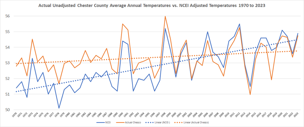
To show how significantly the post observation adjustments skew the warming trends. Take a look below at the actual average Chester County PA average annual temperatures (orange) vs. the NCEI adjusted averages (blue). Keep in mind NCEI continued to apply downward average temperature adjustments to the actual averages each and every year for the first 35 consecutive years on this graph between 1970 and 2004. The actual true warming of Chester County PA (orange) has clearly been very modest and not alarming at all since 1970. However if we apply the NCEI adjustments look how much greater the warming trend line becomes.... well alarming.
-

E PA/NJ/DE Winter 2023-2024 OBS/Discussion
ChescoWx replied to The Iceman's topic in Philadelphia Region
-

E PA/NJ/DE Winter 2023-2024 OBS/Discussion
ChescoWx replied to The Iceman's topic in Philadelphia Region
Spots over 600 ft asl will accumulate....if there is snow falling that is -

E PA/NJ/DE Winter 2023-2024 OBS/Discussion
ChescoWx replied to The Iceman's topic in Philadelphia Region
-

E PA/NJ/DE Winter 2023-2024 OBS/Discussion
ChescoWx replied to The Iceman's topic in Philadelphia Region
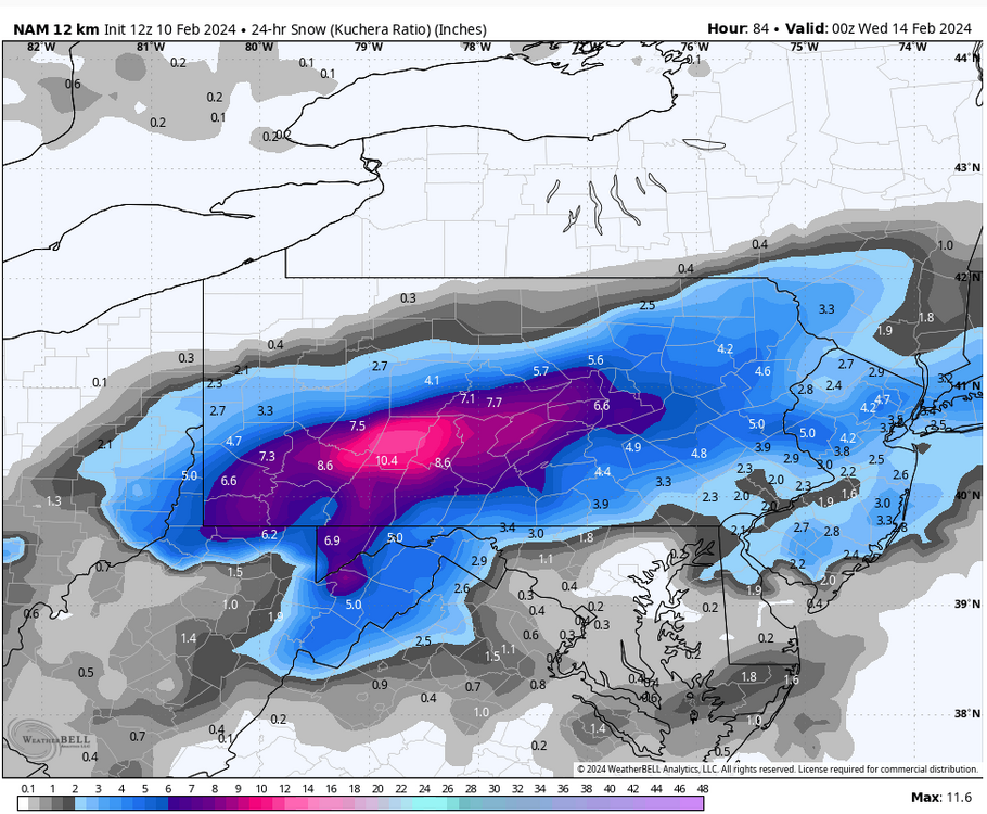
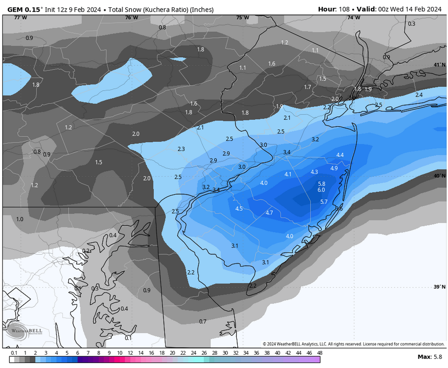
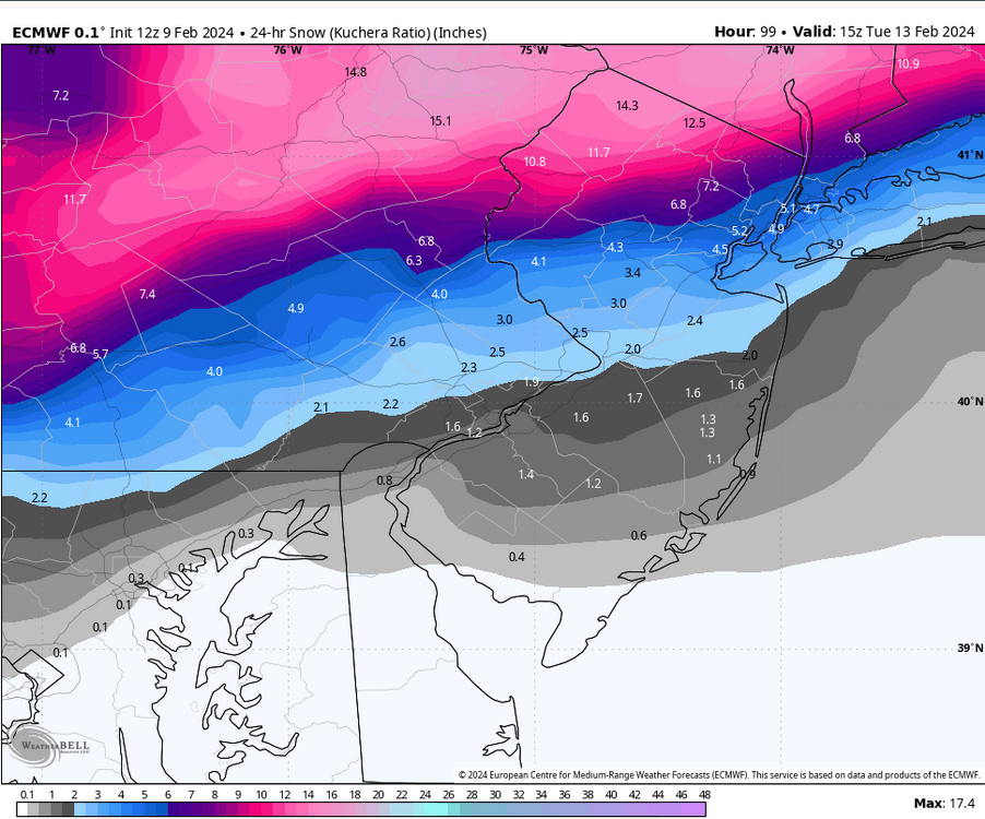
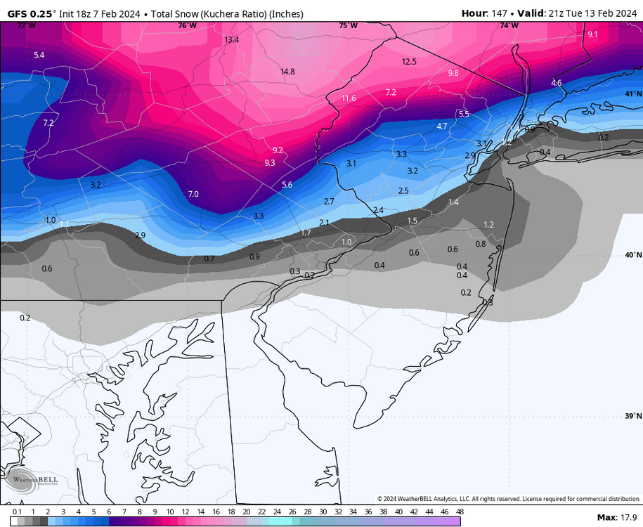
Through 1pm Tuesday the Euro has 2" at KMQS to 7" at KABE -

E PA/NJ/DE Winter 2023-2024 OBS/Discussion
ChescoWx replied to The Iceman's topic in Philadelphia Region
Early spring incoming! -

E PA/NJ/DE Winter 2023-2024 OBS/Discussion
ChescoWx replied to The Iceman's topic in Philadelphia Region
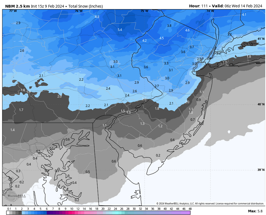
The NBM with it's nice blend has done IMHO the best job with storms so far this season...If I were in the Lehigh Valley and on northbound from there I would be pretty optimistic about snow. Down in southern climes like where I am....not so much. -

E PA/NJ/DE Winter 2023-2024 OBS/Discussion
ChescoWx replied to The Iceman's topic in Philadelphia Region
No doubt you've all missed the one and only fabulous WXSIM (now featuring the Euro model blended in) forecast. WXSIM text forecast for East Nantmeal, initialized at 9:00 AM Feb 9, 2024 Monday night: Mostly cloudy to cloudy in the evening, becoming dense overcast after midnight. Rain likely after midnight. Low 34. Wind east-northeast around 2 mph in the evening, becoming 7 mph, gusting to 18 mph, after midnight. Chance of precipitation 60 percent. Precipitation mostly less than a quarter of an inch. Tuesday: Dense overcast. A mix of snow, rain, and sleet likely in the morning, then a chance of a mix of snow and rain in the afternoon. High 37. Wind chill ranging from 25 to 31. Wind east-northeast around 10 mph, gusting to 19 mph, in the morning, becoming north-northeast in the afternoon. Chance of precipitation 80 percent. Precipitation (liquid equivalent) mostly between 1 and 2 inches. Snow or ice (on ground) accumulation 3 to 5 inches. -

E PA/NJ/DE Winter 2023-2024 OBS/Discussion
ChescoWx replied to The Iceman's topic in Philadelphia Region
-
Okie name just 1 event that has never happened before?? all the above have always happened in history....
-
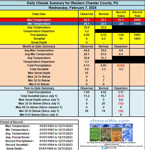
A couple more very warm days for February on tap today and tomorrow before we begin to cool a bit on Sunday and much chill back to average cold for next week. We could be close but will likely fall just shy of records for high temps both today and tomorrow. Record today is 61 back in 1990 and 62 tomorrow set back in 1960. A slight chance of showers tomorrow but a better shot of rain arriving on Monday with a possible turn to snow into Tuesday morning. Records for today: High 61 (1990) / Low 14 below zero (1934) / Precipitation 1.86" (1906) / Snow 6.0" (1936)
-

E PA/NJ/DE Winter 2023-2024 OBS/Discussion
ChescoWx replied to The Iceman's topic in Philadelphia Region
A couple more very warm days for February on tap today and tomorrow before we begin to cool a bit on Sunday and much chill back to average cold for next week. We could be close but will likely fall just shy of records for high temps both today and tomorrow. Record today is 61 back in 1990 and 62 tomorrow set back in 1960. A slight chance of showers tomorrow but a better shot of rain arriving on Monday with a possible turn to snow into Tuesday morning. Records for today: High 61 (1990) / Low 14 below zero (1934) / Precipitation 1.86" (1906) / Snow 6.0" (1936) -
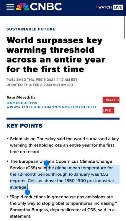
CNBC reports that “ The world surpasses key warming threshold [+1.5°C] across an entire year for the first time!!! Ruh roh...let's all tremble in our boots.... but of course with that threshold crossed it not surprisingly delivered absolutely nothing catastrophic or life threatening to our planet. Now we used to hear that +1.5°C above the 1850-1900 pre-industrial average temps would be the scary “tipping point.” Me thinks the climate alarmists will need to push that baby back to maybe +2.0°C or surely 2.1 °C. That cataclysmic "tipping point" will most surely happen at that point.....right????
-
45th street
-

E PA/NJ/DE Winter 2023-2024 OBS/Discussion
ChescoWx replied to The Iceman's topic in Philadelphia Region
Hence why I leave forecasting to professionals like you!!! -
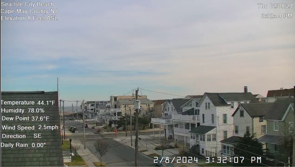
Chilly water temp 42 degrees down the shore keeping the beaches in Sea Isle City at 44 degrees....while inland in here in Western Chesco we are at 51 degrees
-

E PA/NJ/DE Winter 2023-2024 OBS/Discussion
ChescoWx replied to The Iceman's topic in Philadelphia Region
Chilly water temp 42 degrees down the shore keeping the beaches in Sea Isle City at 44 degrees....while inland in Chesco we are at 51 degrees -
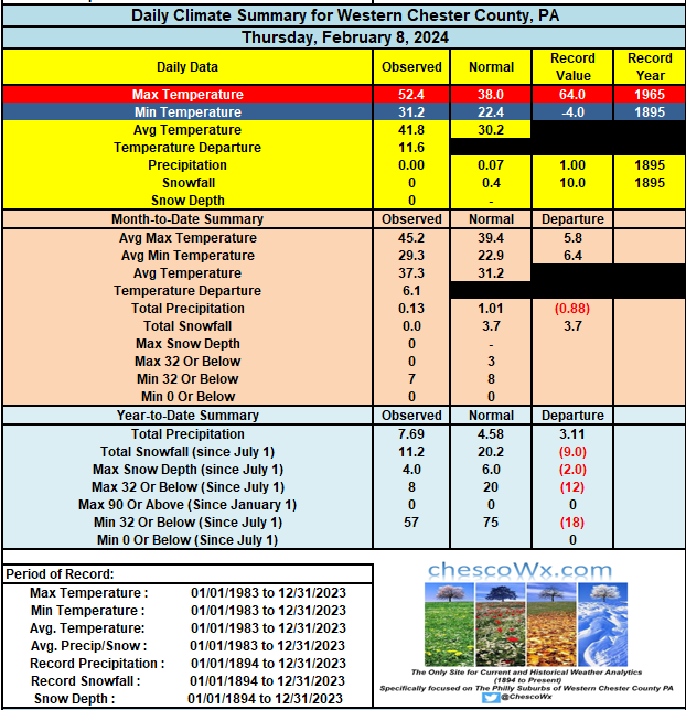
A few more beautiful mild February days on the way before the pattern changes to a more typical winter pattern next week. There is a chance some valley spots in the county could see near 60 degrees on Saturday. Rain looks to arrive on Monday night and if some models are to be believed could mix with or change to some wet snow toward Tuesday morning. Some models have multiple potential winter events over the next couple weeks so stay tuned. Records for today: High 64 (1965) / Low 4 below (1895) / Precip 1.00" (1895) / Snow 10.0" (1895)
-

E PA/NJ/DE Winter 2023-2024 OBS/Discussion
ChescoWx replied to The Iceman's topic in Philadelphia Region
A few more beautiful mild February days on the way before the pattern changes to a more typical winter pattern next week. There is a chance some valley spots in the county could see near 60 degrees on Saturday. Rain looks to arrive on Monday night and if some models are to be believed could mix with or change to some wet snow toward Tuesday morning. Some models have multiple potential winter events over the next couple weeks so stay tuned. Records for today: High 64 (1965) / Low 4 below (1895) / Precip 1.00" (1895) / Snow 10.0" (1895) -

E PA/NJ/DE Winter 2023-2024 OBS/Discussion
ChescoWx replied to The Iceman's topic in Philadelphia Region
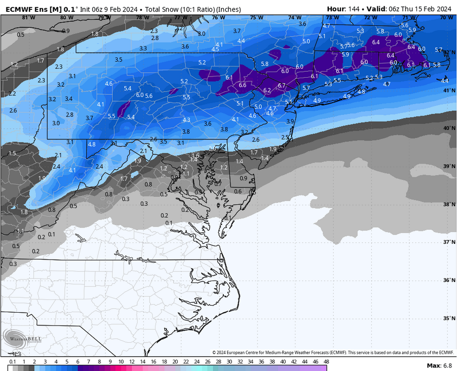
As others have said a long way to go...plus with all of the moving pieces like the upper level lows still being off in the pacific....as Bernie Rayno says - windshield wiper effect for the next few days. Expect the GFS to go way north at 12z and then the Euro to come south....neither of course will be validation. All in all an active pattern but not one that is sure to deliver snow. -

E PA/NJ/DE Winter 2023-2024 OBS/Discussion
ChescoWx replied to The Iceman's topic in Philadelphia Region
-
Thanks bdgwx! I promise to keep only to the actual pure un-adjusted National Weather Service Cooperative observers factual data and nothing else!! count on it!!

