north pgh
-
Posts
3,012 -
Joined
-
Last visited
Content Type
Profiles
Blogs
Forums
American Weather
Media Demo
Store
Gallery
Everything posted by north pgh
-

Pittsburgh/Western PA WINTER ‘25/‘26
north pgh replied to Burghblizz's topic in Upstate New York/Pennsylvania
Snowing moderately in Ross. Have to head downtown tonight. It should be an interesting drive home tonight around 10:00 ☃️ -
Pittsburgh PA Fall 2025 Thread
north pgh replied to TheClimateChanger's topic in Upstate New York/Pennsylvania
Yes 2-4, 3-5 looking more likely. It will be nice to have some decent snow on the ground early this winter for a change, So sorry about your pup. It’s never easy losing them. -
.20 in a downpour this morning. Hope to get a little more with the front this afternoon.
-
48 this morning at my house.
-
I haven't posted in a while. I lost power for 4 days from the storm. Looking forward to some drier weather this weekend.
-
Pittsburgh/Western PA Winter 2024-2025 Thread
north pgh replied to Rd9108's topic in Upstate New York/Pennsylvania
Getting moderate to heavy snow currently. Visibility is down to 1/2 mile. Big wet flakes. 1/2 inch on the ground. Over performing here but I am at a higher elevation. Roads are wet. -
Bust of storms today. I got some winds last hour over 40 mph. My temp went from 56 last hour to 47 now.
-
Pittsburgh/Western PA Winter 2024-2025 Thread
north pgh replied to Rd9108's topic in Upstate New York/Pennsylvania
Pouring rain with mixed snowflakes. Lightning and thunder. Winds gusting to maybe 30 mph. -
Pittsburgh/Western PA Winter 2024-2025 Thread
north pgh replied to Rd9108's topic in Upstate New York/Pennsylvania
Line about to move into Allegheny County. Any reports yet? -
Pittsburgh/Western PA Winter 2024-2025 Thread
north pgh replied to Rd9108's topic in Upstate New York/Pennsylvania
I picked up 1 inch yesterday and another inch early this morning. I think NWS Pittsburgh has done a poor job with these overnight snow showers lately. My daughter had to drive to the airport at 5 this morning and I told her the roads should be fine. They said Snow was tapering off to flurries last night but things got going again this morning. I know it’s not easy but it seems the inch or less forecast comes out after an inch falls in these little events. -
Pittsburgh/Western PA Winter 2024-2025 Thread
north pgh replied to Rd9108's topic in Upstate New York/Pennsylvania
Weird weekend. 2.5 inches Saturday morning. It all melts by Sunday morning. Today I pick up 3 inches. Some drifting with gusty winds. Not bad for a weekend. Nice overperformer with most coming in daylight hours. -
Pittsburgh/Western PA Winter 2024-2025 Thread
north pgh replied to Rd9108's topic in Upstate New York/Pennsylvania
Here also. Big fluffy flakes. -
Pittsburgh/Western PA Winter 2024-2025 Thread
north pgh replied to Rd9108's topic in Upstate New York/Pennsylvania
Temperature dropped to 27 and blowing snow and slush freezing up. I just had a wind gust over 45 and blew over both garbage cans. -
Pittsburgh/Western PA Winter 2024-2025 Thread
north pgh replied to Rd9108's topic in Upstate New York/Pennsylvania
NAM scored this morning’s thump. -
Pittsburgh/Western PA Winter 2024-2025 Thread
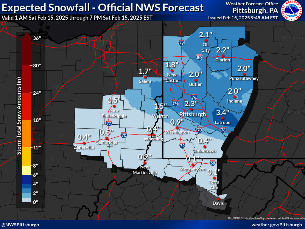
north pgh replied to Rd9108's topic in Upstate New York/Pennsylvania

-
Pittsburgh/Western PA Winter 2024-2025 Thread
north pgh replied to Rd9108's topic in Upstate New York/Pennsylvania
About an inch here too. Still coming down moderate to heavy. -
Pittsburgh/Western PA Winter 2024-2025 Thread
north pgh replied to Rd9108's topic in Upstate New York/Pennsylvania
Am I the only one awake? Pouring snow -
Pittsburgh/Western PA Winter 2024-2025 Thread
north pgh replied to Rd9108's topic in Upstate New York/Pennsylvania
Hoping for a good front end thump tomorrow morning. -
Pittsburgh/Western PA Winter 2024-2025 Thread
north pgh replied to Rd9108's topic in Upstate New York/Pennsylvania
Lightning and thunder banging today! If we’re not getting snow I’ll take some thunderstorms -
Pittsburgh/Western PA Winter 2024-2025 Thread
north pgh replied to Rd9108's topic in Upstate New York/Pennsylvania
Thunder today? -
Pittsburgh/Western PA Winter 2024-2025 Thread
north pgh replied to Rd9108's topic in Upstate New York/Pennsylvania
Thunderstorm tonight? -
Pittsburgh/Western PA Winter 2024-2025 Thread
north pgh replied to Rd9108's topic in Upstate New York/Pennsylvania
My temp is down to 4.8 and the skies are clear. I'm thinking about -8 -
Pittsburgh/Western PA Winter 2024-2025 Thread
north pgh replied to Rd9108's topic in Upstate New York/Pennsylvania
My temp is down to 4. -
Pittsburgh/Western PA Winter 2024-2025 Thread
north pgh replied to Rd9108's topic in Upstate New York/Pennsylvania
Yes I shoveled and salted my driveway last night so I could get up the hill this morning. I woke up to it snow covered and had to shovel again All in all I picked up 1/2 inch of snow during the day from the first batch, 1 inch last night and another 1 inch overnight. Currently 9 and bitter with the biting wind. -
Pittsburgh/Western PA Winter 2024-2025 Thread
north pgh replied to Rd9108's topic in Upstate New York/Pennsylvania
Snowing hard here. Not really a squall. Not much wind but big fluffy flakes. 1/2 mile visibility and accumulating.