north pgh
-
Posts
3,012 -
Joined
-
Last visited
Content Type
Profiles
Blogs
Forums
American Weather
Media Demo
Store
Gallery
Everything posted by north pgh
-

Pittsburgh/Western PA WINTER ‘25/‘26
north pgh replied to Burghblizz's topic in Upstate New York/Pennsylvania
I’m off to bed because I have to work at 4:00 am. I shoveled 4 times and salted so I should be able to make it up the driveway. The snow plow just cleaned my road. It was fun tracking all week and it payed off with at least a foot at my house. Thank you all and we still have plenty of winter for more. And kudos for our detour sign which finally came through for us.
-
Pittsburgh/Western PA WINTER ‘25/‘26
north pgh replied to Burghblizz's topic in Upstate New York/Pennsylvania
This band has giant flakes coming straight down -
Pittsburgh/Western PA WINTER ‘25/‘26
north pgh replied to Burghblizz's topic in Upstate New York/Pennsylvania
Between 11 and 12 here. This new band is right on my doorstep. It should put down at least an inch to put us over. Please report when it hits you. -
Pittsburgh/Western PA WINTER ‘25/‘26
north pgh replied to Burghblizz's topic in Upstate New York/Pennsylvania
Snow picking up in intensity. Radar looks good . -
Pittsburgh/Western PA WINTER ‘25/‘26
north pgh replied to Burghblizz's topic in Upstate New York/Pennsylvania
9 inches here. According to HRRR we snow until 11:00 pm another 4-5 inches. -
Pittsburgh/Western PA WINTER ‘25/‘26
north pgh replied to Burghblizz's topic in Upstate New York/Pennsylvania
Looking at the radar returns I’m guessing at least 2 inch per our snow rates for the next 3 hours to take us over a foot. -
Pittsburgh/Western PA WINTER ‘25/‘26
north pgh replied to Burghblizz's topic in Upstate New York/Pennsylvania
6 inches at 9:30 -
Pittsburgh/Western PA WINTER ‘25/‘26
north pgh replied to Burghblizz's topic in Upstate New York/Pennsylvania
3.5 as of 7:00 am -
Pittsburgh/Western PA WINTER ‘25/‘26
north pgh replied to Burghblizz's topic in Upstate New York/Pennsylvania
I have a little porch table that I used in 2010. I measured every 2 hours and cleaned off up until midnight. Then I measured in the morning. It’s supposed to be most accurate because a yardstick in the ground will have some compacting. -
Pittsburgh/Western PA WINTER ‘25/‘26
north pgh replied to Burghblizz's topic in Upstate New York/Pennsylvania
Zero currently at my house. -
Pittsburgh/Western PA WINTER ‘25/‘26
north pgh replied to Burghblizz's topic in Upstate New York/Pennsylvania
Is this what you’re looking for? This is another version I found. The other went away. https://eccc-msc.github.io/msc-animet/?layers=RDPS.DIAG_NW_PT1H;0.75;1;1;0;1,RDPS.ETA_PN;0.5;0;1;SeaLevelPressure_4mb;0,RDPS.ETA_DZ-CONTOUR;0.5;0;1;0;0&extent=-13397325,1521400,-4167808,7067656&overlays=0&range=83,7,l,PT1H -
Pittsburgh/Western PA WINTER ‘25/‘26
north pgh replied to Burghblizz's topic in Upstate New York/Pennsylvania
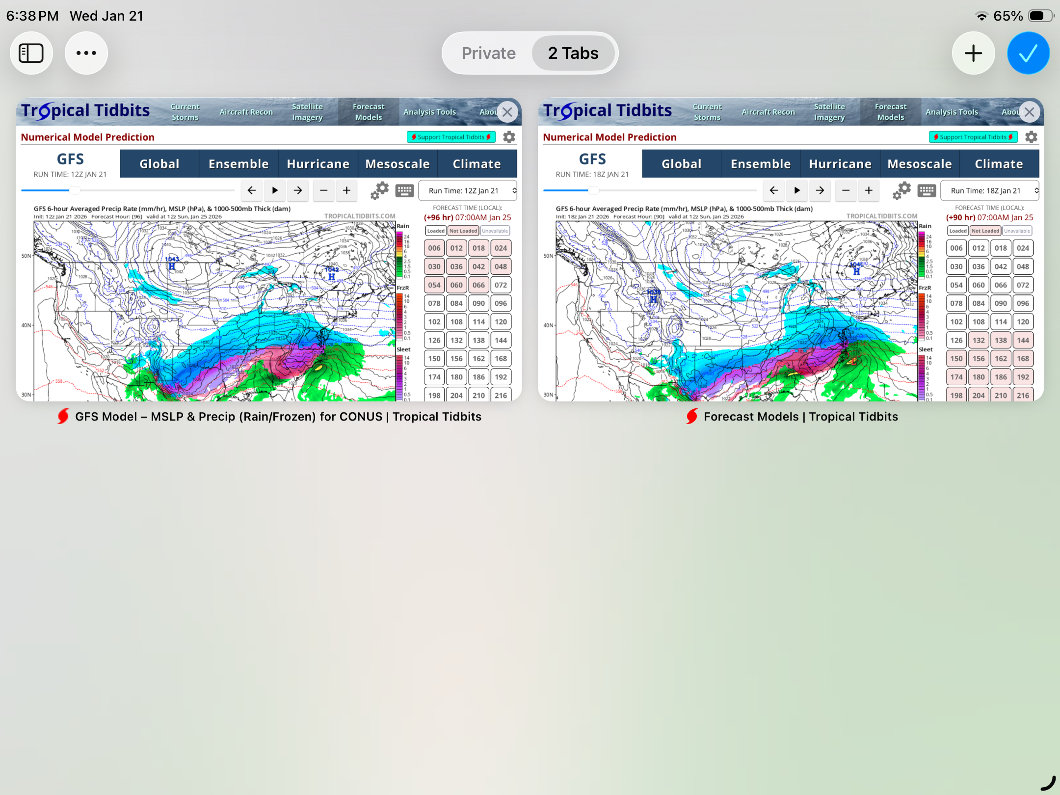
0Z GFS slaps away 18 GFS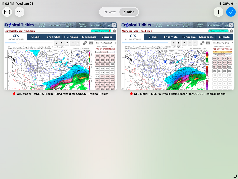
-
Pittsburgh/Western PA WINTER ‘25/‘26
north pgh replied to Burghblizz's topic in Upstate New York/Pennsylvania
Something just doesn’t look right on the 18GFS. Look at the precip shield cutoff at the Indiana state line. I expect it to come back tonight. (Hope) Fingers crossed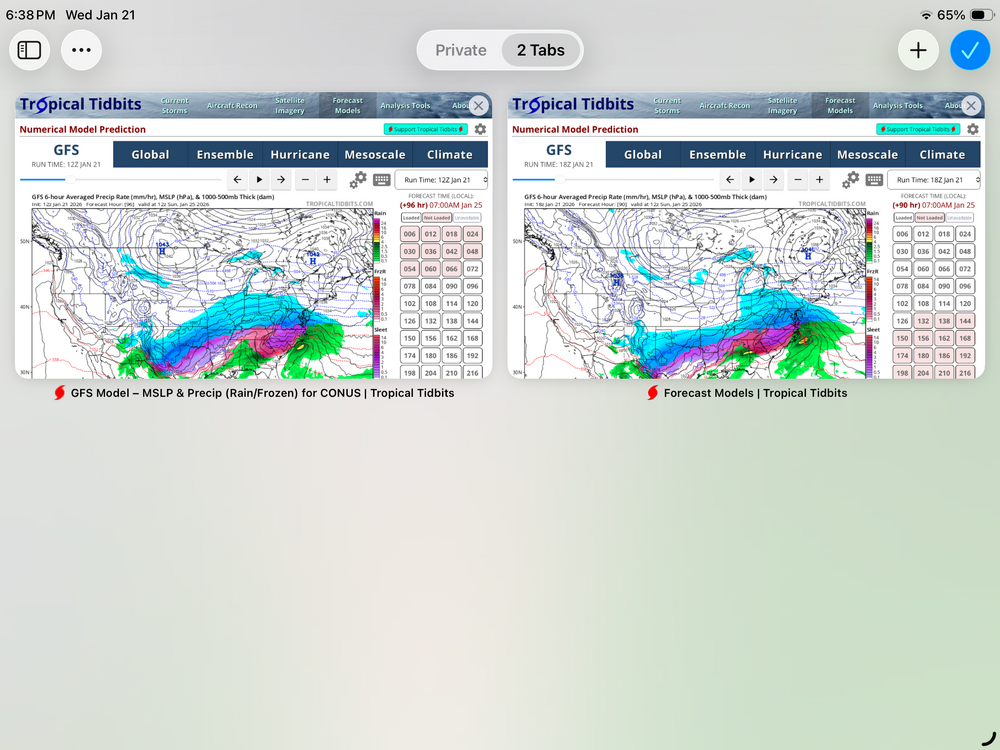
-
Pittsburgh/Western PA WINTER ‘25/‘26
north pgh replied to Burghblizz's topic in Upstate New York/Pennsylvania
Keep it coming -
Pittsburgh/Western PA WINTER ‘25/‘26
north pgh replied to Burghblizz's topic in Upstate New York/Pennsylvania
-
Pittsburgh/Western PA WINTER ‘25/‘26
north pgh replied to Burghblizz's topic in Upstate New York/Pennsylvania
So far this is trying to work it's magic. We need to shake the dust off.
-
Pittsburgh/Western PA WINTER ‘25/‘26
north pgh replied to Burghblizz's topic in Upstate New York/Pennsylvania
What reputable weather source would put out an accumulation number 6 days out? (Let alone in my 63 years on this earth I have never seen a 9-11 amount.) lol . Maybe if people click on the site, people make $$$$ -
Pittsburgh/Western PA WINTER ‘25/‘26
north pgh replied to Burghblizz's topic in Upstate New York/Pennsylvania
-
Pittsburgh/Western PA WINTER ‘25/‘26
north pgh replied to Burghblizz's topic in Upstate New York/Pennsylvania
I picked up close to 2 inches. Snow stuck to everything. Nice little surprise this morning. Waiting for a few squalls today. -
Pittsburgh/Western PA WINTER ‘25/‘26
north pgh replied to Burghblizz's topic in Upstate New York/Pennsylvania
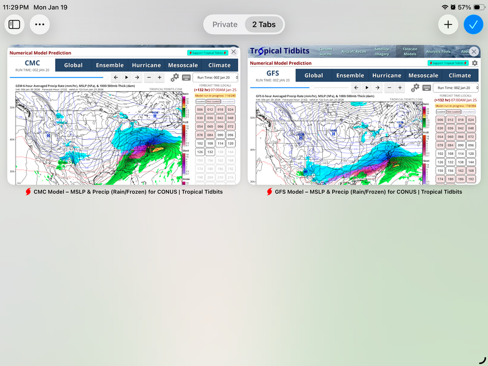
With the cold air in place and westerly flow the next 2 weeks have potential. The GFS has 3 storms totaling about 13 inches total. The Canadian has 2 storms totaling about 8. I’ll need to check out the Euro. I’ll settle for on 6-8 ordeal but if we have a foot on the ground end of month it would be grand. We are long overdue for a big one. Fingers crossed. I’ll take a nice weekend storm of about 15 inches like we had back in the early 2000s when I believe it was Wright Weather and it was always crashing. I’m much older now but smart enough to know it’s going to happen again we just don’t know when. Any way as Jackie Gleason would say “And Away We Go! “ -
Pittsburgh/Western PA WINTER ‘25/‘26
north pgh replied to Burghblizz's topic in Upstate New York/Pennsylvania
-
Pittsburgh/Western PA WINTER ‘25/‘26
north pgh replied to Burghblizz's topic in Upstate New York/Pennsylvania
High winds as well. -
Pittsburgh/Western PA WINTER ‘25/‘26
north pgh replied to Burghblizz's topic in Upstate New York/Pennsylvania
There has been some lightning observed in the squall line. Would love to to have some when it gets here. -
Pittsburgh/Western PA WINTER ‘25/‘26
north pgh replied to Burghblizz's topic in Upstate New York/Pennsylvania
Snowing moderate to heavy here for the last hour or so. Just measured 3 inches. It seems north of the city is getting it now. -
Pittsburgh/Western PA WINTER ‘25/‘26
north pgh replied to Burghblizz's topic in Upstate New York/Pennsylvania
Just got back from downtown. Beautiful snow globe night. Came home to 4 inches. Under a nice band now.