north pgh
-
Posts
3,012 -
Joined
-
Last visited
Content Type
Profiles
Blogs
Forums
American Weather
Media Demo
Store
Gallery
Everything posted by north pgh
-
Another stormy night on the way!
-

Pittsburgh/Western PA WINTER ‘25/‘26
north pgh replied to Burghblizz's topic in Upstate New York/Pennsylvania
I just took out the dog and was getting some light sleet. -
Pittsburgh/Western PA WINTER ‘25/‘26
north pgh replied to Burghblizz's topic in Upstate New York/Pennsylvania
These March days remind me of being outside in the 70’s. Snow on the ground, birds chirping, the sun comes out and you feel the warmth from it, then it gets dark and a squall comes thru and re-whitens the ground……. Rinse and repeat. -
Pittsburgh/Western PA WINTER ‘25/‘26
north pgh replied to Burghblizz's topic in Upstate New York/Pennsylvania
4 inches here. -
Pittsburgh/Western PA WINTER ‘25/‘26
north pgh replied to Burghblizz's topic in Upstate New York/Pennsylvania
-
Pittsburgh/Western PA WINTER ‘25/‘26
north pgh replied to Burghblizz's topic in Upstate New York/Pennsylvania
I guessing a good chance of a tornado watch this afternoon -
Pittsburgh/Western PA WINTER ‘25/‘26
north pgh replied to Burghblizz's topic in Upstate New York/Pennsylvania
Looking forward to some possible thunderstorms overnight and tomorrow. . -
Pittsburgh/Western PA WINTER ‘25/‘26
north pgh replied to Burghblizz's topic in Upstate New York/Pennsylvania
I'll gladly take 3-5 inches on Sunday night/Monday morning -
Pittsburgh/Western PA WINTER ‘25/‘26
north pgh replied to Burghblizz's topic in Upstate New York/Pennsylvania
Nice...GFS (In the game) -
Pittsburgh/Western PA WINTER ‘25/‘26
north pgh replied to Burghblizz's topic in Upstate New York/Pennsylvania
A solid inch and a half sticking to everything. Nice viewing as I take the dog out at 5:30. -
Pittsburgh/Western PA WINTER ‘25/‘26
north pgh replied to Burghblizz's topic in Upstate New York/Pennsylvania
Yes most models are showing about 6-10 inches less than projected. Still I nice snowfall but a lot of people thinking they were getting 20 inches will be disappointed if they only get 10. -
Pittsburgh/Western PA WINTER ‘25/‘26
north pgh replied to Burghblizz's topic in Upstate New York/Pennsylvania
Same here, except 2 inches on the grass. Beautiful morning. Don’t have to shovel -
Pittsburgh/Western PA WINTER ‘25/‘26
north pgh replied to Burghblizz's topic in Upstate New York/Pennsylvania
Just got home. Snow coming down and whitening the ground. Maybe we can eak out an inch overnight. -
Pittsburgh/Western PA WINTER ‘25/‘26
north pgh replied to Burghblizz's topic in Upstate New York/Pennsylvania
50 + MPH wind gusts. Thunderstorms last night and a couple inches of snow Sunday -Monday. Gotta love this weather. -
Pittsburgh/Western PA WINTER ‘25/‘26
north pgh replied to Burghblizz's topic in Upstate New York/Pennsylvania
It woke me up. It gets me anxious for spring storms -
Pittsburgh/Western PA WINTER ‘25/‘26
north pgh replied to Burghblizz's topic in Upstate New York/Pennsylvania
Is it safe so say models are locking in to some type of storm next Sunday? -
Pittsburgh/Western PA WINTER ‘25/‘26
north pgh replied to Burghblizz's topic in Upstate New York/Pennsylvania
-
Pittsburgh/Western PA WINTER ‘25/‘26
north pgh replied to Burghblizz's topic in Upstate New York/Pennsylvania
-
Pittsburgh/Western PA WINTER ‘25/‘26
north pgh replied to Burghblizz's topic in Upstate New York/Pennsylvania
Beautiful This Winter is reminding me more and more like growing up in the 70’s -
Pittsburgh/Western PA WINTER ‘25/‘26
north pgh replied to Burghblizz's topic in Upstate New York/Pennsylvania
-
Pittsburgh/Western PA WINTER ‘25/‘26
north pgh replied to Burghblizz's topic in Upstate New York/Pennsylvania
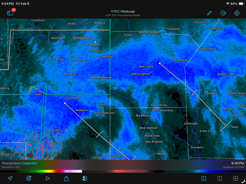
I see a lightning strike just south of Youngstown. Maybe some of us will get one when they get here. -
Pittsburgh/Western PA WINTER ‘25/‘26
north pgh replied to Burghblizz's topic in Upstate New York/Pennsylvania
The snow squalls should be here within the hour. With the inch or so of dry snow on top of the mounds of last weeks snow we should see some pretty intense blowing snow -
Pittsburgh/Western PA WINTER ‘25/‘26
north pgh replied to Burghblizz's topic in Upstate New York/Pennsylvania
Yes I was just out in it. It put down a nice coating. Visibility dropped to about 1/2 mile for about 10 minutes. Nice fluffy snow globe snow. -
Pittsburgh/Western PA WINTER ‘25/‘26
north pgh replied to Burghblizz's topic in Upstate New York/Pennsylvania
I must of saw this the same time as you, lol -
Pittsburgh/Western PA WINTER ‘25/‘26
north pgh replied to Burghblizz's topic in Upstate New York/Pennsylvania
Any one else notice that line snow squall line moving thru Cleveland? It would be interesting if it would hold together and move thru here early this evening.