north pgh
-
Posts
3,012 -
Joined
-
Last visited
Content Type
Profiles
Blogs
Forums
American Weather
Media Demo
Store
Gallery
Everything posted by north pgh
-

Pittsburgh/Western PA Winter 2024-2025 Thread
north pgh replied to Rd9108's topic in Upstate New York/Pennsylvania
Bring on the clippers! -
Pittsburgh/Western PA Winter 2024-2025 Thread
north pgh replied to Rd9108's topic in Upstate New York/Pennsylvania
GFS still needs to move west. If it's going to move it has to tonight. -
Pittsburgh/Western PA Winter 2024-2025 Thread
north pgh replied to Rd9108's topic in Upstate New York/Pennsylvania
Is there something telling you it will trend south or are you just being pessimistic? NAM throws some snow back our way off and on into the night. Another in our camp at least. -
Pittsburgh/Western PA Winter 2024-2025 Thread
north pgh replied to Rd9108's topic in Upstate New York/Pennsylvania
Saturday looks to be mostly rain but changing to light snow showers in the afternoon. Sunday looking more interesting now with system moving a little more north west. We could have a nice snow day even if we are not going to be in the heaviest snow. I’ll take another 1-3. -
Pittsburgh/Western PA Winter 2024-2025 Thread
north pgh replied to Rd9108's topic in Upstate New York/Pennsylvania
What a month so far! These cold days with snow in the air remind me of my youth in the 70's. I would have been outside sled riding and having snowball battles every day and coming in with wet clothes and being sent to the basement to change into dry clothes. (no cable tv or play station) Yes I'm old. I picked up 3.5 inches today and currently have 6-7 on the ground in my yard. It's been a couple years since we have had that much snow cover. With the cold temperatures and the snow cover I believe it will help for our next few storms by keeping the temps down. -
Pittsburgh/Western PA Winter 2024-2025 Thread
north pgh replied to Rd9108's topic in Upstate New York/Pennsylvania
I am right under this heavy band. WOW! Easily multiple inch per hour rates. -
Pittsburgh/Western PA Winter 2024-2025 Thread
north pgh replied to Rd9108's topic in Upstate New York/Pennsylvania
I think Thursday will be better than today. 1-2 inches. Saturday is trending colder so we may have snow Friday night and more of a mix Saturday then back to snow. NWS thinks so too. Friday Night A chance of snow after 1am. Mostly cloudy, with a low around 27. Chance of precipitation is 30%. Saturday Rain and snow. High near 38. Chance of precipitation is 90%. Saturday Night A chance of snow before 1am. Mostly cloudy, with a low around 19. Chance of precipitation is 30%. Sunday A chance of snow. Mostly cloudy, with a high near 23. Chance of precipitation is 40%. Sunday Night A chance of snow. Mostly cloudy, with a low around 6. Chance of precipitation is 40% -
Pittsburgh/Western PA Winter 2024-2025 Thread
north pgh replied to Rd9108's topic in Upstate New York/Pennsylvania
Yep. Other than Saturday the next 10 days will be cold. -
Pittsburgh/Western PA Winter 2024-2025 Thread
north pgh replied to Rd9108's topic in Upstate New York/Pennsylvania
And over my house as well. I was out about an hour ago and it started to flurry but now nothing. -
Pittsburgh/Western PA Winter 2024-2025 Thread
north pgh replied to Rd9108's topic in Upstate New York/Pennsylvania
Light snow is starting now. That snow hole (dry slot) that was showing on all the models has held tight for the last 2+ hours. -
Pittsburgh/Western PA Winter 2024-2025 Thread
north pgh replied to Rd9108's topic in Upstate New York/Pennsylvania
It looks like some snow bands to our northwest. Some of us may wake up to another inch of fluffy snow. -
Pittsburgh/Western PA Winter 2024-2025 Thread
north pgh replied to Rd9108's topic in Upstate New York/Pennsylvania
Heavy snow for the past hour. Picked up 2 inches. I had to shovel my driveway out. I have a steep driveway. A surprise as I have to go out shortly. -
Pittsburgh/Western PA Winter 2024-2025 Thread
north pgh replied to Rd9108's topic in Upstate New York/Pennsylvania
I remember them too in the 70's. It looks like that band is still going on your way. We had that over our area all morning. Maybe a few overperforming clippers next week. -
Pittsburgh/Western PA Winter 2024-2025 Thread
north pgh replied to Rd9108's topic in Upstate New York/Pennsylvania
Picked up a fluffy 1/2 inch overnight ☃️ -
Pittsburgh/Western PA Winter 2024-2025 Thread
north pgh replied to Rd9108's topic in Upstate New York/Pennsylvania
Yes I was going to say the same thing. It looks like snow has made it to the south hills. Can anyone down there confirm. Here there is just a few flurries. -
Pittsburgh/Western PA Winter 2024-2025 Thread
north pgh replied to Rd9108's topic in Upstate New York/Pennsylvania
Car doesn’t even need cleared off -
Pittsburgh/Western PA Winter 2024-2025 Thread
north pgh replied to Rd9108's topic in Upstate New York/Pennsylvania
This seems to be the only one in our camp. All other models are showing 1-3. -
Pittsburgh/Western PA Winter 2024-2025 Thread
north pgh replied to Rd9108's topic in Upstate New York/Pennsylvania
Let’s hope NAM is lost on cutoff line. -
Pittsburgh/Western PA Winter 2024-2025 Thread
north pgh replied to Rd9108's topic in Upstate New York/Pennsylvania
There might be some snow squall warnings tomorrow afternoon -
Pittsburgh/Western PA Winter 2024-2025 Thread
north pgh replied to Rd9108's topic in Upstate New York/Pennsylvania
Agree -
Pittsburgh/Western PA Winter 2024-2025 Thread
north pgh replied to Rd9108's topic in Upstate New York/Pennsylvania
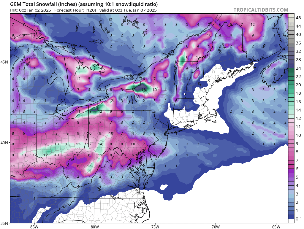
Things still looking up. It looks like 1-2 over the next couple days. If things hold together we could be seeing another 2-4 3-5 on Monday with about 9 hours of snow falling. Even if the system moves north and we get some mix or moves south and we only get 1-2 more it will stick around for at least 2 weeks as the cold will be here and more opportunities arise. -
Pittsburgh/Western PA Winter 2024-2025 Thread
north pgh replied to Rd9108's topic in Upstate New York/Pennsylvania
I like me some Canadian please.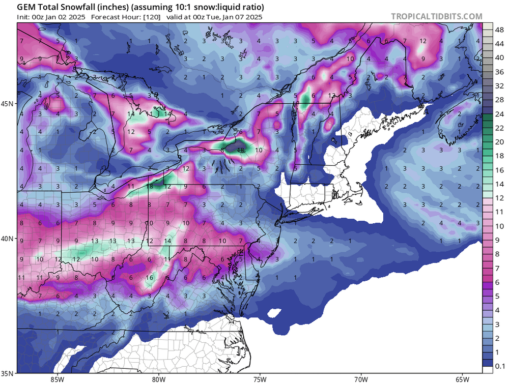
-
Pittsburgh/Western PA Winter 2024-2025 Thread
north pgh replied to Rd9108's topic in Upstate New York/Pennsylvania
Merry Christmas everyone. Let's have a rockin January and February! -
Pittsburgh/Western PA Winter 2024-2025 Thread
north pgh replied to Rd9108's topic in Upstate New York/Pennsylvania
4 inches in Ross. The band seems to be drifting south. I hope you all can get in on the snow. -
Pittsburgh/Western PA Winter 2024-2025 Thread
north pgh replied to Rd9108's topic in Upstate New York/Pennsylvania
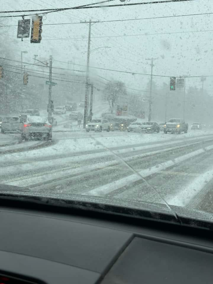
McKnight road.