north pgh
-
Posts
3,012 -
Joined
-
Last visited
Content Type
Profiles
Blogs
Forums
American Weather
Media Demo
Store
Gallery
Everything posted by north pgh
-

Pittsburgh, Pa Winter 2023-24 Thread.
north pgh replied to meatwad's topic in Upstate New York/Pennsylvania
About an inch of the fluffy stuff. -
Pittsburgh, Pa Winter 2023-24 Thread.
north pgh replied to meatwad's topic in Upstate New York/Pennsylvania
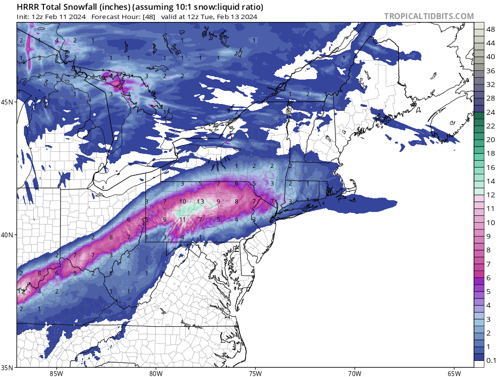
Remember that this snow is mostly going to fall over a 6 hour or so period so to even get 2-4 inches it will snow at least 1/2 inch an hour which is pretty good rates. Even an inch an hour in some cases. -
Pittsburgh, Pa Winter 2023-24 Thread.
north pgh replied to meatwad's topic in Upstate New York/Pennsylvania
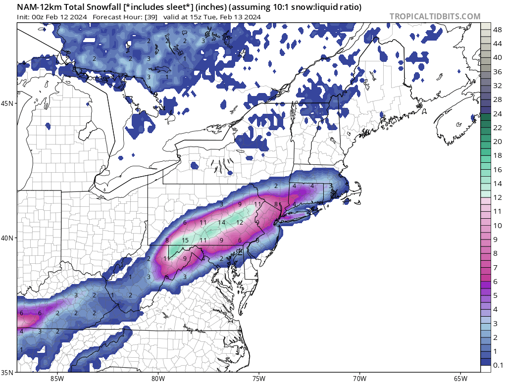
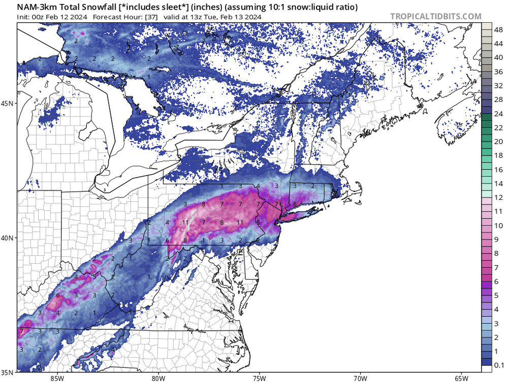
NAM is North -
Pittsburgh, Pa Winter 2023-24 Thread.
north pgh replied to meatwad's topic in Upstate New York/Pennsylvania
Wind is really howling out there. Rain about to blow through. As far as tomorrow I trust the Canadian after how it scored the last one. I think 1-2 is a solid bet tomorrow night. -
Pittsburgh, Pa Winter 2023-24 Thread.
north pgh replied to meatwad's topic in Upstate New York/Pennsylvania
Unless it goes further south LOL -
Pittsburgh, Pa Winter 2023-24 Thread.
north pgh replied to meatwad's topic in Upstate New York/Pennsylvania
Don't get me wrong, I will take a 1-3 storm anytime during the day but if it happens while I'm asleep then to me it's no fun shoveling it if you can't see it falling. -
Pittsburgh, Pa Winter 2023-24 Thread.
north pgh replied to meatwad's topic in Upstate New York/Pennsylvania
This storm is moving so fast we probably wouldn't even see a flake fall unless you were awake at 4:00 am. I'll drive to my meeting tomorrow morning with a few flakes in the air and bare wet ground and take it. On to the next week. No biggie. -
Pittsburgh, Pa Winter 2023-24 Thread.
north pgh replied to meatwad's topic in Upstate New York/Pennsylvania
Yes these models are ridiculous. -
Pittsburgh, Pa Winter 2023-24 Thread.
north pgh replied to meatwad's topic in Upstate New York/Pennsylvania
-
Pittsburgh, Pa Winter 2023-24 Thread.
north pgh replied to meatwad's topic in Upstate New York/Pennsylvania
-
Pittsburgh, Pa Winter 2023-24 Thread.
north pgh replied to meatwad's topic in Upstate New York/Pennsylvania
Boy I was making fun of the Canadian for being so far east but it was right. -
Pittsburgh, Pa Winter 2023-24 Thread.
north pgh replied to meatwad's topic in Upstate New York/Pennsylvania
Hazardous Weather Outlook National Weather Service Pittsburgh PA 1258 PM EST Sun Feb 11 2024 OHZ041-PAZ007-013-014-020>022-073-077-078-121800- Columbiana-Mercer-Lawrence-Butler-Beaver-Allegheny-Armstrong- Westmoreland-Indiana-Higher Elevations of Indiana- 1258 PM EST Sun Feb 11 2024 This Hazardous Weather Outlook is for east central Ohio and western Pennsylvania. .DAY ONE...This afternoon and tonight. Hazardous weather is not expected at this time. .DAYS TWO THROUGH SEVEN...Monday through Saturday. There is a chance for winter weather impacts early Tuesday morning with a crossing low pressure system. There still remains a lot of uncertainty in precipitaiton type, snow liquid ratios, and the position of snow bands. A Winter Weather Advisory or Winter Storm Warning may need to be issued in the next 24 hours. .SPOTTER INFORMATION STATEMENT... Spotter activation is not expected at this time. $$ -
Pittsburgh, Pa Winter 2023-24 Thread.
north pgh replied to meatwad's topic in Upstate New York/Pennsylvania
I think we are looking at a 1-3 event with most of it falling while I'm asleep which are not my favorite storms. Wake up, shovel and then watch it start melting Tuesday afternoon. Yawn. -
Pittsburgh, Pa Winter 2023-24 Thread.
north pgh replied to meatwad's topic in Upstate New York/Pennsylvania
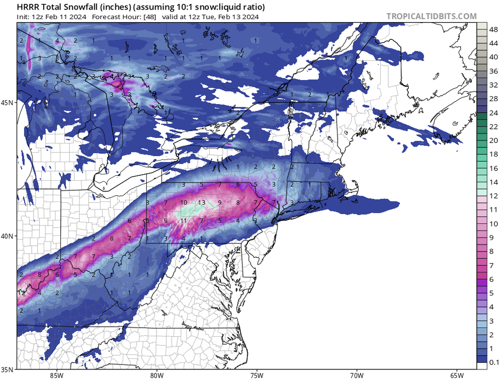
-
Pittsburgh, Pa Winter 2023-24 Thread.
north pgh replied to meatwad's topic in Upstate New York/Pennsylvania
As usual it will turn out to be an I-80 special. The only hope we have is that it drops south 50 miles tomorrow. Can only hope. -
Pittsburgh, Pa Winter 2023-24 Thread.
north pgh replied to meatwad's topic in Upstate New York/Pennsylvania
I'm pretty sure that the Canadian will come North but that would put us in a sweet spot at least for now on that model. -
Pittsburgh, Pa Winter 2023-24 Thread.
north pgh replied to meatwad's topic in Upstate New York/Pennsylvania
Agree 100%. Odds are in our favor for a decent hit only because we haven't had one for so long but are against us because we are most likely to get fringed. -
Pittsburgh, Pa Winter 2023-24 Thread.
north pgh replied to meatwad's topic in Upstate New York/Pennsylvania
We may not find out until Sunday night or Nowcasting on Monday. -
Pittsburgh, Pa Winter 2023-24 Thread.
north pgh replied to meatwad's topic in Upstate New York/Pennsylvania
Maybe a Thunderstorm early tomorrow? -
Pittsburgh, Pa Winter 2023-24 Thread.
north pgh replied to meatwad's topic in Upstate New York/Pennsylvania
Euro has the storm as well. Storm is there. Now it will be a matter of track and precip type and amounts. I am sure that there will be ups and downs through the next 3-4 days. -
Pittsburgh, Pa Winter 2023-24 Thread.
north pgh replied to meatwad's topic in Upstate New York/Pennsylvania
I think regardless of whether we can land something Tuesday, The cold NW flow kicks in the rest of the week. At this point I'd be happy to see a clipper move in during this time. -
Pittsburgh, Pa Winter 2023-24 Thread.
north pgh replied to meatwad's topic in Upstate New York/Pennsylvania
Tuesday and Sunday of next week may be our best chance of landing a good snowfall. At least we can start tracking again maybe. -
Pittsburgh/Western PA Banter & Complaint Thread
north pgh replied to blackngoldrules's topic in Upstate New York/Pennsylvania
Tomorrow is groundhog day -
Pittsburgh, Pa Winter 2023-24 Thread.
north pgh replied to meatwad's topic in Upstate New York/Pennsylvania
URGENT - WINTER WEATHER MESSAGE National Weather Service Pittsburgh PA 1136 AM EST Mon Jan 22 2024 OHZ039-048>050-057>059-068-PAZ021-029-073-077-078-WVZ001>003-230300- /O.EXA.KPBZ.WW.Y.0009.240123T0600Z-240123T1700Z/ Tuscarawas-Coshocton-Harrison-Jefferson OH-Muskingum-Guernsey- Belmont-Noble-Allegheny-Washington-Westmoreland-Indiana-Higher Elevations of Indiana-Hancock-Brooke-Ohio- Including the cities of New Kensington, Monessen, Indiana, Armagh, Caldwell, Martins Ferry, New Philadelphia, Pittsburgh Metro Area, Greensburg, Wheeling, St. Clairsville, Wellsburg, Latrobe, Cadiz, Weirton, Murrysville, Canonsburg, Coshocton, Dover, Steubenville, Washington, Cambridge, Lower Burrell, Follansbee, and Zanesville 1136 AM EST Mon Jan 22 2024 ...WINTER WEATHER ADVISORY IN EFFECT FROM 1 AM TO NOON EST TUESDAY... * WHAT...Freezing rain expected. Total snow accumulations up to one inch north of I-80 and ice accumulations up to one tenth of an inch. * WHERE...Portions of east central Ohio, southwest and western Pennsylvania, and northern and the northern panhandle of West Virginia. * WHEN...From 1 AM to noon EST Tuesday. * IMPACTS...Plan on slippery road conditions. The hazardous conditions could impact the Tuesday morning commute. PRECAUTIONARY/PREPAREDNESS ACTIONS... Slow down and use caution while traveling. The latest road conditions can be obtained by calling 5 1 1. Please report snow or ice accumulations by calling 412-262-1988, posting to the NWS Pittsburgh Facebook page, or using Twitter @NWSPittsburgh. && $$ -
Pittsburgh, Pa Winter 2023-24 Thread.
north pgh replied to meatwad's topic in Upstate New York/Pennsylvania
Congrats south hills posters! You deserved it.