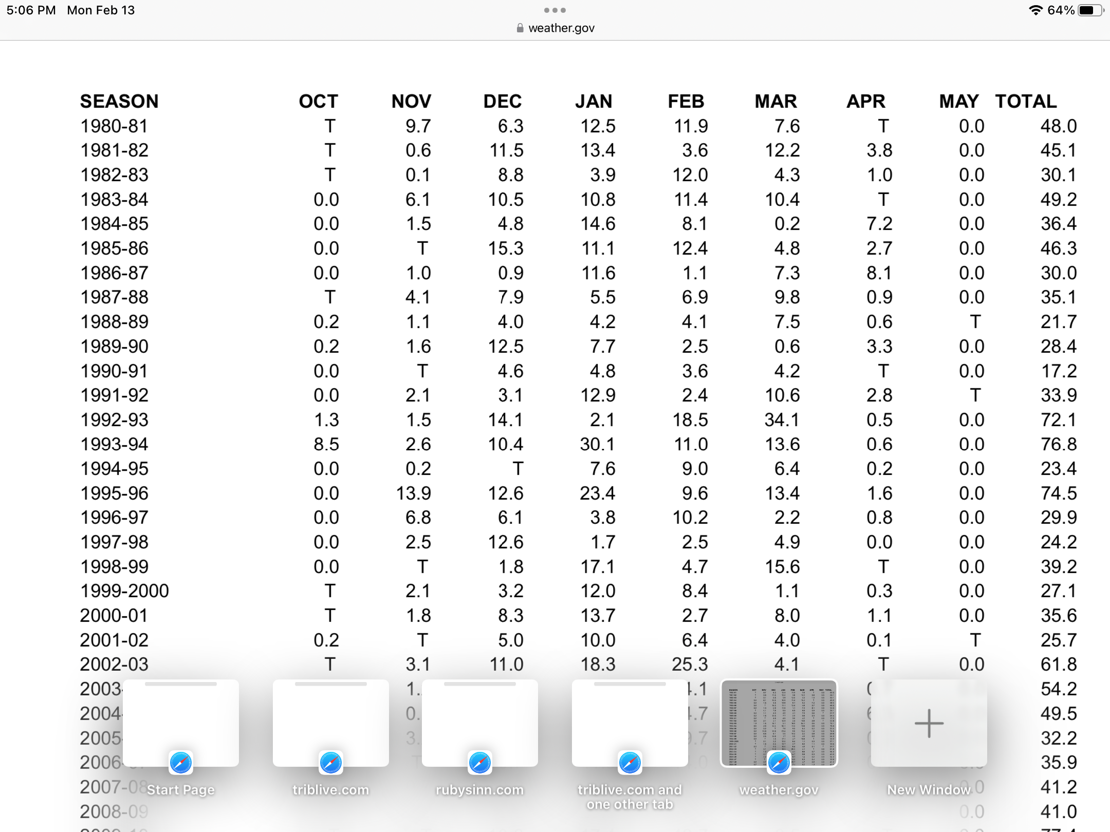
north pgh
-
Posts
3,012 -
Joined
-
Last visited
Content Type
Profiles
Blogs
Forums
American Weather
Media Demo
Store
Gallery
Everything posted by north pgh
-
 Just for pleasure and to laugh. HAHAHAHAHAHAHAHAHAHAHAHAHAHAH
 -
I am traveling next weekend. If it is going to verify, this would be the time.
-
I’ll take this year if we get 70 inches of snow 2 out of the next 3 years.

-
Yes it has been a disappointing snow year. But some of us, me included say that I would trade the nickel and dimes for a big storm. Okay let’s bring on a foot storm. We have a month left. That’s all we can hope for.
-
Pittsburgh/Western PA Banter & Complaint Thread
north pgh replied to blackngoldrules's topic in Upstate New York/Pennsylvania
Even today's "Wind Advisory" has been a bust. -
Heck with all this rain showing up on the models it might be a good time to plant some grass.
-
GFS and Canadian are starting to come around to something possibly next Saturday.
-
One little streamer put down a solid dusting.
-
It’s cold out there.
-
Or those smokestacks in Beaver County.
-
Yes about 1/2 inch here and my side street and driveway is covered. Visibility under a mile.
-
Nice batch of heavier snow has developed and moved in.
-
Light snow falling now. Temp is 34
-
You know we are in a bad stretch of winter weather when I get excited driving an hour ago and we start to get some light sleet.
-
It looks like next weeks storm is just south of us. If it comes north we will be in good shape as long as it doesn't end up cutting.
-
Yes looking forward to it.
-
Yes NWS nailed it. Maybe an inch before the switch. That last batch moving in last hour was a dud. At least the rain line will be all the way up to Buffalo this afternoon so we really won’t miss much close by. We’re all in the same boat. Maybe tomorrow will outdo today with some off and on snow showers.
-
Sleet is here.
-
Heavy snow about to move into Allegheny County. Bring it on!
-
2 or 3 hours of moderate to heavy snow could give most of us a surprise 3 inches. I'd take it. Forget the forecast it's nowcast time
-
That hole has filled in and it is now snowing hard. Just wait until NWS ups that less than 1/2 inch soon. Enjoy the morning.
-
No. I'm just getting older. This model watching is always bad when you are waiting for something that happens 10% of the time. Look at the glass half full.
-
Too negative guys. I like the trends. Some back end as well and maybe this weekend. I can see 4 or 5 inches on the ground after this weekend. Tomorrow morning may be a nice surprise. I'll take 3 inches if it falls in 3 hours.
-
It's time.
-
If the long term GFS holds it is going to be mighty cold later next week.